 Society
Việt Nam fosters comprehensive cooperation with Uruguay
1.
|
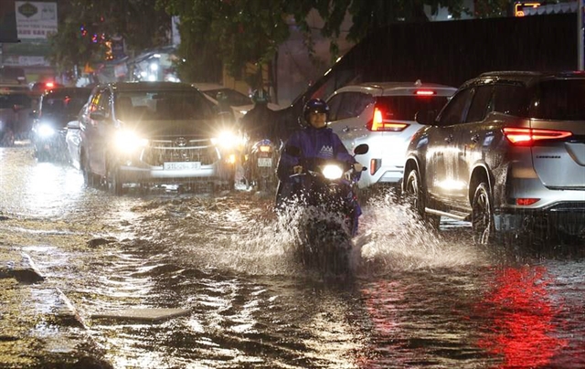
| Heavy rain and high tides regularly strain HCM City urban infrastructure. — VNA/VNS Photo Hồng Đạt |
HCM CITY — HCM City is overhauling its anti-flooding strategy, shifting from traditional drainage engineering to integrated flood risk management that integrates spatial urban planning, green infrastructure, and water retention space to tackle extreme weather and tidal surges.
Under the Resolution No 09-NQ/TW promulgated by the Communist Party of Việt Nam, the southern metropolis aims to fundamentally resolve urban flooding, traffic congestion, and environmental pollution by 2030.
Rather than reactively raising roads or building isolated dykes, the city is embedding water management directly into its master urban plan across 23 major drainage basins.
Recent widespread downpours have highlighted the city’s severe infrastructure strain.
The city currently contends with 159 flood points, including 138 triggered by extreme rainfall, 10 by Sài Gòn - Đồng Nai river tides, and 11 by combined rain and tidal surges.
The crisis stems from low lying topography, an outdated drainage network, climate driven rainfall intensity, and high tides.
This situation is further aggravated by localised land subsidence averaging 2.5 centimetres per year and high concrete coverage.
Additional pressure comes from upstream reservoir releases alongside nearly 400 canals encroached upon or blocked by waste.
Integrated strategy and spatial risk zoning
Lê Ngọc Linh, deputy director of the city’s Department of Construction, said the core of the new strategy is moving away from merely flushing water out as fast as possible.
Instead, the city is adopting a three-tier spatial framework: Retardation (slowing flow velocity), Storage (retaining runoff in retention basins and green spaces), and Drainage.
“When these three layers are insufficient, protective structures are deployed.”
This framework merges traditional grey infrastructure with nature-based solutions (NbS), permeable pavements, rain gardens, and Sustainable Urban Drainage Systems (SuDS).
To apply tailored solutions, flood risk management expert Hoàng Quang Huy from international consultancy Haskoning proposes categorising the city into five distinct risk zones.
Zone I, covering the old urban core, requires high protection via smart sluice and pump systems, gravity based main discharge routes, SCADA digital controls, and strict canal corridor preservation.
Zone II, comprising riverside and coastal industrial hubs, focuses on localised dikes, elevated building foundations, integrated internal green networks to reduce peak runoff, and separated stormwater wastewater systems.
Zone III, encompassing semi flooded areas and river corridors, involves flood storage corridors, wetland parks, and widened river chokepoints along the Sài Gòn Đồng Nai basin to expand natural discharge capacity.
Zone IV, consisting of estuary and coastal zones, relies on nature based protections like mangrove restoration, soft embankments, and artificial sandbars combined with wave energy dissipaters.
Zone V, representing new development and redevelopment areas, adopts the Sponge City model to absorb rainfall naturally and prevent urban growth from exacerbating flood risks.
Experts also advocate evaluating Polder (dike ring) systems against traditional land levelling.
While land levelling requires heavy initial investment and vast sand resources, which often shifts flood risks to neighbouring areas, Polders offer greater flexibility against subsidence and climate change at a lower initial capital cost.
|
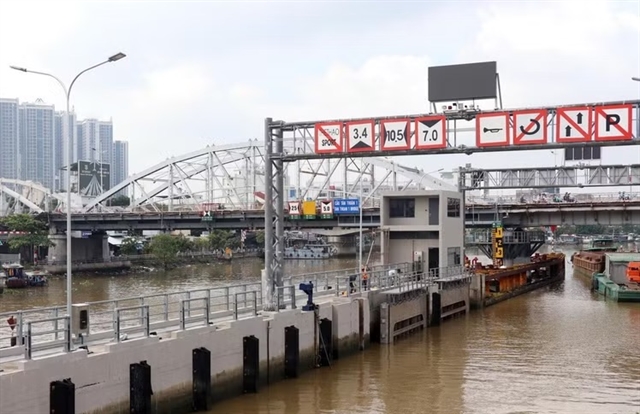
| Tân Thuận tidal control sluice structure in HCM City preparing for operational trials. — VNA/VNS Photo Tiến Lực |
Structural progress and long-term planning
While long-term spatial planning takes shape, major structural works under Phase 1 of the Tidal Flood Control Project (An Triều Project) are entering their final stages to protect low-lying areas.
The Bến Nghé tidal control sluice is 99 per cent complete and undergoing periodic trial operations ahead of handover.
The Tân Thuận and Phú Xuân sluices have reached 95 per cent completion, with MEPP equipment and SCADA control systems being finalised for trial runs in October.
Meanwhile, the Mương Chuối and Cây Khô sluices stand at 94 per cent completion, with testing targeted for November and October, respectively.
The Phú Định sluice is 93 per cent complete and set for testing in November, while Cầu Kinh and Bà Bướm have reached 96 per cent completion and begin trial operations this month.
The central control facility, currently at 93 per cent completion, will synchronise the entire system by November.
These facilities aim to block tidal surges, regulate river water levels, relieve sewer pressure, and temporarily hold runoff during combined heavy rains and high tides.
Concurrently, the city is preparing to adjust its Flood Prevention and Wastewater Treatment Master Plan for 2026-30, with consultancy work concluding by late October.
Between now and 2030, the city plans to invest approximately VNĐ140 trillion (US$5.6 billion) across 87 projects to resolve 50 major flood points.
It also aims to collect over 80 per cent of urban wastewater and treat 40-45 per cent to standard levels by 2030, up from current rates of 52 per cent and 19.5 per cent, respectively.
Transitioning from administrative boundaries to basin wide water management, including the potential establishment of a centralised water agency, is strongly recommended alongside digital tools such as real time flood warning platforms and Digital Twin simulations.
According to the prominent architect and urban planner Dr Ngô Viết Nam Sơn, the city must plan for a 50-to-100-year horizon to withstand sea-level rise.
He recommended reserving low-lying southern areas for water bodies and eco-parks, while directing high-density development toward higher terrain like Bình Dương, Củ Chi, and Hóc Môn areas to reduce inner-city pressure while preserving ecological balance. — VNS
Society
 Society
 Society
 Society
 Society
 Society
 Society
 Society
 Society
 Society
 Society
 Society
 Society
 Society
 Society