(4).jpg) Society
Society


DHL breaks ground on $71 million logistics campus in Hưng Yên
1.
|
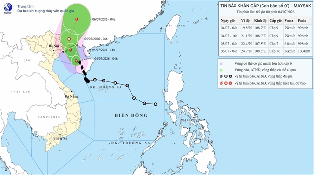
| Forecast track of Storm Maysak over the coming days. — Photo nchmf.gov.vn |
HÀ NỘI — Storm Maysak, designated as Storm No.1 in Việt Nam, is on track to weaken into a tropical depression over southern China within 24 hours, forecasters said on Saturday, after brushing past the country's northern coast with winds up to level 8-9 (62-88km/h) on the Beaufort scale and gusts as strong as level 11 (103-117km/h).
The storm sat roughly 80km off Bạch Long Vĩ, an island administered by the coastal city of Hải Phòng, at 6am on Saturday, and about 180km from the border city of Móng Cái in the northern province of Quảng Ninh.
It was creeping northwest at 15km/h, according to the National Centre for Hydro-Meteorological Forecasting.
Forecasters expect the storm to pass just off Quảng Ninh's coast by mid-afternoon, still at the same intensity, then bend north-northwest and push into China's Guangxi region overnight.
There, it would lose steam fast, dropping to level 7 (50-61km/h) winds by Sunday morning and dissolving into a weak low-pressure system by Monday.
Authorities have put the northern Gulf of Tonkin under a level 3 storm alert, covering the islands of Bạch Long Vĩ, Vân Đồn, Cô Tô and Cát Hải, as well as coastal waters stretching from Quảng Ninh down to Hưng Yên.
Conditions are expected to turn hazardous offshore: winds gusting to level 11 (103-117km/h) and waves as high as four metres could easily flip or wreck fishing boats, cargo ships and tourist vessels.
Fish farms and harbours are also at risk, and forecasters expect fishing, shipping and tourism to grind to a halt in the storm's path.

|
| A border guard uses a loudspeaker to urge fishermen to move their boats to shelter. — VNA/VNS Photo |
Residents along the Quảng Ninh, Hải Phòng and Hưng Yên coastline should brace for strong winds and a storm surge of up to 40cm starting around midday Saturday.
Forecasters warned the wind could tear off roofs, snap trees and knock out power and phone lines, while surging water threatens to flood low-lying areas near river mouths and put pressure on sea dikes.
Inland, the storm is expected to dump heavy rain across the northeast and Thanh Hóa Province through Sunday, generally 100 to 200mm, but as much as 300mm in the northeast, with isolated pockets seeing over 500mm.
That kind of rainfall raises the risk of urban flooding, flash floods and landslides, particularly in mountainous areas.
Forecasters also cautioned that thunderstorms and sudden strong gusts could strike both ahead of and during the storm's approach, and urged people in its path to stay alert to official updates. — VNS
Society
 Society
 Society
 Society
 Society
 Society
 Society
 Society
 Society
 Society
 Society
 Society
.jpg) Society
Society
 Society
 Society