 Society

Vietnamese community in Japan gradually returns to normal after earthquake disaster
1.
|
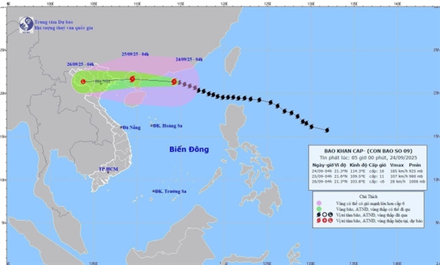
| The predicted path of Typhoon Ragasa as of 4am on Wednesday. Photo: National Centre for Hydro-Meteorological Forecasting |
HÀ NỘI– After moving into the southern waters off China's Guangdong province on Wednesday morning, Typhoon Ragasa, the ninth arising in the East Sea this year, weakened to level 15, no longer classified as a super typhoon, according to Dr. Hoàng Phúc Lâm, Deputy Director of the National Centre for Hydro-Meteorological Forecasting.
Lâm said that at about 7am on Wednesday, the storm’s centre was at about 21.3 degrees North and 113.7 degrees East, some 620km east of Móng Cái of northern Quảng Ninh Province. Maximum winds near the eye reached level 15 (167–183 km per hour), with gusts exceeding level 17. The storm was moving west-northwest at around 20km per hour.
The forecasting centre said that by 7am on Thursday, the storm will be on the waters off Quảng Ninh and Hải Phòng, with wind speeds at levels 10–11, gusting above level 13. It is expected to move northwest at some 20–25km per hour and continue to abate. The northern Gulf of Tonkin and northeastern region will face a disaster risk at Category 3, the third highest on a five-level scale.
By 7am on Friday, Ragasa is predicted to be located on the northwestern region, with wind speeds dropping to below level 6. It will move west and continue to weaken into a tropical depression and then a low-pressure area.
However, from the evening of September 24 through September 26, heavy rainfall is expected across the North, and the north-central provinces of Thanh Hóa and Nghệ An, with total rainfall ranging from 100–250mm, even exceeding 400mm in certain places. This poses a risk of urban flooding and low-lying areas, flash floods in small rivers, and landslides in mountainous areas.
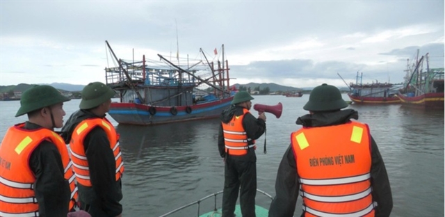
In addition, the storm will severely impact the northern part of the Gulf of Tonkin, especially areas like Bạch Long Vĩ, Vân Đồn, Cô Tô, Cát Hải, and Hòn Dáu islands, with winds reaching levels 9–10 near the eye, and waves rising to 3–5m. Coastal areas in Quảng Ninh, particularly aquaculture farms, will be severely affected by strong winds and large waves, with a high risk of embankment and seawall erosion.
These ongoing developments will continue to have a major impact on the northern region and coastal areas, requiring proactive measures to address the potential dangers of flooding and strong winds. VNA/VNS
Society
 Society
 Society
 Society
 Society
 Society
 Society
 Society
 Society
 Society
 Society
 Society
 Society
.jpg) Society
Society
 Society