 Society

Việt Nam, EU and Belgium seek deeper, practical cooperation
1.
|
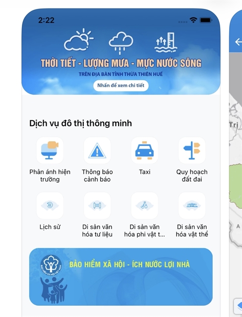
| The "Hue-S" application, where users can view flood forecasting data. — Photo screenshot from the App Store |
HUẾ — Huế is modernising its disaster prevention and response capabilities by integrating advanced technologies, including artificial intelligence and real-time radar data, into its smart city platforms.
During this ongoing rainy season, the city has established a robust physical monitoring network comprising 52 automatic rain gauges, three wind speed sensors, eight flood monitoring stations, four supplementary water level stations on the Hương and Bồ rivers, and six coastal hydro-meteorological stations.
Data from this extensive system is directly integrated into digital platforms, notably "Hue-S", a local administrative application that has some 1.3 million users.
In addition to broadcasting early warnings 48 to 72 hours ahead of severe weather via digital channels, the city is piloting high-capacity sirens with a five-kilometre radius to physically alert the public.
To guarantee uninterrupted coordination during these events, the city is also finalising the deployment of Starlink satellite internet terminals, aiming to eliminate communication blind spots in isolated areas.
The city has also piloted a real-time flood simulation model driven by AI.
According to Assoc. Prof. Dr Huỳnh Công Hoài of the HCM City University of Technology, the system utilises the Telemac-2D hydraulic model to simulate historical floods across over 300,000 data points.
This extensive dataset trains an AI model capable of forecasting a flood scenario in under three minutes, providing predictive windows ranging from 15 minutes to 24 hours with a target accuracy of over 70 per cent.
The system is designed to generate 12 specific flood maps corresponding to 12 reservoir regulation scenarios, allowing authorities to pinpoint areas and households at risk and requiring evacuation.
From an operational perspective, Dr Trần Hữu Tuyên of the Huế University of Sciences noted that digitising these processes concretises inter-reservoir decisions, calculating exact discharge rates for three reservoirs to simulate various flood progression scenarios.
These real-time projections, alongside feeds from around 100 intelligent cameras, are directly transmitted to the public via the Hue-S app, enabling people to safeguard their properties and plan evacuations.
In future, the city plans to expand its technical infrastructure by deploying unmanned aerial vehicles and satellite imagery.
Authorities will also promote the use of specialised software such as Vrain, Hue.vfass, and Hue.vwind to establish a unified digital database for disaster management.
These digital transformation efforts in disaster management are being implemented in line with Resolution No. 57-NQ/TW on facilitating breakthroughs in the development of science, technology, innovation, and national digital transformation
Ultimately, by digitalising its disaster warning systems, Huế seeks not only to enhance its emergency response but also to strategically link long-term water security with the sustainable livelihoods of local communities, all in an effective and modern manner. — VNS
Society
 Society
 Society
 Society
 Society
 Society
 Society
 Society
 Society
 Society
 Society
 Society
 Society
 Society
 Society