 Society

Vietnamese Prime Minister meets Cambodian National Assembly President
1.
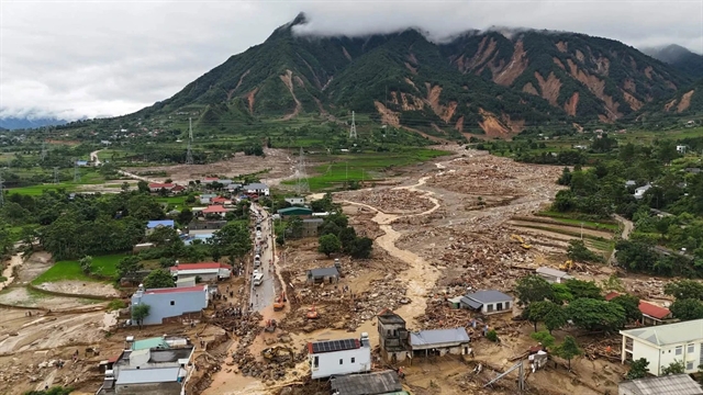 |
| Many villages in Lai Châu Province suffer extensive damages from flash flood and landslide. — VNA/VNS Photo |
HÀ NỘI — Flooding and landslides in the northern region have left six people dead, two missing and 10 injured, with total economic losses estimated at nearly VNĐ443 billion (US$17 million), as damage continued to mount in Lai Châu and Sơn La.
Lai Châu, a mountainous province characterised by steep terrain and a dense network of rivers and streams, has been the hardest-hit locality during the recent flooding in northern Việt Nam's mountainous region.
Flash floods and landslides directly affected 899 households, comprising 4,263 residents, in the villages of Chít, Khì, Nậm Sáng, Noong Thăng, and Nậm Ngùa.
The province recorded six fatalities, while two people remain missing and 10 others were injured.
The disaster destroyed 28 houses, damaged a further 224 homes and affected more than 408 hectares of rice and other crops. Livestock production and infrastructure also sustained extensive damage.
As of noon on July 20, total losses in Lai Châu were estimated at more than VNĐ270 billion ($10.4 million), a sharp increase from earlier assessments. Mường Than Commune alone accounted for around VNĐ120 billion ($4.6 million) in damage.
In neighbouring Sơn La Province, estimated losses also rose significantly to around VNĐ125 billion ($4.8 million).
Lào Cai Province also suffered extensive damage after prolonged heavy rainfall triggered flash floods, landslides and inundation. Total losses there were estimated at more than VNĐ45 billion ($1.7 million).
Meanwhile, Điện Biên Province reported damage of about VNĐ2.3 billion ($89,000).
Causes of devastating flash flood
According to weather experts, exceptionally heavy rainfall exceeding the resilience of infrastructure in Việt Nam's northern mountainous region, combined with a sudden surge of floodwaters from upstream areas, has saturated hillsides and triggered widespread landslides, flash floods and debris flows in provinces including Lai Châu, Lào Cai, and Sơn La.
Nguyễn Văn Hưởng, head of the Weather Forecasting Department at the National Centre for Hydro-Meteorological Forecasting, said the most significant factor behind the disasters was the prolonged period of persistent rainfall across the northwestern region over recent weeks.
The rainfall was caused by the influence of a low-pressure circulation centred over northern Việt Nam at altitudes between 1,500 and 5,000m.
The system produced exceptionally heavy rain, overwhelming the capacity of infrastructure in the mountainous region.
At the same time, floodwaters from upstream areas rose sharply. Combined with rainfall that had persisted for many consecutive days, the continuous downpours left mountain slopes completely saturated, leading to landslides, flash floods and debris flows.
According to Hưởng, monitoring data show that the northwestern provinces of Lai Châu, Điện Biên and Sơn La have experienced almost continuous rainfall since the beginning of June.
Of the past 48 days, only five recorded no rainfall, meaning precipitation occurred on the remaining 43 days.
In Lai Châu, showers and thunderstorms have been recorded almost daily since July 4, with rainfall generally ranging from 20 to 40mm a day.
The prolonged rain has prevented the soil from drying, leaving it continuously saturated.
"When the ground is already saturated, even a moderate or heavy rainfall event can destabilise slopes and trigger flash floods and landslides," Hưởng said.
"This explains why repeated landslides have recently occurred in Sơn La, Lào Cai and now Lai Châu,” he said.
Referring to the deadly landslide that struck Mường Than Commune on July 17, Hưởng said three main factors contributed to the disaster.
The first was prolonged rainfall.
At the Phúc Than monitoring station, accumulated rainfall from the beginning of July to July 17 reached nearly 800mm, saturating the soil and rock on mountain slopes and weakening their structural stability.
The second factor was the area's topography and geology.
Mường Than has numerous steep natural and man-made slopes interspersed with small streams, while the underlying rock has undergone significant weathering. These characteristics make the area particularly vulnerable to flash floods and landslides during prolonged heavy rainfall.
The third factor was an episode of extremely heavy rain between the night of July 16 and July 17.
More than 262mm of rain fell within just over 24 hours, acting as the trigger that caused already unstable masses of soil and rock to collapse on a large scale.
In official warnings issued by the meteorological authority, Lai Châu has consistently remained under the highest-level alert for flash floods and landslides.
Regarding the weather outlook, the National Centre for Hydro-Meteorological Forecasting said scattered showers and thunderstorms are expected across northern Việt Nam from the night of July 20 until around July 23, with some areas likely to experience heavy rain.
Rainfall is forecast to occur mainly in the late afternoon, evening and early morning. From July 24 onwards, only isolated showers and thunderstorms are expected.
However, the risk of flash floods and landslides will remain high across northern Việt Nam, particularly in the mountainous provinces of Lai Châu, Sơn La, Lào Cai, Điện Biên, Tuyên Quang, and Cao Bằng. — VNS
Society
 Society
 Society
 Society
 Society
 Society
 Society
 Society
 Society
 Society
.jpg) Society
Society
 Society
 Society
 Society
.jpeg) Society
Society