 Society


Market gains for three days in a row on buying demand
1.
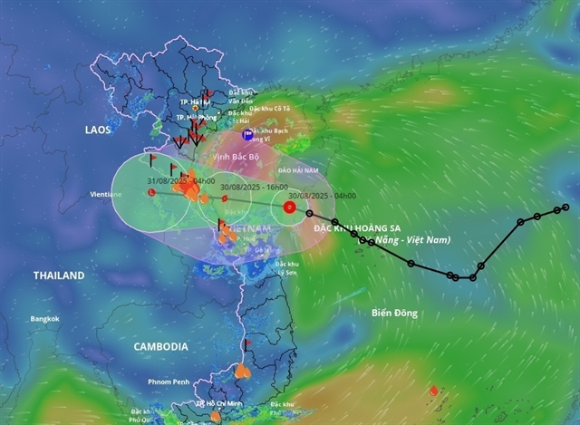 |
| Projected path of the typhoon over the next few days. — Photo nchmf.gov.vn |
HÀ NỘI — A tropical depression over the East Sea (internationally known as the South China Sea) has strengthened into Typhoon Nongfa, the sixth storm to form in the region this year, and is expected to strike central Việt Nam on Saturday evening.
At 7am on Saturday, the storm’s centre was located off the coast between Hà Tĩnh Province and Huế City, about 210km east of northern Quảng Trị Province.
Maximum sustained winds reached 62–74km/h, with gusts up to 102km/h, as it tracked west-northwest at around 20km/h.
The system is forecast to come ashore between Hà Tĩnh and northern Quảng Trị by Saturday evening, bringing strong winds and heavy rain before weakening into a tropical depression.
By Sunday morning, it is expected to move into central Laos and further downgrade into a low-pressure area.
Forecasters warned of rough seas in the western part of the northern East Sea, where waves of up to 4.5m are expected. Coastal waters from Thanh Hóa to Huế, including Hòn Ngư and Cồn Cỏ islands, may see winds of up to 74 km/h with gusts over 100km/h and waves as high as 5m.
Coastal flooding of 20–40cm is also possible from Nghệ An to Huế.
On land, winds are forecast to strengthen from midday Saturday, reaching 40–50km/h in coastal provinces from Nghệ An to Quảng Trị. Stronger conditions are expected in Hà Tĩnh and northern Quảng Trị, where gusts could peak 102km/h.
"Heavy thunderstorms accompanied by tornadoes may occur ahead of the typhoon’s direct impact," warned Mai Văn Khiêm, Director of the National Centre for Hydro-Meteorological Forecasting.
Rainfall between August 30 and 31 is forecast to reach 150–300mm in provinces and cities from Thanh Hóa to Huế, with some areas exceeding 500mm.
The northern midlands, Red River Delta and Đà Nẵng are expected to see 70–150mm, with localised totals above 300mm. — VNS
Society
 Society
 Society
 Society
 Society
 Society
 Society
 Society
 Society
 Society
 Society
 Society
 Society
 Society
 Society