 Environment

Việt Nam, Denmark issue joint statement on establishment of Comprehensive Strategic Partnership
1.
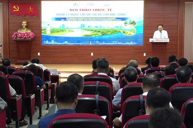 |
| Deputy Minister of Agriculture and Environment Lê Công Thành delivers a speech at the workshop. — Photo Nguyên Hạnh |
The event, titled 'Urban Flood and River Basin Management', was organised by University of Water Resources, the Việt Nam Water Resources Association and the Japan International Cooperation Agency (JICA).
Experts discussed flood management, regulating lakes, green infrastructure, forecasting and early-warning systems, as well as policies to improve cities’ resilience to natural disasters and climate change.
Deputy Agriculture and Environment Minister Lê Công Thành said in his opening remarks that urban flooding was no longer merely a problem of drainage systems within individual cities.
Extreme rainfall, upstream flows, river levels, tides, water-storage capacity, land use and urban planning are closely interconnected, he said. Flooding must therefore be managed through an integrated approach involving water resources, urban planning and disaster-risk governance.
Thành cited recent directives calling for a shift from simply responding to disasters to managing risks, and from dealing with consequences to preventing them at an early stage.
Planning should take account of drainage capacity, floodways, river management, construction standards and early-warning systems, he said.
A policy conclusion issued in July also called for a move away from fragmented management by sector and administrative boundaries towards integrated, interregional governance. Development should remain within ecological limits and include nature-based solutions, green infrastructure and infrastructure designed to withstand floods and climate impacts.
Aging systems
Around 90 per cent of drainage systems in cities are combined systems carrying both stormwater and wastewater, said Đặng Minh Hải, deputy head of the water resources engineering faculty at University of Water Resources.
Most were built 40 to 60 years ago and are increasingly unable to cope with extreme rainfall, he said.
Flooding varies by location. Mountain cities can be affected by heavy rain and river floods, lowland cities mainly by rainfall, while coastal cities face the combined effects of rain, tides and, in some areas, land subsidence.
Việt Nam recorded about 397 flood-prone locations covering about 925 hectares in 2024.
The figures show that the country cannot apply a single flood-control model nationwide. Solutions must reflect the natural characteristics of each city and river basin.
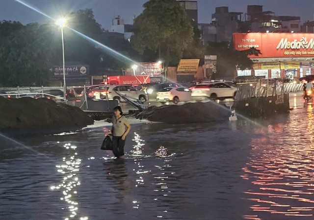 |
| A section of Cổ Linh Street in Hà Nội was inundated following heavy rain on the afternoon of July 31. — VNA/VNS Photo |
In Hà Nội for example, flooding is mainly caused by rain. Although the capital has implemented projects under its 2013 drainage plan, the capacity of pumping stations and the area of regulating lakes currently meet only about 30 per cent of the plan’s requirements, Hải said.
Recent heavy rains have exceeded the system’s design capacity, causing flooding at numerous locations. Hà Nội should reassess its drainage network and update its plans using new data, he said.
Authorities should also study ways to store rainwater in parks, schools and public spaces, alongside investment in sewers, retention lakes and pumping stations.
Basin-wide solutions
JICA expert Aoyama Yoshihiko said river-basin flood management should combine three measures, including controlling flows, storing water and improving disaster preparedness.
These include dredging and widening river channels, building reservoirs and retention lakes, and requiring new developments to manage runoff at its source. Authorities should also use flood-risk maps to identify vulnerable areas and prepare evacuation plans.
Experts urged Việt Nam to move from tackling isolated flood spots to managing risk across entire basins through integrated drainage, land-use planning and smart operations. Green solutions, such as permeable roads, rain gardens, storage tanks and floodable parks, should complement conventional infrastructure, while sensors, rain radar and cameras could strengthen forecasting and early warnings.
For the 2026–2035 period, they recommended prioritising institutional reform, reliable data and investment in high-risk basins. The long-term goal is to shift from passive flood control to proactive, climate-resilient risk management. — VNS
Environment
 Environment
 Environment
 Environment
 Environment
 Environment
 Environment
 Environment
 Environment
 Environment
 Environment
 Environment
 Environment
 Environment
 Environment