 Society


Trade promotion agency, Meta sign MoU to support Vietnamese SMEs' digital capabilities
1.
|
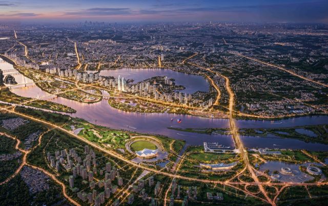
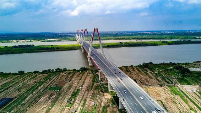
| A rendering of the Red River Scenic Boulevard. — VNA/VNS Photo |
By Hùng Võ and Ngọc Anh
HÀ NỘI — For centuries, Hà Nội has owed its existence to the Red River. Its sediment-rich waters formed the fertile alluvial plains on which the ancient capital of Thăng Long, modern-day Hà Nội, first emerged, sustaining rice-growing communities and enabling early trade routes across northern Việt Nam.
Over recent decades, however, the river has served less as the city’s lifeblood and more as a back boundary, a natural edge that urban planners have largely built around rather than integrated into development.
That is now set to change. Hà Nội’s authorities have unveiled an ambitious masterplan to reposition the Red River as the strategic spine of the capital’s development in the twenty-first century, a major shift that planners say is not simply about expanding urban space but rethinking how the city grows.
A city out of balance
In recent years, Hà Nội’s expansion has been largely westward, with commercial corridors, residential developments and administrative centres extending along the western axis. By contrast, large stretches along the riverbanks to the north and east have remained comparatively underdeveloped.
This has resulted in an uneven urban structure, with population density, traffic pressure and infrastructure strain concentrated in the historic core while significant areas along the river remain underused.
The new masterplan aims to address that imbalance. For the first time in the capital’s modern planning history, the Red River is being treated as a central development axis rather than a peripheral boundary, designed to link multiple growth poles and unlock investment in the north and east of the city.
The scale of the proposal underlines its ambition. The Red River Scenic Boulevard plan covers more than 11,400ha with a preliminary investment of nearly VNĐ737 trillion (US$28 billion), with implementation targeted through 2038.
Looking further ahead, Decision 2512 issued by the Hà Nội People’s Committee sets out a development framework to 2085, establishing nine major urban growth centres across the capital region.
Under this structure, the south bank will continue to anchor Hà Nội’s political, administrative, cultural and financial functions, preserving the historic core. The north bank is designated for economic development and international integration.
|
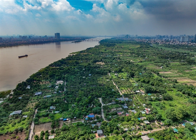
| Residential settlements and farming plots along the river's floodplain. — VNA/VNS Photo |
Satellite growth poles at Hòa Lạc, Sơn Tây, Phú Xuyên, Xuân Mai and Vân Đình-Đại Nghĩa would form a multi-functional urban network hosting a mix of international commerce, health care, logistics, education, sports facilities, cultural heritage tourism and ecological attractions.
A flood corridor
The enthusiasm surrounding Hà Nội’s riverside future exists alongside a more cautious strand of thinking among planners and engineers.
The Red River is not only a scenic asset but also the primary flood-discharge corridor for the entire Red River Delta in northern Việt Nam, a role that carries significant implications for any development along its banks.
Trần Huy Ánh, an architect and member of the Standing Committee of the Hanoi Architects Association, argues that the overriding purpose of any urban plan must be the quality of life it delivers to residents.
On the Red River, he says, this requires integrated, synchronised planning with human welfare and harmony with nature as non-negotiable priorities.
For years, the river was managed almost exclusively through a flood-control and dike-maintenance approach. Now that it sits at the centre of a development strategy, every intervention in the riverbed, on the sandbars and floodplains and along the discharge corridors must be assessed with a long-term perspective.
The floodplains flanking the river are not simply vacant land awaiting construction. In many areas, they function as natural ecological buffers that absorb flood energy, regulate water flow and reduce risk during extreme weather events.
As climate change drives more unpredictable and intense rainfall, planners are being urged to consider not only riverside development but also the resilience of the wider urban-ecological system linked to the river.
The existing reservoir cascade, Sơn La, Hòa Bình, Tuyên Quang and Thác Bà, has played an important role in moderating downstream flooding. However, over-reliance on this single layer of protection carries growing risks as infrastructure ages and precipitation patterns become more erratic.
Experts instead call for a multi-layered safety approach combining dikes and reservoirs with preserved flood corridors, ecological infrastructure, natural water-retention zones and early-warning systems.
Learning from abroad
International experience offers both cautionary examples and models worth studying. The Netherlands, after recognising the limits of total river control, shifted to its Room for the River programme, deliberately expanding natural floodplains to reduce pressure on hard infrastructure.
In Seoul, the restoration of the Cheonggyecheon stream, previously buried beneath an elevated expressway, demonstrated how shifting from hard infrastructure towards ecological recovery can improve urban microclimates, expand public space and increase natural water absorption.
The key lesson drawn from these cases is that large rivers operate according to their own hydraulic and topographic logic. Development along their banks must therefore be assessed on scientific grounds with a long-term view and cannot be reduced to questions of property value or urban expansion alone.
Vương Trung Thành, a researcher on multi-purpose integrated agriculture, advocates a development model along the Red River that balances economic growth with ecological preservation and climate resilience, moving away from maximum concrete coverage towards a layered, multi-functional landscape.
The riverside areas already contain assets that point towards that vision. The Nhật Tân flower-growing village and the Bát Tràng ceramic craft commune, along with vegetable farms along the riverbanks, dyke-side ecological trails and urban agricultural parks, represent a living combination of culture, community livelihoods and ecological function woven into the riverbanks long before any master plan.
|
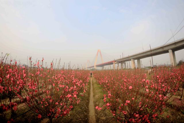
| Flowers in full bloom along the Red River floodplain at the Nhật Tân flower-growing village. — VNA/VNS Photo |
"This is not just about developing a scenic riverside corridor. It can become the foundation for a new development model in the era of green transition: growth without sacrificing safety; modernity without severing roots; expansion while preserving ecological foundations, cultural identity and the resilience of local communities," Thành says.
Hà Nội’s ambition for the Red River reflects a wider aspiration to position itself as a major twenty-first-century metropolis without losing what makes it distinctively itself. Proponents of the plan acknowledge that achieving this balance, modernising at pace while safeguarding ecological security and cultural depth, will be the defining challenge of the decades ahead.
With strong political commitment, integrated planning and broad social consensus, city planners argue that a river long treated as a problem to be managed could instead become the engine of Hà Nội’s most consequential era of growth. — VNS
Society
 Society
 Society
 Society
 Society
 Society
 Society
 Society
 Society
.jpg) Society
Society
 Society
 Society
 Society
 Society
 Society