 Environment

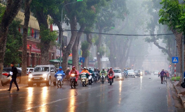 |
| In the northern central region, the strong northeast monsoon will bring cold temperatures with occasional light rain during Tết. In the central and southern central regions, scattered rain and showers are expected in the days leading up to Tết. — Photo baochinhphu.vn |
HÀ NỘI — According to the National Centre for Hydrometeorological Forecasting (NCHMF), the northern region of Việt Nam is expected to experience cold weather and drizzle during the Tết (Lunar New Year) holiday.
Deputy Director of the NCHMF Hoàng Phúc Lâm stated that in the period leading up to Tết, from January 17 to 25, northern Việt Nam will experience light morning fog, dry and sunny days, and continued cold temperatures. In central Việt Nam, from Thanh Hóa to Huế, the weather will be mostly cloudy with little to no rain and cold temperatures.
The region from Đà Nẵng to Bình Thuận will see cold weather at night and in the morning, while daytime temperatures will be mild and sunny. In the Central Highlands and southern Việt Nam, the nights and early mornings will be cloudy, with light fog or mist, but the days will be dry and warm without extreme heat.
During the main Tết period from January 27 to 31, northern Việt Nam will be affected by a northeast monsoon, resulting in cold weather, with severe cold in mountainous areas. The northeastern region may see some days with light rain or drizzle.
In the northern central region, the strong northeast monsoon during Tết will also bring cold temperatures with occasional light rain. In the central and southern central regions, scattered rain and showers are expected in the days leading up to Tết.
Over Tết, the eastern coastal areas of southern Việt Nam will experience tidal surges from January 30 to February 2. The highest tide levels during this period could reach 4.1 metres, potentially causing flooding in some coastal and estuary areas.
Weather patterns for 2025
In 2025, the ENSO phenomenon is predicted to return to a neutral state with a probability of 55-65 per cent over the three-month period from March to May. It is expected to remain in a neutral state for the rest of the year.
This means that while a La Niña event may persist briefly in early 2025, it may not last long enough to be classified as a full La Niña cycle. It is expected to gradually transition back to neutral conditions.
Based on these forecasts, Lâm highlighted several key weather and climate trends for 2025:
Under La Niña conditions, winds in the Pacific Ocean will strengthen, reducing convective activity near the central Pacific while increasing it over the western Pacific. As a result, Southeast Asia, particularly Indonesia and southern Việt Nam, may experience above-average rainfall in the early months of 2025. This could lead to unseasonal rains in southern Việt Nam during the dry season.
Regarding tropical depression activity, the number of storms in the East Sea (known internationally as South China Sea) is expected to be similar to the multi-year average, with storm formation beginning around June. The number of tropical storms and depressions affecting the East Sea and Việt Nam’s mainland is also expected to be in line with historical averages, with about 11 to 13 storms forming in the region and approximately five or six making landfall.
Heatwaves in 2025 are also expected to be on par with historical averages. Hot weather will likely begin in the southern and Central Highlands regions around early March, in the northwestern region and western parts of central Việt Nam around April, and in northeastern Việt Nam and coastal central regions from May onwards. However, the intensity and duration of heatwaves in 2025 are not expected to be as severe as in 2024.
Meanwhile, cold air activity in 2025 is expected to be in line with historical averages, meaning that severe cold spells could occur between January and March. Strong cold snaps could lead to widespread severe cold conditions, frost and freezing rain in northern mountainous areas.
"In addition, in 2025, the number of large-scale heavy rain events across the country is expected to be similar to the long-term average, with approximately 20 such events. These heavy rain episodes will likely begin in the northern region around June and gradually shift southward, ending in the central region around December," Lâm emphasised.
During the early dry season of 2025, saltwater intrusion in the Mekong Delta is expected to be higher than the historical average from February to April. This may impact livelihoods and agriculture in affected areas, but it is not expected to be as severe as in the dry seasons of 2015-2016 and 2019-2020.
From March to July 2025, drought and water shortages could affect some areas in the provinces of Phú Yên to Bình Thuận, as well as Kon Tum, Gia Lai and Đắk Lắk.
With the increasing intensity of strong storms due to climate change, the NCHMF will integrate storm monitoring and warning systems into digital platforms, providing information to the public and government agencies. Artificial intelligence (AI) will be applied in forecasting and early warning systems, initially focusing on storm tracking, heavy rainfall prediction and other rare weather events.
The use of AI will enhance the centre’s ability to analyse large datasets from various sources (observations, radar, satellites and numerical models) and improve short-term severe weather forecasting, including storm warnings three to six hours in advance. This will help enhance the accuracy of flood and landslide early warning systems. — VNS
