 Society

Madame Nguyễn Thị Lệ acknowledged as wife of war martyr Huỳnh Văn Quên
1.
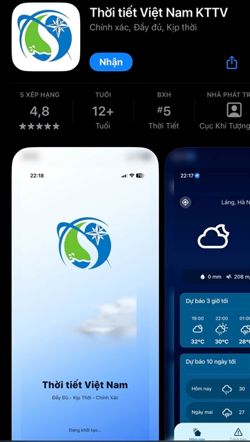 |
| The interface of Vietnam Weather KTTV mobile application. Photo baochinhphu.vn |
HÀ NỘI — Việt Nam has launched the Vietnam Weather KTTV mobile application, giving users access to real-time meteorological data and alerts on dangerous and extreme weather events as climate risks intensify.
The Việt Nam Meteorology and Hydrology Administration said the application comes amid increasingly complex climate change and more frequent and intense natural disasters, making public access to timely weather information more urgent than ever.
The application has been developed using accurate and up-to-date data sources, aiming to enhance the reliability of forecasts and better serve management, production and daily life.
Users can access official weather information from the State meteorological agency directly on their phones, with updates provided every 10 minutes.
The application offers high-quality performance and a large-scale data input system. Rather than relying solely on low-resolution global forecasting models, it integrates multiple in-depth local data sources.
The system records real-time field observation data from 2,600 automatic rain gauge stations nationwide.
In particular, data sources are further strengthened through rainfall estimation technology from eight modern weather radar stations, allowing rainfall patterns to be monitored every minute.
In addition, parameters on temperature, humidity, cloud and wind are continuously updated and combined with advanced numerical models, as well as forecast and warning bulletins on dangerous meteorological and hydrological phenomena issued by the National Centre for Meteorological and Hydrological Forecasting (NCMHF).
A key feature of the application is its highly sensitive system for warnings on natural disasters and hazardous weather.
All unusual weather events, from widespread thunderstorms, lightning strikes, landslides, flash floods, tropical depressions to strong winds at sea, are continuously updated from official data sources of the NCMHF and meteorological stations and prominently displayed on the main interface.
To optimise user protection, the application includes a real-time lightning warning feature. The system uses data from a lightning detection network to identify areas with strong electrical activity at an early stage, providing timely notifications to help users respond proactively to extreme weather situations.
Notably, the application has also integrated a real-time flash flood and landslide warning feature based on the user’s location.
Risk points are indicated through a system of icons mapped to specific geographical locations, clearly classified into three levels: medium, high and very high. With a simple tap on an icon, users can instantly access detailed information along with specific safety recommendations.
The application will be further updated and supplemented with rain and storm warning maps and other features to diversify its functions and meet growing public demand. — VNS
Society
 Society
 Society
 Society
 Society
 Society
 Society
 Society
 Society
 Society
 Society
 Society
 Society
 Society
 Society