 Sci-Tech

Youth-led initiative opens up opportunities for disadvantaged children
1.
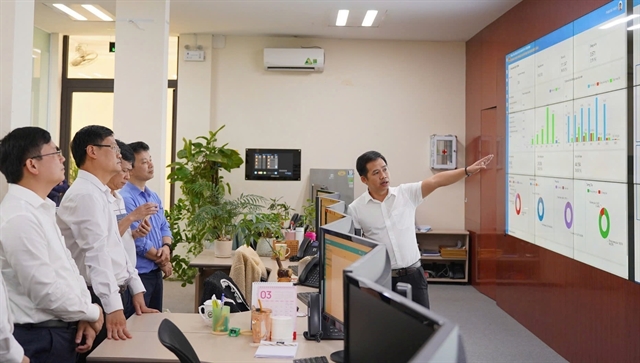 |
| The Smart Urban Operations and Monitoring Centre (IOC) in Huế City. — VNA/VNS Photo Văn Dũng |
HUẾ — From September 2026, as the rainy and flood season begins and continues through December, Huế City has integrated radar data into the Hue-S application, giving residents access to real-time information for disaster prevention and response.
The move is part of the city's efforts to step up the use of technology and digital transformation in disaster prevention and recovery, in line with the Politburo's Resolution No 57-NQ/TW on breakthroughs in science and technology development, innovation and national digital transformation.
The city's Smart Urban Operations and Monitoring Centre (IOC) has worked with the Sub-Department of Irrigation and Climate Change to integrate radar data into Hue-S.
With a smartphone connected to the internet and the Hue-S app installed, users can access information on rainfall, wind speeds, flooded areas and water levels in reservoirs and rivers across the city.
The radar function uses colours on a city map to show rainfall distribution across different areas.
This year, the city has also piloted a system to monitor and simulate the spread of flooding, develop flood maps and provide real-time smart warnings to support disaster response.
The technologies are designed to simulate and provide warnings of flooding, heavy rain and strong winds, as well as monitor changes in the water level of the Hương River by integrating data from cameras, Hue-S and specialised sources.
The city is also using artificial intelligence (AI), digital twins, hydrological and hydraulic models and big data to simulate flooding and support forecasting, early warnings, evacuation, safe route planning and disaster response operations at the IOC.
Huế is also modernising its monitoring systems and expanding the use of specialised software such as Vrain, Hue.vfass and Hue.vwind, along with multi-level monitoring models.
The city is expanding the use of remote sensing, satellite imagery, unmanned aerial vehicles (UAVs) and AI to analyse and forecast disasters and provide warnings of storms, heavy rain, flooding and thunderstorms, as well as support reservoir operations.
It is also maintaining and improving the Hue-S disaster warning system to provide timely information and help communities prepare for and respond to natural disasters. — VNS
Sci-Tech
 Sci-Tech
 Sci-Tech
 Sci-Tech
 Sci-Tech
 Sci-Tech
 Sci-Tech
 Sci-Tech
 Sci-Tech
 Sci-Tech
 Sci-Tech
 Sci-Tech
 Sci-Tech
 Sci-Tech
 Sci-Tech



.jpg)