 Society

HIIVE by fusion brings business and golf closer in Bình Dương
1.
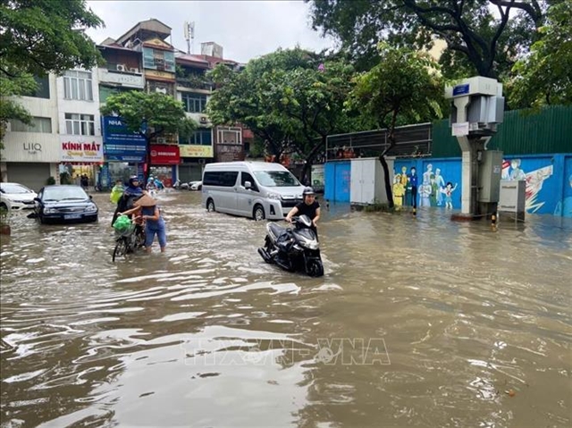 |
| A number of roads in Hà Nội are submerged due to heavy rains during the past days. — VNA/VNS Photo Nguyễn Thắng |
HÀ NỘI — Hà Nội has issued a level-one flood alert on two rivers, requiring relevant localities to strictly implement response regulations.
The requirement was released after prolonged heavy rains during the past days, leaving water levels on the Tích and Bùi rivers in Hà Nội exceeded the level one alert threshold at several hydrological stations.
According to observational data, at 6.20pm on Tuesday, the water level of the Tích River at the Kim Quan Hydrological Station in Thạch Thất Commune reached 6.81m, higher than the level one alert level of 6.80m.
On the Bùi River, at 5.40pm on Tuesday, the water level at the Yên Duyệt Hydrological Station reached 6.01m, higher than the level one alert level of 6.00m.
The Hà Nội Civil Defence Command on Tuesday evening issued two orders on a flood alert on the two rivers.
The communes and wards within the scope of the order for the Tích River include Sơn Tây, Phúc Thọ, Đoài Phương, Thạch Thất, Hạ Bằng and Tùng Thiện.
The communes within the scope of the order for the Bùi River include Xuân Mai, Phú Nghĩa, Trần Phú, Quảng Bị, Hòa Phú and Phúc Sơn.
The command requires communes and wards to strictly implement regulations when a level one alert is issued; to proactively monitor rain and flood developments and implement measures to ensure safety.
Alongside the flood developments on the rivers, prolonged heavy rain has increased the risk of landslides and ground subsidence in several suburban areas of Hà Nội.
According to a bulletin from the Northern Regional Centre for Hydro-Meteorological Forecasting, over a day from 7pm on Monday to 7pm on Tuesday, the Hà Nội area experienced moderate to heavy rain, with some places recording very heavy rain.
Some points recorded high rainfall amounts, including Ba Vì 103.3mm; Chợ Cháy 145.6mm; Miếu Môn 134mm; Phú Xuyên 133.4mm; Thanh Oai 165.2mm and Vân Đình 146.6mm.
Soil moisture models show that some areas in the capital city are close to saturation, above 80 per cent, or have reached saturation.
The meteorological and hydrological agency forecasts that some areas will continue to have rain, with cumulative rainfall generally 20–40mm.
The agency warns of the risk of landslides on slopes and ground subsidence in hilly suburban areas and along small rivers and streams. The warned areas include Ba Vì, Phú Cát, Suối Hai, Yên Bài, Yên Xuân, Kim Anh, Sóc Sơn and Trung Giã communes.
Landslides and ground subsidence could impact the environment, threaten people’s lives; cause localised traffic congestion, affecting vehicle movement; destroy civil infrastructure, economic activities and cause losses to production and socio-economic activities.
Localities and residents in riverside areas, low-lying zones, on slopes and places at risk of landslides should continue to closely monitor weather and hydrological forecasts, warnings and information from competent authorities; proactively implement safety measures; limit crossing deeply flooded areas, fast-flowing water or areas showing signs of landslides. — VNS
Society
 Society
 Society
 Society
 Society
 Society
 Society
 Society
 Society
 Society
 Society
 Society
 Society
 Society
 Society