 Society

De Beers Collaborates With Mabeo Studio And Botswana-Based Master Basket Weaver Shakunona Parata At Homo Faber 2026
1.
|
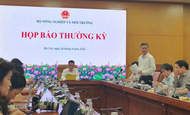
| The Ministry of Agriculture and Environment's regular press briefing takes place on Wednesday. VNS Photo Tố Như |
HÀ NỘI — The Ministry of Agriculture and Environment (MAE) is drafting regulations on electronic certificates for land use rights and ownership of assets attached to land, with a view to integrating them into the VNeID national digital identity app.
Speaking at the ministry's regular press briefing on Wednesday, Mai Văn Phấn, Deputy Director of the Department of Land Administration, said the department has drafted the content and format of the electronic certificate and held discussions with units under the Ministry of Public Security (MPS), including the C06 and C12 departments.
The aim is for electronic certificates to be integrated into VNeID once the necessary conditions are in place, making it easier for land users to manage their rights and carry out related transactions.
According to Phấn, completing the legal framework is a key requirement. The draft amended Land Law, currently under appraisal by the Ministry of Justice, is expected to provide for land registration and the issuance of certificates in both paper and electronic forms, with equal legal validity.
Administrative procedures for land-related matters must also be restructured to allow them to be processed entirely online.
“We are guiding 34 cities and provinces to select several procedures that are feasible to implement, with the ultimate goal of issuing electronic certificates to replace physical paper certificates,” Phấn said.
Alongside the legal framework, the national land database is another key foundation for electronic certificates. The data must be accurate, complete, regularly updated and capable of being connected and shared with relevant databases.

|
| Mai Văn Phấn, Deputy Director of the Ministry of Agriculture and Environment's Department of Land Administration speaks at the press briefing. VNS Photo Tố Như |
The Department of Land Administration is also coordinating with the MPS to authenticate information on individuals and legal entities, while working with the Tax Department under the Ministry of Finance to connect and share data for determining land users' financial obligations.
Regarding progress in developing the land database, Phấn said data had been established for more than 68 million land parcels nationwide. Of these, about 47.7 million parcels had met the ‘correct, sufficient, clean and live’ data requirements, while more than 20.5 million still need further supplementation.
Under Resolution No 21 promulgated by the Communist Party of Việt Nam, the national land database must be completed in 2026 in areas where data are already available. Areas requiring surveying, adjustment or new surveying are to be completed in 2027.
The Prime Minister has also set a target of completing at least 80 per cent of ‘correct, sufficient, clean and live’ data in areas where data are already available in 2026.
The current rate is about 70 per cent, with 47.7 million of the more than 68 million parcels meeting the requirements. The department representative said the 80 per cent target could be achieved at the current pace.
Resources, infrastructure remain bottlenecks
The land database is being developed across the 34 localities and 3,321 commune-level administrative units, creating substantial demand for human resources.
In addition to staff from land registration offices, local police forces and specialised agencies, some localities have mobilised students and teachers to help cross-check information. While specialised officials focus on data collection, support teams assist with verification to ensure consistency.
Funding is also a challenge in some localities, where allocated resources have so far met only part of the demand. The selection of consulting firms had previously been a bottleneck because open bidding was required despite tight implementation deadlines. National Assembly's Resolution No 193/2025/QH15 has provided an additional basis for addressing the issue.
Another requirement is to build a database covering all land parcels, including those under management that have not yet been granted land-use certificates. The Department of Land Administration has issued guidance on collecting information on these parcels to support State management.
Technological infrastructure at both central and local levels also needs further improvement to support data collection, storage, synchronisation and sharing. Data connectivity between the MAE and the MPS is also being further developed.
According to the department, authorities are currently prioritising the establishment and cleansing of data, while synchronisation, connectivity and data sharing will be carried out gradually as infrastructure is completed.
Completing the land database and developing electronic certificates are expected to provide a foundation for further digitising land-related procedures, reducing paperwork, improving information authentication and making it easier for people to carry out procedures and transactions involving land-use rights. — VNS
Society
 Society
 Society
 Society
 Society
 Society
 Society
 Society
 Society
 Society
 Society
 Society
 Society
 Society
 Society