 Society

SBV to curb property price inflation, enforce lending rate rules
1.
|
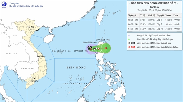
| Location of Typhoon Kujira in the East Sea at 5am Wednesday. — Photo courtesy of the National Center for Hydro-meteorological Forecasting |
HÀ NỘI — A tropical depression has intensified into a typhoon in the East Sea early Wednesday morning, but is not expected to affect Việt Nam's coastal areas and mainland.
This is the third typhoon to hit the East Sea this year, with the international name of Kujira.
According to forecasts from the National Center for Hydro-meteorological Forecasting, by 7am on Wednesday the typhoon was in the southeastern part of the northern East Sea, moving eastward at approximately three to five kilometres per hour.
By 4am on Thursday, it is likely to have reached the northwestern coast of Luzon Island in the Philippines and weakened into a tropical depression.
In the next 24 hours, the typhoon will cause strong winds and waves about two to four metres high in the northern part of the East Sea. Vessels operating in these zones are at risk of encountering thunderstorms and tornadoes.
On Việt Nam's mainland, moderate to heavy rain and thunderstorms are expected from Wednesday through Thursday night in the northern region and part of the central region stretching from Thanh Hóa to Quảng Trị Province.
There is a potential for high-intensity rainfall exceeding 100 milimetres within three hours in some places.
Heavy rain may cause flooding in low-lying areas, urban centres and industrial zones, as well as flash floods on small rivers and landslides on steep slopes.
"Heavy rainfall will gradually subside on Friday, but thunderstorms may still bring tornadoes, lightning, hail and strong gusts," said Nguyễn Hữu Thành, deputy head of the centre's Weather Forecasting Division.
Rain is likely to continue across the northern provinces of Cao Bằng, Lào Cai, Tuyên Quang, Thái Nguyên, Điện Biên, Sơn La and Phú Thọ, with risk of flash floods and landslides. — VNS
Society
 Society
 Society
 Society
 Society
 Society
 Society
 Society
 Society
 Society
 Society
 Society
 Society
 Society
 Society