 Society


Overseas diplomatic missions urged to provide stronger support for localities to unlock international partnerships
1.
|
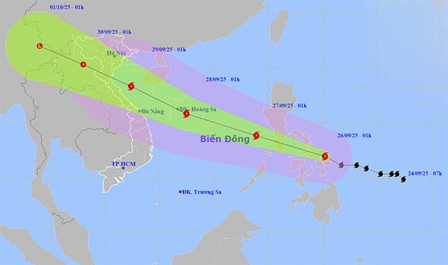
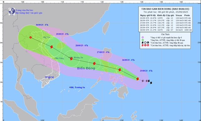
| Bualoi's current and projected path. Photo from the NCHMF |
HÀ NỘI — Typhoon Bualoi, the 10th storm to enter the East Sea (internationally known as the South China Sea) in 2025, is moving quickly west-northwest and is forecast to bring strong winds, rough seas and widespread heavy rain to Việt Nam’s central and northern regions over the coming days.
At 1am on September 26, the storm’s centre was located at 11.9°N, 125.2°E over the central Philippines, according to the National Centre for Hydrometeorological Forecasting (NCHMF). Maximum sustained winds near the centre reached level 11 (103–117 km/h), with gusts up to level 14. The storm was travelling west-northwest at 25–30 km/h and is expected to enter the East Sea tonight.
By 1am on September 27, the storm’s centre is forecast to be at 13.8°N, 118.9°E, with winds at level 11, gusting to level 14. By 1am on September 28, it is expected to strengthen further to level 12, gusting to level 15, over the central East Sea. In the early morning of September 29, the storm is forecast to approach the north-central coast, centred at 18.3°N, 107.4°E, with winds at level 12–13, gusting to level 16, before gradually weakening.
From the September 26 evening, the northeastern and central East Sea will experience strong winds at levels 6–7, rising to levels 8–9. Areas near the storm’s centre will face winds at levels 10–12, gusting to 15, with waves reaching 5–7 metres and very rough seas. Vessels operating in these dangerous zones face high risks of thunderstorms, whirlwinds, strong winds and high waves.
On land, scattered showers and thunderstorms were recorded on the morning of September 26 from Hà Tĩnh to Đà Nẵng and in the Central Highlands. Rainfall was heavy in some places, with Vĩnh Tú (Quảng Trị) recording over 80mm, Quan Tượng Đài (Huế City) 185.6mm, and Hồ Thái Xuân (Đà Nẵng) 83.6mm.
In the next 24 hours, heavy rainfall is expected to expand into the northeastern region and southern Phú Thọ, with totals of 30–70mm and some places exceeding 150mm. Rain intensity may surpass 100mm in just three hours. Meanwhile, the northwest, Thanh Hóa to Đà Nẵng, the Central Highlands and the south will continue to experience scattered showers and thunderstorms, with localised totals above 80mm. From the afternoon of September 27, rain in the northeast and southern Phú Thọ is forecast to gradually ease.
The meteorological agency warns that prolonged heavy rain may cause flooding in low-lying, urban and industrial areas, as well as flash floods in small rivers and streams and landslides in mountainous regions. Thunderstorms could also bring whirlwinds, lightning, hail and strong gusts, adding further risks to communities and infrastructure. — VNS
Society
 Society
 Society
 Society
 Society
 Society
 Society
 Society
 Society
 Society
 Society
 Society
 Society
 Society
 Society