 Society


Việt Nam remains steadfast in principles, flexible in implementing foreign policy in Middle East
1.
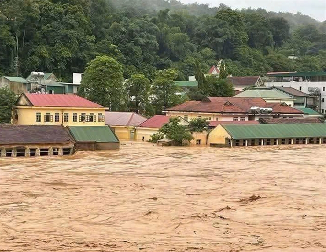 |
| Houses in Nghệ An submerged in floodwaters following Typhoon Wipha. — VNA/VNS Photo |
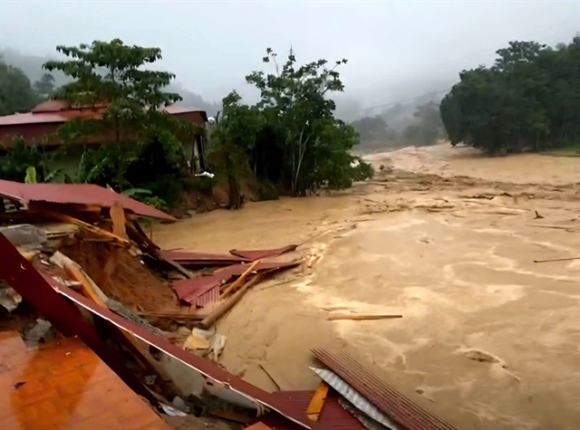
HÀ NỘI — Typhoon Wipha (designated as Typhoon No. 3 in Việt Nam) has caused severe and widespread damage across the northern and north-central regions, with Nghệ An Province suffering the most devastating impacts.
By the morning of July 23, the storm system had crossed into Laos and dissipated, but its destructive footprint remained acutely visible across a vast swath of the country.
Nghệ An was the hardest-hit province. As of midday on July 23, the province recorded one death, one person missing and four injuries due to flooding and storm-related incidents.
The missing individual was a 70-year-old woman from Nậm Cắn Commune who was swept away by a surging stream while returning home with her daughter. The daughter survived, but difficult terrain, heavy rainfall and strong upstream currents have hampered search operations.
Damage to property and livelihoods has been extensive. Initial reports indicate that at least 161 homes were damaged or lost their roofs and more than 3,200 houses were submerged under floodwaters.
Torrential rains also wiped out rice fields, livestock, poultry and personal assets across numerous communes, severely affecting the livelihoods of thousands.
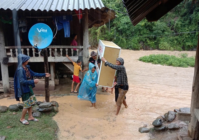
The storm prompted emergency evacuations on a large scale. Nearly 1,200 households across the province were evacuated or moved to higher ground, with 528 families in Mường Xén Commune relocated overnight on July 22.
Other border communes such as Mỹ Lý, Thông Thụ and Tri Lễ also organised evacuations for hundreds of residents.
In Nhôn Mai commune, 21 villages were cut off completely, while in Mường Xén, nine villages were inundated with up to to 3.5m of floodwater. Hundreds more households in western Nghệ An faced similar conditions, with many remaining inaccessible as of July 23.
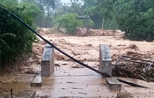
Nghệ An’s transportation network was virtually paralysed. Major roads such as National Highway 7A and Provincial Road 543D were heavily flooded and damaged by landslides at dozens of points, cutting off access between key regions and remote communes.
According to the provincial Department of Transport, by the afternoon of July 22, 29 locations across the province experienced full traffic blockages due to flooding or talus landslides.
Three bridges collapsed due to flash floods, including the main bridge across the Nậm Mộ River leading to the Vạn Cửa Rào temple, which was destroyed overnight on July 22.
Additionally, two pedestrian bridges in Nhôn Mai and Mường Quàng Communes were washed away, isolating entire communities from external access.
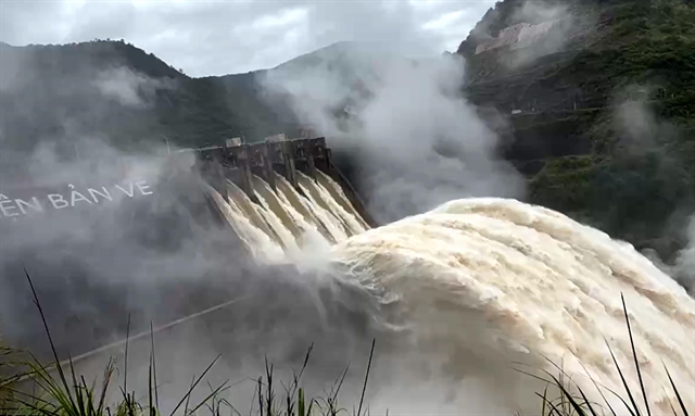
A major concern during and after the storm was the Bản Vẽ Hydropower Reservoir, which received extreme flood inflow volumes. At 2am on July 22, the inflow surged to 12,800cb.m/s, surpassing the designed threshold of 10,500cb.m/s – reaching a level that has only a .02 per cent probability of occurring.
Authorities opened the floodgates at 4pm that day, after the reservoir’s upstream water level had climbed to 191.22m, nearly breaching safe operational limits.
By 7am yesterday, the inflow had lowered to 7,347cb.m/s, but the situation remained tense as the reservoir continued releasing water downstream at a rate of 4,351cb.m/s.
Facing this escalating crisis, more than 700 personnel from the military, police and militia forces in the province were mobilised to support search, rescue and evacuation efforts.
Amphibious vehicles, canoes and armoured transport were deployed to remote villages, especially to assist vulnerable populations such as the elderly and children.
The Nghệ An Provincial People’s Committee dispatched three emergency working groups led by its leaders to high-risk districts, including Kỳ Sơn, Tương Dương and Con Cuông, to directly oversee local flood response operations.
Significant damage to river and coastal dikes was also recorded. Landslides, erosion and sinkholes were reported along several dike sections in Thanh Hóa and Ninh Bình, while Hà Nội authorities detected new cracks and expanding fissures in critical dike segments along the Hồng and Cầu Rivers.
In Hải Phòng, a portion of the Thái Bình River dike burst under pressure from both stormwater and high tides.
A Ministry of Agriculture and Environment report showed that across the northern region and down to Hà Tĩnh, there are 4,487 reservoirs, most of which were nearing capacity. Ninety-one reservoirs were undergoing repairs or upgrades at the time of the storm.
While Nghệ An was the hardest hit, many other provinces suffered significant losses.
Thanh Hóa reported over 19,000ha of flooded rice fields, 251 damaged homes and extensive road damage caused by landslides along Highways 15C and 16, which displaced more than 20,000cb.m of debris.
Ninh Bình suffered the most extensive agricultural damage, with 74,017ha of submerged rice paddies. Hưng Yên also recorded over 26,000ha of flooded fields, with river levels exceeding historical peaks.
Quảng Trị, Phú Thọ and Lạng Sơn reported dozens of damaged houses and scattered infrastructure losses. In Lâm Đồng, storm-induced tornadoes injured two people, whereas in Điện Biên, flash floods destroyed the Pa Thơm suspension bridge, injuring three.
On July 22, Prime Minister Phạm Minh Chính issued an urgent order directing the Ministry of National Defence, Ministry of Public Security, Ministry of Agriculture and Environment and other relevant bodies to coordinate emergency response, particularly in the Cả River basin.
The Ministry of Agriculture and Environment also issued a directive requesting Nghệ An and Hà Tĩnh Provinces to urgently implement measures to ensure dike and dam safety, including strict patrols, on-site reinforcements and adherence to existing emergency protocols.
The General Staff of the Vietnam People’s Army issued Directive 4214 ordering Military Region 4, the Air Force Command, Corps 18 and the Border Guard Command to remain on high alert, position equipment at the ready and prepare for search-and-rescue operations by land, river or air.
As clean-up and rescue operations continue, the National Centre for Hydrometeorological Forecasting issued a new warning on July 23.
A tropical depression has formed near the East Sea (internationally known as the South China Sea), northwest of Luzon Island ofthe Philippines.
The system is expected to strengthen and move west-southwest at 10–15km/h, with maximum sustained winds of 39–49km/h, gusting up to 62-74km/h.
Forecasts suggest it could intensify into a storm in the next few days and move toward the northern East Sea, with disaster risk level 3 assigned to the affected maritime area. Vessels operating in this zone are at risk of strong winds, rough seas and large waves.
As Nghệ An and other provinces begin the arduous task of recovery, authorities remain on high alert for continued weather threats in the days to come.
The response to Typhoon Wipha has underscored the importance of early warning systems, inter-agency coordination and local preparedness in mitigating natural disaster impacts. — VNS
Society
 Society
 Society
 Society
 Society
 Society
 Society
 Society
 Society
 Society
 Society
 Society
 Society
 Society
 Society