 Environment

Businesses continue to seek cheaper financing as lending rates remain high
1.
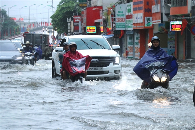 |
| An Biên Ward in Hải Phòng City is flooded by heavy rain over the past few days. — VNA/VNS Photo |
Associate Professor Mai Văn Khiêm, director of the National Centre for Hydro-Meteorological Forecasting, speaks to Vietnam News Agency about the development of ongoing torrential rainfall in the north.
Heavy rain over the past few days has affected most regions, especially in the north, causing widespread flooding and significant damage. Based on your experience in meteorological forecasting, what caused this rainfall and is it unusual for mid-May?
Since the evening of May 16, the northern part, particularly the northeastern region, has experienced widespread showers and thunderstorms due to a strong southeast wind convergence zone extending from the surface to an altitude of around 3,000 metres.
This weather system has carried large amounts of moisture from the sea inland. Combined with unstable atmospheric conditions, it has formed many rapidly developing convective cloud systems.
Several areas recorded extremely intense rainfall within a short period. Minh Long Commune in Cao Bằng Province received 117.4 mm of rain in just one hour on the evening of May 16, while Hạ Long City in Quảng Ninh Province recorded about 82 mm within one hour on the morning of May 17.
Such concentrated rainfall over a short period caused localised flooding in many urban and low-lying areas.
May is typically a transitional season in the northern region, often accompanied by moderate to heavy rain and strong thunderstorms. However, what is notable about this event is the occurrence of highly localised extreme rainfall with exceptionally high intensity over a short duration.
Recent developments indicate a dangerous weather pattern that has become increasingly frequent in recent years, posing major challenges for urban flood prevention, flash flood control and landslide mitigation.
What is the forecast for rainfall and flooding in the coming days?
From now until around May 22, northern and north-central regions, including Thanh Hóa, Nghệ An and Hà Tĩnh provinces, will continue experiencing widespread showers and thunderstorms.
In addition to the humid southeast wind convergence zone, an upper-air wind convergence area at around 5,000 metres moving from upper Laos will further increase the likelihood of widespread heavy rain and strong thunderstorms.
During thunderstorms, people should remain alert for tornadoes, whirlwinds, lightning, hail and strong gusts.
There is also a high risk of flash floods and landslides in mountainous and midland areas in the northern region and western parts of Thanh Hóa and Nghệ An provinces.
Urban areas should also watch for localised flooding caused by high-intensity rainfall.
El Niño-Southern Oscillation (ENSO) is currently in a neutral phase, with sea surface temperature anomalies in the central equatorial Pacific Ocean’s NINO3.4 region reaching 0.4 degrees Celsius above average in early May. Given this trend, what types of natural disasters should people prepare for?
Sea surface temperatures have risen rapidly over the past month. In early April 2026, sea surface temperature anomalies were below 0.2 degrees Celsius, but increased to above 0.4 degrees Celsius by early May.
According to the latest ENSO forecasts updated in mid-May 2026, El Nino is developing rapidly and earlier than previously predicted. Its intensity is also expected to be stronger than earlier forecasts suggested.
Specifically, El Nino conditions are likely to begin during the June-August 2026 period with a probability exceeding 90 per cent and are expected to persist through late 2026 and early 2027, reaching the highest probability of 96 per cent during December 2026-February 2027.
Notably, the probability of a very strong El Nino event has increased to around 40 per cent, compared with 25 per cent in previous forecasts.
This is a particularly concerning signal because strong El Nino events are often associated with many extreme weather phenomena.
Under this scenario, average temperatures nationwide are expected to remain above normal, with more frequent and intense heat waves than in 2025.
Rainfall is likely to be below average during the 2026 dry season, particularly from late 2026 to early 2027, with deficits commonly ranging from 25 per cent to 50 per cent. The rainy season may also end earlier than usual.
However, even during El Nino years, when total rainfall is generally lower than average, localised extreme downpours can still occur within short periods, potentially triggering flash floods, landslides and urban flooding.
Storm and tropical depression activity in the East Sea may be below average, but authorities still need to prepare for strong storms with complicated paths and significant impacts over short durations.
Given these meteorological and hydrological trends, what recommendations does the National Centre for Hydro-Meteorological Forecasting have for authorities and the public to improve disaster risk management, especially regarding dangerous weather phenomena such as thunderstorms, tornadoes, lightning, hail and strong winds?
As weather and climate conditions become increasingly extreme, we believe it is essential to emphasise early preparedness, early warning and early action.
In the short term, local authorities should closely monitor heavy rainfall events in May, review high-risk areas prone to flash floods, landslides and urban flooding, and proactively prepare response measures.
In the longer term, with the risk of a strong El Nino developing in the second half of 2026, ministries, sectors and localities should promptly formulate plans to cope with drought, water shortages and saltwater intrusion. Reservoir operations should also be reviewed to ensure water and energy security for the dry season from late 2026 to early 2027.
Residents are advised to regularly update weather forecasts and warnings issued by meteorological agencies, actively take precautions against thunderstorms, tornadoes, lightning, hail and strong winds, and remain vigilant against localised extreme rainfall even during El Nino conditions.
The National Centre for Hydro-Meteorological Forecasting will continue closely monitoring ENSO developments, heavy rain, storms, drought and water resources, and provide timely forecasts and warnings to support authorities at all levels.
Real-time warnings on thunderstorms, lightning, flash flood and landslide risks are available on the Viet Nam Meteorological and Hydrological Administration’s websites at http://hymetnet.gov.vn/radar/ and https://luquetsatlo.nchmf.gov.vn and through daily bulletins. — VNS
Environment
 Environment
 Environment
 Environment
 Environment
 Environment
 Environment
 Environment
 Environment
 Environment
 Environment
 Environment
 Environment
 Environment
 Environment