 Environment

Chinese tech firm Tenfy eyes new investment in Tây Ninh
1.
|
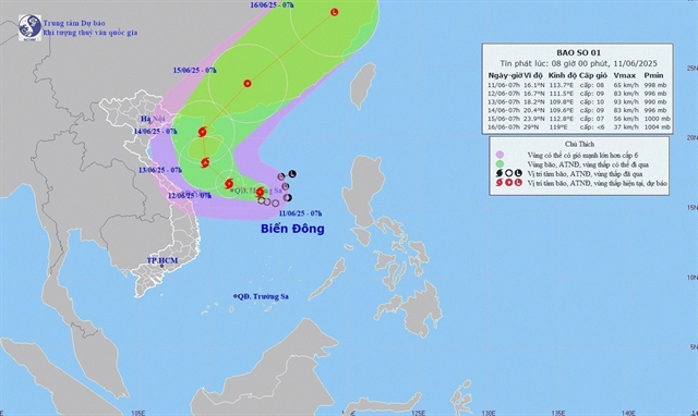
| A map showing the expected path of the first typhoon of the year, named WUTIP, on Wednesday morning. — Photo nchmf.gov.vn |
HÀ NỘI — A tropical depression over the eastern part of the Hoàng Sa (Paracel) archipelago has intensified into the first typhoon of this year, named Wutip, on Wednesday morning.
The typhoon is forecast to bring torrential rains to the central and Central Highlands regions between Wednesday evening and Friday.
Director of the National Centre for Hydrometeorological Forecasting Mai Văn Khiêm said that as of 7am on Wednesday, the typhoon's eye was located at approximately 16.1 degrees North and 113.7 degrees East, over the eastern waters of the Hoàng Sa (Paracel) archipelago.
The strongest winds near the eye of the typhoon reached level 8 on the Beaufort scale (62–74 km/h), with gusts up to level 10.
Wutip is now moving slowly in a west-northwesterly direction at a speed of around 5–10 km/h.
Due to the influence of the typhoon, the northern part of the East Sea — including the waters around the Hoàng Sa (Paracel) archipelago — is expected to see thunderstorms and strong winds of levels 6–7, later increasing to levels 8–9, with gusts reaching level 11. Waves are expected to rise to between 2.5–4.5 metres, creating very rough sea conditions.
In the southern and southern central parts of the East Sea, including the waters around the Trường Sa (Spratly) archipelago, southwesterly winds will strengthen to level 6, occasionally reaching level 7, with gusts of levels 8–9. Waves may rise to 2-4m, causing rough seas.
The meteorological agency has issued warnings for all vessels operating in the above-mentioned hazardous areas, advising of the risk of thunderstorms, squalls, strong winds and high waves.
Between Wednesday evening and Friday, the central region is also forecast to receive heavy to very heavy rainfall, with expected accumulations ranging from 100–300mm, and isolated areas potentially exceeding 450mm.
The northern part of the Central Highlands is expected to experience moderate to heavy rain and thunderstorms, with some areas receiving very heavy downpours of 70–150mm and over 200mm in certain locations.
Starting Saturday, rainfall in the affected regions is forecast to decrease.
Preparedness
Prime Minister Phạm Minh Chính on Tuesday issued an Official Dispatch No 86/CĐ-TTg, instructing ministries, agencies and local authorities to proactively prepare for heavy rainfall caused by the then-tropical depression.
He requested that chairpersons of Provincial and Municipal People’s Committees closely monitor the storm’s development and rainfall patterns and implement response measures suitable to local conditions.
Key priorities include ensuring the safety of vessels and sea-going vehicles, including tourist boats; evacuating residents in high-risk areas prone to landslides, flash floods or severe flooding; and securing critical infrastructure, construction sites, industrial parks, urban areas and low-lying production zones.
In a related move, the Ministry of Agriculture and Environment on Tuesday also urged coastal provinces and cities from Quảng Ninh to Khánh Hòa provinces to manage and control the departure of vessels to sea, and to account for all vessels and inform their owners and captains of the storm’s position, trajectory and potential risks, enabling them to steer clear of dangerous areas or seek safety.
Relevant ministries, sectors and localities have been asked to mobilise emergency response teams and resources for search and rescue operations if needed.
The Vietnam News Agency, Việt Nam Television, Voice of Việt Nam, coastal radio systems and all media outlets, both national and local, are being told to continually update information regarding the storm's development.
This will help keep local authorities, vessel operators and the public fully informed and prepared.
All relevant units must maintain a round-the-clock duty roster and report regularly to the Ministry of Agriculture and Environment via the Department of Dike Management and Natural Disaster Prevention and Control. — VNS
Environment
 Environment
 Environment
 Environment
 Environment
 Environment
 Environment
 Environment
 Environment
 Environment
 Environment
 Environment
 Environment
 Environment
 Environment
.jpg)