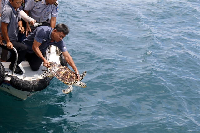
 Environment
Vũ Hạ keeps sedge mat craft alive
1.
The city’s unique natural features with a dense network of rivers and lakes creates the distinctive geographical and beautiful, characteristics of the capital city.
|
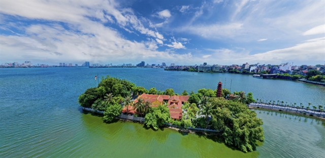
| West Lake is one of the largest of Hà Nội. Photo ktdt.vn |
HÀ NỘI – The capital city of Hà Nội needs to promote its rivers and lakes to develop the capital into a "civilised - modern – green-smart" city.
The city’s unique natural features include a dense network of rivers and lakes, with an average density of approximately 0.5 - 1.0 km of river per sq.km, creating a geographically distinctive and beautiful city.
The Hồng (Red) and Đà river are the two major rivers flowing through Hà Nội.
According to Dr. Lê Ngọc Anh, director of the Institute for Socio-Economic Development Research in Hà Nội, these are the two largest rivers in northern Việt Nam, holding significant value in the socio-economic life, particularly in connection with the thousand-year history of establishing and defending the nation, associated with the culture of the Bắc Bộ plain, linking the culture of Thăng Long and the culture of Xứ Đoài.
Along with the river system, another unique feature is that Hà Nội also possesses a diverse system of lakes, with approximately 115 inner-city lakes and 12 large suburban lakes, covering over five hectares and that excludes ponds.
In particular some lakes, such as Hồ Tây (West Lake), Hoàn Kiếmand Trúc Bạch, hold significant cultural value, reflected in many historical records and literary works.
Currently, many cultural spaces are being effectively exploited such as the cultural spaces of Hồ Tây and Hoàn Kiếm Lake.
The lakes have an important urban landscape values, serving to regulate surface waters and drainage and are also used for wastewater discharge for residential areas. The water from these lakes is also used for agricultural production and aquaculture.
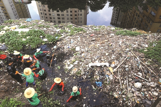
However, due to the impact of urbanisation and population pressure, many rivers and lakes in Hà Nội are gradually deteriorating and becoming polluted. Some lakes are shrinking in size due to encroachment and land reclamation for construction, Ngọc Anh said.
The situation of discharging waste and domestic wastewater directly into rivers and lakes is causing severe pollution and many lakes are silted due to natural sedimentation processes and lack regular dredging.
The exploitation of water resources and economic development around the lakes has not followed strict planning regulations.
The river sections flowing through urban areas, concentrated residential areas and production and business areas in the suburbs have led to deteriorating water quality and serious pollution, especially to the Tô Lịch, Kim Ngưu, Lừ, Sét, Nhuệ and Đáy rivers.
Preserving and creating unique spaces
Recognising the importance of Hà Nội's rivers and lakes, the Capital Plan stresses the issue in its breakthrough phase in urban, environmental and landscape development with the idea of exploiting the unique landscape and environmental values of Hà Nội to develop the capital.
Specifically, before 2030, the plan aims to revitalise the inner-city rivers, strictly protect the lakes and water spaces and exploit the landscape advantages of the river and lake system, to create unique ecological spaces for the capital.
This is also identified as a top priority task when implementing the Capital Planning.
The Hồng River is given particular attention, as highlighted in Conclusion No. 80-KL/TW: "Researching the development plan for the Hồng River axis to make the Hồng River truly the development centre of the capital, with harmoniously distributed ecological, cultural, historical, green and modern urban spaces along both banks of the Hồng River, contributing to creating a new face for the civilised - modern capital, with the goal of making the development space of the Hồng River a 'new development symbol' of the capital.
“In addition, it is necessary to research and include in the planning and planning decisions to effectively use the land fund on both sides of the Hồng River and Đuống River for socio-economic development, especially for tourism and service development."
According to Ngọc Anh, exploiting and promoting the potential of Hà Nội's river and lake system to be specifically laid out in the content of development plans for industries and fields, particularly in developing cultural and tourism industries.
This can be seen in the exploitation of tourism corridors along rivers such as the Hồng River, Tô Lịch River, he said.
The city should build new cultural parks, recreational and sports areas associated with the scenic axes of the Hồng River, Tô Lịch River, Nhuệ River and Tích River and expand pedestrian spaces in areas such as Hoàn Kiếm Lake, areas of the Old Quarter, Hồ Tây, Văn Miếu, Ngọc Khánh Lake, Thiền Quang Lake, Sơn Tây Ancient Citadel, along the cultural space axis of the Hồng River, the director suggested.
Forming cultural and artistic exhibition spaces on both sides of the Hồng River, constructing public art works with cultural symbols of the capital, highlighting spaces in the northern, western and southern gateway cities of the Hồng River, Đáy River, Tô Lịch River scenic axes should be made a priority.
Capital Planning has also focused on developing a waterway transport system, which was the main mode of transportation of Hà Nội in history due to its many river advantages, but that has now faded.
Therefore, it identifies waterway transport, including both freight and passenger transport, especially tourist transport, as an important and unique mode of getting visitors around the capital.
Waterway transport routes connecting regions contribute to expanding the capital's development space towards the sea and also connecting the Red River Delta Region with the Northern Midlands and Mountainous Region through the Hồng River, Đuống River and Đà River and expanding and developing urban space and unique tourism routes not only through outer-city rivers such as the Cà Lồ River and Thiếp River, but also within the city such as the Tô Lịch River and Tích River.
In addition, the Capital Planning focuses on the planning of the river and lake system to ensure water security, storage, regulation and distribution of water resources for various needs fairly and reasonably.
The city will exploit and use water resources efficiently and sustainably associated with protecting and developing water resources from the river and lake system to meet the water needs for socio-economic development and urban landscape ensuring national defence, security and environmental protection, he said. VNS
Environment
 Environment
 Environment
 Environment
 Environment
 Environment
 Environment
 Environment
 Environment
 Environment
 Environment
 Environment
 Environment
 Environment
 Environment