 Economy


PM calls Angkormilk project proof of Vietnamese businesses’ success in Cambodia
1.
|
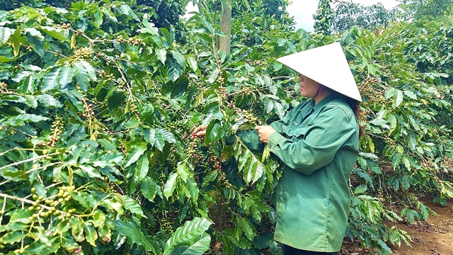
| A farmer is harvesting coffee in Quảng Trị Province. Việt Nam is speeding up the development of a 2020 forest boundary map to help exporters comply with the European Union Deforestation Regulation. — VNA/VNS Photo Nguyên Linh |
HÀ NỘI — Việt Nam is speeding up the development of a 2020 forest boundary map to help exporters comply with the European Union Deforestation Regulation (EUDR) and reduce risks for key export sectors such as coffee, rubber and timber when accessing the EU market.
At a webinar organised on May 29 by the Forestry EUDR Network, Trương Tất Đơ from the Forestry and Forest Protection Department under the Ministry of Agriculture and Environment said the core requirement of the EUDR is that commodities placed on the EU market must not be linked to deforestation after December 31, 2020, and must comply with the laws of the producing country.
To demonstrate compliance, producers must first provide the geographical coordinates of production plots and compare them against a 2020 forest boundary map to determine whether the area is associated with deforestation, Đơ said.
He noted that because the EUDR uses December 31, 2020, as its reference date, maps created after that point cannot serve as the basis for compliance assessments. Any change in forest status after the cut-off date could be considered a violation, even if land-use conversion was authorised by competent authorities
If Việt Nam does not establish its own forest reference dataset, European importers will continue relying on global forest-cover databases to assess compliance for Vietnamese exports, which might result in inaccuracies when applied to local production conditions.
Đơ cited examples from coffee-growing areas where shade trees are commonly integrated into farming systems. Such areas can sometimes be misclassified as forests in satellite imagery, creating a risk that export shipments could be wrongly identified as violating anti-deforestation rules.
“If we do not have our own data, importers will use international datasets for verification, which may place Vietnamese exporters at a disadvantage,” he said.
To address the issue, Việt Nam is developing a forest boundary dataset that combines multiple sources, including provincial forest-status maps in 2020, remote-sensing data, multi-temporal satellite imagery and international reference datasets such as UMD/GLAD and the European Commission’s Joint Research Centre (JRC).
Experts said the mapping process consists of six stages: standardising 2020 forest data, analysing land-cover changes through remote sensing, cross-checking with international datasets, conducting multi-source reliability assessments, validating results at the local level, and publishing the information through an online platform.
The results are categorised into three groups.
Green areas represent locations where all data sources are consistent. Yellow areas indicate discrepancies requiring further verification, while red areas identify higher-risk zones directly linked to EUDR-sensitive commodities such as coffee, rubber and timber.
Data from 13 provinces that have completed reviews show that green areas account for about 54.2 per cent of the mapped area, yellow areas 45 per cent, and red areas 0.8 per cent. Local authorities have already conducted field verifications for all red-zone locations.
Tô Xuân Phúc, a policy analyst at Forest Trends, said the most significant benefit of the mapping effort is enabling Việt Nam to develop its own data infrastructure rather than relying entirely on external systems.
The map is not intended to create additional procedures or regulatory barriers but to safeguard the legitimate interests of Việt Nam’s export industries, he said.
|
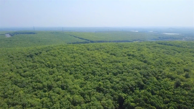
| A rubber forest in Đồng Nai Province. The Forestry and Forest Protection Department will publish Version 1.0 of the map on its website after receiving review results from all 34 participating provinces and cities. — VNA/VNS Photo Nhật Bình |
The Forestry and Forest Protection Department will publish Version 1.0 of the map on its website after receiving review results from all 34 participating provinces and cities.
The database will remain open for further updates, following a model similar to that used by the EU’s JRC, with the aim of improving accuracy and reliability in subsequent versions.
To date, 19 of the 34 provinces and cities have submitted complete datasets while the remaining localities are continuing verification before finalising submissions.
Experts pointed out that the biggest challenge is the lack of 2020 forest-status data in some localities, beside uneven technical capacity and concerns over discrepancies with previously published map.
To support local authorities, technical teams have developed a free review toolkit based on open-source platforms, integrating Sentinel, Planet and Google Earth imagery to facilitate rapid verification of suspected plots.
According to Phạm Ngọc Hải from the Forest Inventory and Planning Institute, international datasets such as Global Forest Change (GFC) and JRC products should be treated as reference layers rather than legally decisive evidence.
Hải said local data will remain the determining factor when assessing yellow and red zones because local authorities possess detailed information on land allocation records, cultivation histories and field inventories.
Phạm Văn Duẩn from the Institute of Forest Ecology and Environment said current processing methods prioritise local datasets combined with multi-temporal remote-sensing analysis, while international datasets are used mainly for comparison.
In Version 1.0, some yellow zones will remain because there is not yet sufficient evidence to reach definitive conclusions. Future updates will continue to prioritise local data and multi-temporal satellite imagery, he said.
Experts warned that EUDR-related risks remain relatively high for products such as coffee, rubber and timber, particularly in the Central Highlands, underscoring the need for further data verification.
Ministry of Agriculture and Environment officials said the EU is expected to establish a legal data repository for EUDR implementation in June 2026.
Việt Nam’s forest boundary map could be integrated into that system alongside relevant land, forestry and traceability regulations.
If Việt Nam succeeds in building a scientifically robust, regularly updated and locally verified dataset, it could significantly reduce compliance risks for exporters while strengthening the country’s data governance capacity and ability to adapt to increasingly stringent global sustainability standards, experts said. — VNS
Economy
 Economy
 Economy
 Economy
 Economy
 Economy
 Economy
 Economy
 Economy
 Economy
 Economy
 Economy
 Economy
 Economy
 Economy