 Society

12th National Congress of the Việt Nam Red Cross to take place in Hà Nội
1.
|
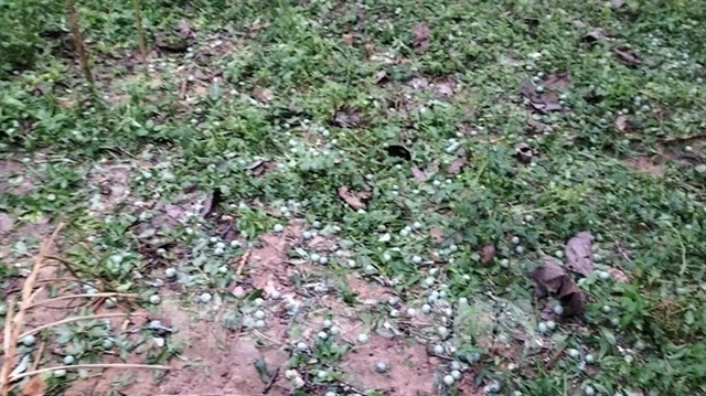
| Hailstorms in Điện Biên damage crops. VNA/VNS Photo |
HÀ NỘI — Hailstorms accompanied by strong thundersqualls struck a number of communes in Điện Biên Province on the afternoon of May 2, causing initial damage to agricultural production and the daily lives of local residents.
In Thanh An Commune, hail fell suddenly, lasting about 10 minutes at high density. Many hailstones were large, some as big as a big toe, blanketing courtyards, gardens, fields and residential areas in white. The intense hail damaged large areas of vegetables, fruit trees and ornamental plants. Rice crops that had reached the ripening stage were flattened and shed their grain, directly affecting yields. Short-season crops such as vegetables, beans and maize suffered heavy losses as there was no time to provide cover.
Strong gusts accompanying the hail also damaged a number of ancillary structures and livestock shed roofing. Reports indicate that the thundersqualls and hail struck over a short period but across a wide area, making on-the-spot response efforts extremely difficult. This is a dangerous weather phenomenon that commonly occurs during the transitional season in the northern mountainous region.
Immediately after the disaster struck, local authorities mobilised forces to go directly to affected areas to record damage, while guiding residents in remedial measures to restore production and daily life as quickly as possible.
The Lào Cai Province Hydrometeorological Station reported that a hailstorm accompanied by strong thundersqualls swept through the communes of Minh Lương, Nậm Xé and Dương Quỳ on the same afternoon, affecting the lives and livelihoods of local people. The hailstorm began at about 4.45pm and lasted 15 minutes, with hailstones of relatively large size.
Although it lasted only a short time, the storm blew the roofs off many homes, punctured fibre-cement roofing and flattened large areas of crops. Local authorities are tallying the damage while directing relevant forces to help residents re-roof their homes and restore normal life as soon as possible.
Residents have been asked to limit outdoor activities during thundersqualls, to inspect and reinforce their structures, and to comply with evacuation guidance at locations at risk of subsidence, so as to ensure the safety of people and property during this peak period of heavy rain and flooding.
At the same time, hail also fell on Văn Bàn area in Lào Cai Province, Đại Từ in Thái Nguyên Province, and a number of areas in the former Hòa Bình Province, now Phú Thọ Province.
In Hà Nội, from about 6pm on May 2, hail was recorded in Long Biên Ward, and former Đông Anh and Thạch Thất districts. Hailstones measured about one to three centimetres. In Hòa Lạc Commune, hail was scattered and accompanied by heavy rain for about 10 minutes.
According to the National Centre for Hydrometeorological Forecasting, the thundersqualls and hail were caused by a surge of cold air pushing down and compressing a low-pressure trough with its axis at about 25-27 degrees north latitude, driving it southward and causing strong atmospheric disturbances.
From midday on May 3, the cold air is forecast to affect the mountainous areas and the north-east region, then spread to the whole of the north-east, the northern central region, parts of the north-west and the central region. Winds will shift to the north-east at force two to three, with coastal areas at force three to four. From the evening and night of May 3, the north-east and the northern central region will turn cooler. Minimum temperatures in the north-east will generally be 20-23 degrees Celsius, with some mountainous areas below 20 degrees Celsius; in the northern central region, 21-24 degrees Celsius.
The National Centre for Hydrometeorological Forecasting said the north will continue to experience thunderstorms on May 3 due to the influence of cold air, with the risk of tornadoes, lightning, hail and strong gusts.
The north-west region will see rain and moderate rain with scattered thunderstorms, and locally heavy to very heavy rain. Minimum temperature: 20-23 degrees Celsius, with some areas below 19 degrees. Maximum temperature: 27-30 degrees, with some areas above 30 degrees.
The north-east region will see rain and moderate rain with scattered thunderstorms, and locally heavy to very heavy rain. Minimum temperature: 20-23 degrees Celsius, with some mountainous areas below 20 degrees. Maximum temperature: 27-30 degrees.
The area from Thanh Hóa Province to Huế City will be sunny, with hot sunshine in the western mountainous areas; showers and scattered thunderstorms are expected in the afternoon and evening, with locally heavy rain. Minimum temperature: 23-26 degrees Celsius. Maximum temperature: 32-34 degrees, with the western mountainous areas from Nghệ An Province to Huế City reaching 35-36 degrees, and some areas above 36 degrees.
The meteorological authority warned that thunderstorms may bring tornadoes, lightning, hail and strong gusts, causing damage to crops, homes and infrastructure. Heavy rain also poses risks of flash floods and landslides in mountainous areas, and waterlogging in low-lying zones.
Trương Bá Kiên, deputy director of the Centre for Meteorological and Climatological Research under the Việt Nam Institute of Meteorology, Hydrology, Environment and Oceanography, said the successive occurrence of hail and thundersqualls during the second half of April was consistent with climatic patterns. There are two main transitional seasons in a year: the transition from spring to summer, and the transition from summer and autumn to winter. These are periods when extreme weather events such as thunderstorms, tornadoes and hail frequently occur.
Kiên said transitional seasons are periods of shift between large-scale circulation systems, marked by the competition between two air masses with entirely different characteristics. In April, for example, the weather shifts from the cold air of winter to the warm air of summer. The interaction between two opposing air masses – one warm and humid, the other dry and cold – readily triggers thunderstorms, tornadoes and hail. The period of September and October is similarly a transitional season from summer and autumn to winter, during which thunderstorms, tornadoes, hail and waterspouts frequently occur.
At sea, from the evening of May 3, the Gulf of Tonkin will have strong north-easterly winds at force five to six, gusting to force seven, with waves of 1.5-2.5 metres. From near dawn on May 4, the north-eastern waters of the northern East Sea will have north-easterly winds at force six, gusting to force seven to eight, with waves of two to three metres and rough seas, affecting vessel operations. — VNS
Society
 Society
 Society
 Society
 Society
 Society
 Society
 Society
 Society
 Society
 Society
 Society
 Society
 Society
 Society