 Society


Việt Nam plans inspection of five jewellery, gemstone businesses
1.

|
| Deputy Prime Minister Trần Hồng Hà chairs a meeting on the emergency response to Typhoon Kalmaegi on Wednesday morning in Hà Nội.— VNA/VNS Photo Việt Đức |
HÀ NỘI — Deputy Prime Minister Trần Hồng Hà told ministries and localities to treat the response to Typhoon Kalmaegi as an operation in “a state of greater emergency and danger”, warning of an unusually intense and fast-moving storm forming late in the year.
Hà, deputy head of the Standing Committee of the National Civil Defence Steering Committee, made the order when he chaired an online meeting with provincial and municipal officials on the emergency response to the storm on Wednesday morning in Hà Nội.
He described the typhoon as “highly abnormal”, noting that it developed rapidly in November, is moving at a speed of 25km per hour, and is forecast to hit with considerable strength.
The deputy PM also stressed that many localities have yet to recover from previous bouts of severe weather, while reservoirs are already near capacity and floodwaters remain high in urban and rural areas. Mountainous regions continue to face worsening risks of landslides, flash floods and erosion.
Hà instructed the Ministry of Agriculture and Environment to strengthen forecasting “to a higher level of precision”, with frequent and detailed updates for each stage of the typhoon’s progression, from its movement at sea and along coastal areas to its landfall and the resulting rainfall, flooding, tornadoes and lightning.
Forecasts, he added, should be compared with previous storms to help localities and residents better visualise expected wind speeds, rainfall volumes and the potential for flooding or landslides.
The typhoon, which is the 13th storm to hit the East Sea (internationally known as the South China Sea) this year, is projected to start affecting Việt Nam from around 7pm on Thursday until about 4am on Friday, leaving “very little time for preparation,” he warned.
Provinces within the affected area are instructed to update plans and response scenarios by Wednesday, and to adjust efforts continuously as new data comes in.
For maritime areas and aquaculture zones, Hà ordered a total ban on all vessels going out to sea and required that no one remains offshore after 5pm on Thursday.
Police and border guards are to ensure safety and protect property for coastal communities.
Evacuations from coastal areas prone to high tides and from mountainous zones at risk of landslides or being cut off from road erosion must be completed before 7pm on Thursday.
Local authorities are to coordinate immediately with Military Region 4 and 5 commands to allocate forces and equipment, “not waiting until isolation occurs before deploying troops,” he said.
Communication networks, including satellite phones at critical points likely to be isolated, must be secured, along with electricity and telecommunications infrastructure.
As for reservoirs, the Deputy PM instructed the environment ministry, the Ministry of Industry and Trade and provincial chairpersons to take immediate responsibility for assessing dam safety and lowering water levels to create flood storage capacity between Thursday and Saturday, when rainfall could exceed 300mm.
Localities were told to quickly assess the need for food, medicine and chemical supplies, with the Ministry of Finance, armed forces and police providing assistance proactively rather than waiting for the storm to strike.
Rescue equipment and vehicles from Military Region 4 and 5 commands, as well as local resources, will also be mobilised in advance to ensure readiness for flooding and transport in inundated areas.
The Ministry of Agriculture and Environment will work with the Ministry of National Defence to designate a command site where the National Civil Defence Steering Committee can operate directly in the typhoon’s core area.

|
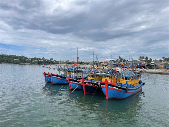
| A soldier from the Nha Trang Port Border Guard uses a loudspeaker to instruct local fishermen on anchoring properly ahead of the typhoon on Wednesday morning in the southern coastal province of Khánh Hòa. — VNA/VNS Photo Đặng Tuấn |
Widespread torrential rains
The National Centre for Hydrometeorological Forecasting said that by late Thursday or early Friday, the storm is expected to make landfall, bringing extremely heavy rain.
From Thursday to Friday, localities from Đà Nẵng to Đắk Lắk Province could see rainfall of 200–400mm, with some locations receiving over 600mm.
Localities from southern Quảng Trị to Huế, Khánh Hòa and Lâm Đồng are forecast to receive 150–300mm, locally over 450mm.
Rain is expected to ease from Saturday.
Between Friday and Saturday, from northern Quảng Trị Province to Thanh Hóa Province, rainfall may reach 50–150mm, with isolated areas exceeding 200mm.
Coastal zones from Huế to Đắk Lắk face risks of storm surge and large waves causing flooding in low-lying areas, with seawater overflow, coastal erosion and delayed drainage expected.
All vessels, fish farms and marine operations in these danger zones will be subject to strong winds, high waves and rough seas.
The centre also warned of potential thunderstorms, squalls and gusts both before and during the storm's landfall.
Speaking at the meeting, Minister of Agriculture and Environment Trần Đức Thắng said the typhoon is “very strong, fast-moving and likely to make landfall with high intensity.”
Thắng added that it poses a major threat to the central region, particularly provinces still reeling from recent floods that left 54 people dead or missing and caused nearly VNĐ3 trillion (roughly US$114 million) in damage from Hà Tĩnh Province to Quảng Ngãi Province.
The typhoon has been classified as posing a Level 4 natural disaster risk, one of the highest in Việt Nam’s warning system, he said.
Local civil defence commands in the localities of Huế, Đà Nẵng, Quảng Ngãi and Đắk Lắk have begun operating multi-reservoir systems along major rivers to manage discharge flows and create flood-buffer capacity downstream.
Reservoirs in the north central region are now 87-100 per cent full, while those in the south central and Central Highlands regions have reached 66-99 per cent of designed capacity.
Coastal erosion is being reported or anticipated in several areas, including Cửa Đại, Hội An and An Mỹ, prompting calls for reinforcement of vulnerable points ahead of the typhoon's landfall.
The Border Guard Command accounted for 59,379 vessels with nearly 318,000 crew members, directing them to move out of danger zones.
Thắng said that in response to forecasts, the Prime Minister and the National Civil Defence Steering Committee have already issued urgent directives, urging all ministries and localities to act “early and from afar” to safeguard lives and reduce damage.
Deputy Minister Nguyễn Hoàng Hiệp said the storm is expected to hit land around Quy Nhơn area and southern Quảng Ngãi Province, with wind gusts reaching levels 13–14 on the Beaufort scale, strong enough to tear off roofs and collapse houses.
The coastal terrain of Quy Nhơn is open and directly exposed to the wind, making the area particularly dangerous, he said.
He added that widespread rainfall from the storm’s circulation could trigger landslides and isolation in localities of Gia Lai, Đắk Lắk, Quảng Ngãi and Quảng Nam.
A sharp flood peak may occur in the early hours of Saturday, rising and receding rapidly, with significant danger.
Many hydroelectric and irrigation reservoirs in these basins are already full, requiring early, controlled discharge to prevent “flood upon flood” scenarios.
Coastal areas with large numbers of floating fish cages are also at high risk, particularly if people stay behind to guard their farms.
Solar farms across the region are advised to strengthen structures and brace for impact.— VNS
Society
 Society
 Society
 Society
 Society
 Society
 Society
 Society
 Society
 Society
 Society
 Society
 Society
 Society
 Society