 Society


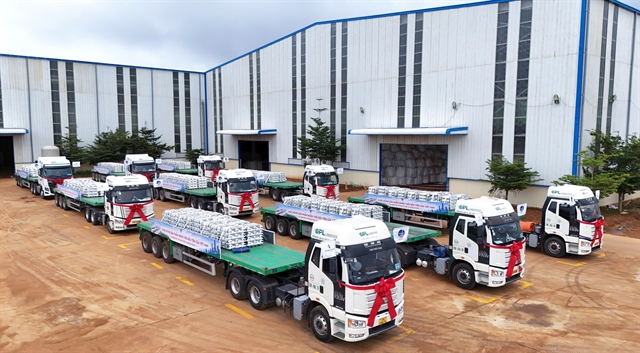
Việt Nam advances deep processing with first aluminium ingot production
1.
|
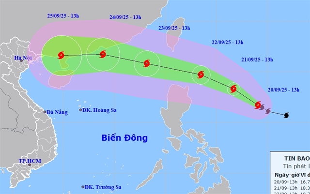
| One possible path of Typhoon Ragasa. — Image courtesy of the National Centre for Hydrometeorological Forecasting. |
HÀ NỘI — Typhoon Ragasa is expected to strengthen into a super typhoon with wind speeds of more than 200km per hour when the storm system enters the East Sea (internationally known as the South China Sea) on Tuesday.
Its movement is complicated, and the National Centre for Hydrometeorological Forecasting (NCHMF) predicts two scenarios: either the storm will hit China and weaken before affecting Việt Nam, or it will veer westward and make direct landfall here.
Nguyễn Văn Hưởng, head of the Weather Forecasting Division under the NCHMF, said that Ragasa is set to be the first super typhoon in the Northwest Pacific region this year.
The path of the typhoon is still relatively complex to predict, and international forecasts vary considerably.
Some experts expect that as Ragasa approaches the 120th meridian, it will turn northward toward Taiwan (China). Under this scenario, the system would have minimal impact on Việt Nam.
However, the highest probability is that Typhoon Ragasa will enter the East Sea (internationally known as the South China Sea) on Tuesday, becoming storm number nine, with two possible pathways.
The first potential scenario is that the typhoon hits land in China's Guangdong Province, passes the Leizhou Peninsula (also in China), and then affects mainland Việt Nam with a significantly weakened intensity.
The second, and worst-case scenario, is that once in the East Sea, the typhoon primarily moves westward, making landfall in northern and central Vietnam. Although its intensity may weaken after passing Hainan Island in China, it would still have a strong impact.
“In addition, we are observing an early-season cold air mass moving south toward Việt Nam. The interaction between this cold air and Typhoon Ragasa may cause its path and impact to become more complicated," said Hưởng.
He also noted that forecasts of the typhoon’s impact remain uncertain at this time. People should therefore pay close attention to upcoming typhoon forecasts.
Hưởng said that regardless of which scenario the typhoon follows, from Thursday to Saturday, the northern and central regions of Việt Nam (from Thanh Hoá Province to Huế City) are highly likely to experience heavy rain and strong winds.
Super typhoon
The NCHMF said that by 1am on Tuesday, the typhoon’s centre will likely be over the northern waters of Luzon Island in the Philippines. The natural disaster risk level is level four.
On Wednesday, the typhoon is expected to maintain its direction while accelerating to 20–25km per hour. By 1am on Wednesday, its centre will be about 140km southeast of Hong Kong (China).
Winds are likely to remain at super typhoon strength of more than 200km per hour.
Afterwards, experts believe the typhoon is likely to move westward before turning west-southwest, travelling at about 20km per hour, with gradually weakening intensity.
The NCHMF is closely monitoring Typhoon Ragasa’s development. Authorities and residents are advised to keep updated on typhoon forecasts, especially short-term warnings, to respond in a timely manner and ensure the safety of lives and property.
According to the meteorological agency, the typhoon may have the potential to sink large vessels, cause dike breaches and uproot trees.
Due to the influence of Typhoon Ragasa, waves from four to eight metres high may be seen, with some more than 10 metres near the typhoon's centre. — VNS
Society
 Society
 Society
 Society
 Society
 Society
 Society
 Society
 Society
 Society
.JPG) Society
Society
 Society
 Society
 Society
 Society
.jpg)