 Society

No additional Vietnamese casualties reported in Japan quake: Consulate General
1.
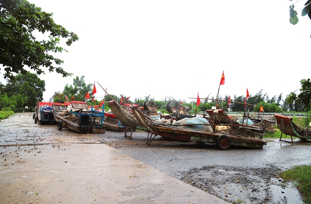 |
| Fishermen in Nghệ An Province's Hải Châu Commune haul over 400 fishing boats to safe areas. — VNA/VNS Photos |
HÀ NỘI — Typhoon Kajiki, the fifth storm set to strike Việt Nam so far this year, was located around 140km east-southeast of Nghệ An Province and 120km east of Hà Tĩnh Province at 9am on Monday, with sustained winds of 134-166km/h (level 13-14) and gusts reaching level 16.
According to the National Centre for Hydrometeorological Forecasting, the storm is expected to make landfall later Monday and has already forced the evacuation of thousands of people in high-risk areas from Ninh Bình to Huế.
Local authorities in the north-central province of Thanh Hóa alone have relocated 1,800 households from Nghi Sơn, Quảng Xương and Sầm Sơn, with further evacuations underway in Hoằng Hóa.
Hà Tĩnh Province has moved more than 14,000 residents, mainly in low-lying coastal communes like Thiên Cầm and Kỳ Anh.
Deputy Prime Minister Trần Hồng Hà, chairing an emergency meeting from the Government’s forward command office at Military Region 4 (based in Nghệ An Province), warned central provinces from Quảng Trị to Thanh Hóa to complete evacuations before 11am on Monday and ordered residents not to leave their homes between 11am and 6pm.
He said that the storm could be as strong as super typhoon Yagi, which devastated northern provinces in 2024. Level-four houses (those with tile, tin or asbestos roofs) could collapse, and even high-rise buildings may suffer serious damage. Hà urged localities to reinforce homes and strengthen communication with residents.
Highlighting the critical role of communications in command and coordination, Hà instructed Viettel and VNPT to immediately check equipment for local leaders and disaster response officials. He assigned the Ministry of Agriculture and Environment and the Ministry of Industry and Trade to take overall responsibility for regulating reservoirs and dams. Local authorities were asked to conduct early inspections, make prompt proposals, and strictly prevent incidents caused by negligence.
 |
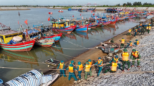
| Border guards in Quảng Trị Province help residents reinforce their homes and secure belongings ahead of Typhoon Kajiki. |
Flood risks
Heavy rain is forecast to follow Kajiki’s landfall, with accumulations of up to 600mm in some areas. Authorities have raised concerns about severe flooding in low-lying urban centres, along with flash floods and landslides in mountainous districts.
In Hà Tĩnh Province, six reservoirs, including Sông Rác and Bộc Nguyên, have begun emergency water discharges to ease pressure on dams. Meanwhile, Thanh Hóa has established a forward command post in Quan Hóa District to coordinate disaster response in the province's mountainous western area, where landslides and road blockages are expected.
The Ministry of Agriculture and Environment reported 43 weak points in coastal dikes from Ninh Bình to Huế. Most sea dikes are designed to withstand storms of only level 9-10, raising fears they could be overtopped by Kajiki’s winds and storm surges.
Particularly vulnerable sections include Hải Bình in Thanh Hóa, which was breached in 2017, and dikes at Hội Thống, Lộc Hà and Cẩm Nhượng in Hà Tĩnh.
By Monday morning, winds of level 5-6 and heavy rain had already been reported in southern and western Thanh Hóa, while stronger gusts swept the Hà Tĩnh coast. In Kỳ Anh, residents rushed to secure their homes with sandbags, ropes and makeshift reinforcements, while shops closed and streets emptied. Construction crews dismantled scaffolding and secured equipment ahead of the storm.
Meteorologists explained that Kajiki has maintained its intensity close to shore due to warm sea surface temperatures of up to 30 degrees Celsius, favourable atmospheric conditions and additional energy from the southwest monsoon.
 |
| Deputy Prime Minister Trần Hồng Hà and his working delegation inspect reinforcement work on the Hội Thống dike in Đan Hải Commune, Hà Tĩnh Province. |
Việt Nam’s meteorological agency said that international forecasters hold a similar view of the storm’s expected intensity at landfall, estimating it at level 13-14 in Japan and China, and level 14 in Hong Kong (China).
Authorities have suspended the opening of schools in Thanh Hóa today and tomorrow, while work crews and hundreds of heavy machines have been mobilised to secure dikes, reinforce transport links and stand ready for search and rescue.
The storm is forecast to strike between midday and late afternoon on Monday, with winds of level 12-14 and gusting to level 16, in southern Thanh Hóa, Nghệ An and northern Hà Tĩnh provinces. Surrounding provinces may experience winds of level 8-11, with dangerous gusts extending far inland. — VNS
Society
 Society
 Society
 Society
 Society
 Society
 Society
 Society
 Society
 Society
 Society
 Society
 Society
 Society
 Society