 Society

 |
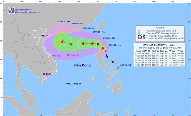
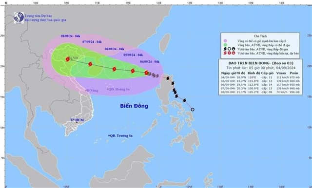
| The movement of Storm Yagi at 4am on Wednesday. The storm moves in a west-northwest direction at about 10 kph. VNA/VNS Photo |
HÀ NỘI — The National Centre for Hydrometeorological Forecasting has outlined two potential scenarios for the trajectory of Storm Yagi, the third tropical storm this year.
Both scenarios predict heavy rainfall, posing a significant risk of flash floods, landslides—especially in mountainous regions—and urban flooding.
On Tuesday evening, Vũ Anh Tuấn, Deputy Head of the Weather Forecasting Department, reported that after entering the East Sea (known internationally as the South China Sea), the storm is gradually moving westward at a slow pace while intensifying.
As of Tuesday evening, the storm’s centre has reached a wind speed of level 10 (75-102 km/h), an increase of two levels compared to the forecast issued on Sunday morning.
As the storm advances further into the East Sea, it is expected to continue strengthening, possibly reaching level 14 in the northern part of the East Sea by Friday afternoon (6 September). The natural disaster risk level has been raised to level 4.
Regarding the characteristics of Storm Yagi, Tuấn noted that in addition to its intensification upon entering the East Sea, the storm's wind radius is also expanding, which will amplify as the storm strengthens.
Moreover, strong thunderstorms may develop ahead of the storm’s influence, potentially causing tornadoes and strong winds at sea.
Tuấn mentioned that the storm is expected to maintain a steady westward direction at a speed of about 10-15 km/h until Friday morning (6 September). After that, two scenarios could unfold, both directly impacting Việt Nam’s mainland.
In the first scenario, Yagi may move northward, passing over Hainan Island (China) and entering the northern part of the Gulf of Tonkin around 6-7 September. This scenario could bring heavy rainfall to northern Việt Nam.
In the second scenario, by Friday afternoon, the storm could shift southwest, loop south of Hainan Island, and enter the southern part of the Gulf of Tonkin. This outcome could result in heavy rainfall in both northern and north-central Việt Nam.
In either scenario, substantial rainfall is anticipated, significantly increasing the risk of flash floods, landslides—particularly in mountainous areas—and urban flooding.
Additionally, as the storm moves inland, its wide circulation may generate strong winds along the coast of northern and north-central cities and provinces.
Tuấn stressed that Storm Yagi is very powerful, and besides the expected strong winds, it could generate waves as high as 7-9 metres in the eastern part of the northern East Sea between Wednesday night (4 September) and Friday (6 September). This poses a serious danger to vessels operating in the area, with even large ships at risk of capsizing due to the waves. — VNS


