 Society


MoST shifts focus from policymaking to implementation to drive growth
1.
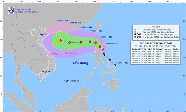 |
| The direction of the typhoon Yagi. — VNA/VNS Photo |
HÀ NỘI —As of 7 a.m. on September 3, the eye of Tropical Storm Yagi was located over the northeastern waters of the North East Sea, according to the National Centre for Hydro-Meteorological Forecasting.
Winds near the storm’s centre were measured at level 8 (62-74 km per hour), with gusts reaching up to level 11.
The storm is forecast to enter the East Sea by the afternoon or evening of September 3, making it the third storm of the year.
Over the next 24 hours, Yagi is expected to move west-northwest at approximately 10 km per hour, entering the East Sea and intensifying further.
By 7 a.m. on September 4, the storm's centre is projected to be about 740 km east of Hainan Island, China, with winds strengthening to levels 9-10 and gusts at level 12.
In the subsequent 24 to 48 hours, the storm is expected to shift westward at about 10 km per hour, continuing its trajectory into the East Sea and potentially gaining more strength.
By 7 a.m. on September 5, Yagi is forecasted to be approximately 400 km east of Hainan Island, with winds reaching levels 11-12 and gusts at level 14.
The storm is expected to maintain a westward course over the next 48 to 72 hours, with further intensification likely.
By 7 a.m. on September 6, Yagi’s centre is anticipated to be over the eastern waters of Hainan Island, with winds reaching level 13 and gusts up to level 16.
Over the following 72 to 120 hours, Yagi is expected to continue moving west-northwest at 10-15 km per hour, with the potential for further strengthening.
Starting from September 3, the northeastern waters of the North East Sea will experience increasingly strong air currents, reaching level 6, with winds near the storm's centre at levels 8-9 and gusts above levels 11-12, leading to rough seas.
The meteorological agency has issued a warning that from September 4-6, Typhoon Yagi could reach very strong levels in the northeastern part of the East Sea, with maximum winds potentially reaching levels 12-13 and gusts at level 16 near the storm's centre.
For the next 24 hours, the eastern waters of the North East Sea will see waves near the storm's centre reaching 3-5 metres, possibly increasing to 5-7 metres later. The sea will be extremely rough and highly dangerous for vessels.
Nguyễn Văn Hưởng, head of the weather forecasting division at the National Centre for Hydro-Meteorological Forecasting, noted that as Typhoon Yagi enters the East Sea, conditions such as wind, air pressure, and sea surface temperatures of 30-31°C will likely contribute to further intensification.
As of the afternoon of September 2, both Vietnamese and international forecasting centres agree that once it enters the East Sea, Typhoon Yagi will predominantly move westward and intensify.
All forecasts suggest that Typhoon Yagi will reach its peak intensity in the eastern area of Hainan Island, China, although there are significant differences in predictions.
Japan forecasts a peak intensity at level 13, with gusts at level 17, while China and Hong Kong forecast a maximum intensity at level 15. The US predicts level 16 (a super typhoon), with gusts exceeding level 17. — VNS
Society
 Society
 Society
 Society
 Society
 Society
 Society
 Society
 Society
 Society
 Society
 Society
 Society
 Society
 Society