 Society

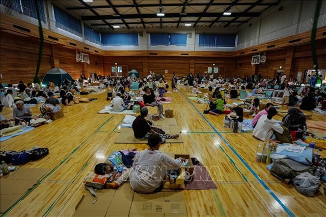
Vietnamese community in Japan gradually returns to normal after earthquake disaster
1.
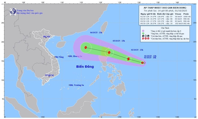 |
| Forecast map of the tropical depression’s track and intensity issued at 2pm on Wednesday. Photo of the National Centre for Hydro-Meteorological Forecasting |
HÀ NỘI — While Việt Nam is still reeling from the catastrophic Typhoon Bualoi (Storm No.10), a tropical depression over the Philippine Sea is moving toward the East Sea (South China Sea) and may strengthen into a storm in the coming days.
According to the National Centre for Hydro-Meteorological Forecasting, as of 1 pm Wednesday, the depression’s centre was located near 14.5 degrees north latitude and 130.9 degrees east longitude, east of Luzon Island (Philippines). Maximum sustained winds near the centre reached 50–61 kph and was moving west at about 15kph.
By 1 pm on October 2, the system is forecast to move west-northwest at 15–20 kph and is likely to intensify into a tropical storm. At that time, its centre would be around 15.5 degrees north latitude and 127.3 degrees east longitude, still east of Luzon. Maximum winds are expected to strengthen to 62-74kph, with gusts at 89-102kph.
By 1 pm on October 3, the storm is projected to continue moving west-northwest at 15–20 kph, with further strengthening. Its centr eis expected to be located east of Luzon with maximum winds at 75-88kph, gusting to 89-102kph. The disaster risk level is placed at Level 3 for the northeastern waters of the East Sea.
Over the following 48 to 72 hours, the storm is expected to track mainly west-northwest at 25–30 kph, entering the East Sea and continuing to intensify.
At sea, from October 3, the northeastern waters of the East Sea will experience strengthening winds of 50-61kph, while areas near the storm center may see winds of 62-74kph with waves 2.5–4.5 metres high and rough seas.
Between October 4–6, the northern part of the East Sea, including the Hoang Sa (Paracel) archipelago, may be affected by strong winds of 89-117kph. Vessels operating in the hazardous zones are warned of possible thunderstorms, waterspouts, strong winds, and high seas. — VNS
Society
 Society
 Society
 Society
 Society
 Society
 Society
 Society
 Society
 Society
 Society
 Society
 Society
 Society
 Society