 Society


Malaysia police bust two scam centres in Johor’s Forest City, at least 194 foreigners to be charged
1.
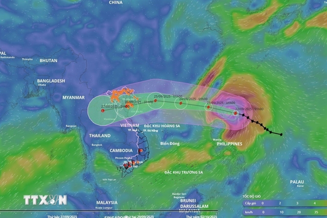 |
| An aerial image shows the direction of Ragasa storm. Photo courtesy of the National Centre for Hydro-meteorological Forecasting |
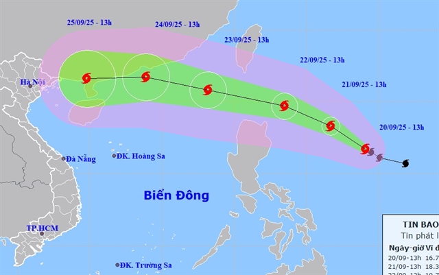
HÀ NỘI – Super typhoon Ragasa is forecast to enter the East Sea around 7am on Tuesday (September 23), bringing extremely strong winds at level 17, with gusts exceeding level 17, according to the National Centre for Hydro-meteorological Forecasting (NCHMF).
The disaster risk has been assessed at level 4.
As of 7am on Monday (September 22), the storm's centre was located at approximately 19.3 degrees North latitude; 123.1 degrees East longitude, about 160km northeast of Luzon Island of the Philippines.
The maximum wind near the storm’s centre reached level 17, ranging from 202 to 221 km/h, with gusts surpassing that threshold. The storm was moving in a west-northwest direction at a speed of about 20kmph.
By Tuesday morning, Ragasa is forecast to be positioned over the northeastern sea area of the northern East Sea (internationally known as the South China Sea), continuing its west-northwest trajectory at approximately 20 km/h. The storm will bring violent winds at level 17 and higher gusts to the eastern waters of the northern East Sea.
As of 7am on Wednesday, the storm is located in the northern sea, specifically in the North-Northeast region, approximately 490km east of Leizhou Island (China). It is packing strong winds at levels 16–17, with gusts exceeding level 17. The storm is moving in a west-northwest direction at a speed of around 20 km/h and is entering the East Sea. The affected area includes the northern sea region of the North East Sea.
By 7am on Thursday, the storm is expected to move over the eastern waters of the Gulf of Tonkin, with sustained winds reaching levels 13–14 and gusts exceeding level 17. It was tracking westward at a speed of 15–20 km/h and gradually weakening. The affected regions included the northwestern waters of the northern East Sea and the Gulf of Tonkin.
Over the following 72 to 120 hours, the storm is forecast to continue moving west-southwest at approximately 20 km/h, with its intensity steadily decreasing.
Asso. Prof. Dr. Mai Văn Khiêm, NCHMF’s director, said that due to the storm’s influence, the eastern sea of the northern East Sea would see gradually increasing winds, reaching levels 8-9, then strengthening to levels 10-14, with areas near the super typhoon’s centre reaching levels 15-17, gusting above level 17. Waves could exceed 10m, causing extremely rough seas.
Ships operating in the hazardous areas mentioned above could face thunderstorms, tornadoes, strong winds, and high waves.
Flash floods and landslides warnings
There is high risk of heavy rain, flash floods and landslides in the northern mountainous provinces of Lai Châu, Điện Biên, Sơn La, Lào Cai and Tuyên Quang.
NCHMF has forecast that from 4:40am to 9:40am on Monday, the provinces continued to experience rainfall with accumulated amounts commonly between 10-40mm, and in some places over 80mm.
There is a warning of possible flash floods on rivers and small streams, and landslides on steep slopes in many communes and wards.
Flash floods and landslides could cause very serious impacts on the environment, threaten human lives, cause local traffic disruptions, hinder vehicle movement, destroy public and economic infrastructure, and inflict damage on production as well as socio-economic activities.
The centre has recommended that local authorities review areas with stream blockages and vulnerable sites to take measures for prevention and response.
From midnight to 3am on Monday, these provinces had moderate to heavy rainfall, such as Nậm Xe 1 (Lai Châu) with 47.8mm; Mường Pồn 2 (Điện Biên) - 99mm; Pha Khinh (Sơn La) - 63.2mm; Tân Tiến (Lào Cai) - 70mm; and Tùng Bá 1 (Tuyên Quang) - 93.4mm.
Soil moisture models indicate that some areas in these provinces are nearly saturated (above 85 per cent) or already saturated.
NCHMF reported that at 1am on Monday, the central area of the East Sea, the northern part of the Gulf of Tonkin, and the sea area from Gia Lai to Cà Mau experienced scattered showers and thunderstorms. The waves is over 2m high. VNS
Society
 Society
 Society
 Society
 Society
 Society
 Society
 Society
 Society
 Society
 Society
.jpg) Society
Society
 Society
 Society
 Society