LÀO CAI — Prolonged heavy rainfall caused by Typhoon Yagi has triggered widespread and severe flooding in the northern region, causing significant loss of life and property damage.
On Monday morning, Lào Cai Province declared a state of emergency due to the disaster.
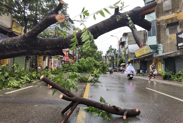
Heavy rainfall has caused landslides, resulting in the deaths of six people and injuries to nine others in Hòa Sử Pán 1 Village, Mường Hoa Commune in Sa Pa Town. Fifty homes have been affected and over 248 hectares of agricultural land have been submerged in Văn Bàn, Bảo Thắng and Bảo Yên districts. Many sections of national, provincial and district roads have also experienced landslides.
Initial damage estimates for the area are over VNĐ7 billion (US$283,880).
Heavy rain combined with floodwaters from upstream has caused water levels of the Red River to reach a peak of up to 84.5 metres as of 1pm on Monday.
Rainfall exceeding 100mm is ongoing throughout the region. There is a high risk of flooding in low-lying areas and landslides on steep slopes, as well as along the downstream banks of the Red River in Lào Cai City as well as in Bảo Thắng, Bảo Yên and Văn Bàn Districts.
 |
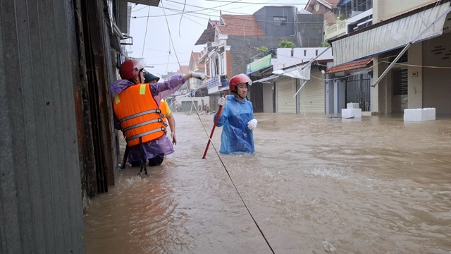
| Residents of Lào Cai City move their belongings to a safe location. |
Chairman of the Lào Cai Provincial People’s Committee Trịnh Xuân Trường has instructed local authorities to urgently relocate families living in areas at risk of landslides and flash floods to safer locations.
In Sa Pa Town, Trường has called for an urgent mobilisation of forces to search for missing people, respond to the disaster and assist residents in overcoming the damage, while ensuring security in affected areas.
Evacuated individuals and families are being provided with temporary shelter.
 |
| Soldiers assist residents in transporting their belongings to safety. |
In Hà Giang Province, a three-year-old child from Hấu Chua Village, Giàng Chu Phìn Commune, Mèo Vạc District, was swept away by floodwaters while crossing a stream on the way to class.
Lê Anh Dũng, deputy Chief of Office of the Provincial Steering Committee for Disaster Prevention and Search and Rescue, stated that authorities have recovered the child's body and handed it over to the family, while planning further support measures.
Heavy rain and flooding have submerged nearly 140 houses and damaged around 500 hectares of crops. In Bắc Quang District alone, nearly 5,000 poultry and around 100 livestock in Bắc Quang and Đồng Văn Districts were swept away by floodwaters.
Meanwhile in Quảng Ninh Province, floodwaters rose in Đông Hải Commune, causing the Hà Thanh dike to breach on Monday morning and flooding around 400 households in the villages of Hà Tràng Đồng, Hà Tràng Tây and parts of Nà Bấc and Khe Cạn, with water levels reaching up to 1.5 metres inside homes.
The flood also submerged approximately 100 hectares of crops. Additionally, a 30-metre section of the Hà Tràng Tây dike collapsed, causing one household to lose all its possessions.
The total property damage is estimated at over VNĐ550 billion.
 |
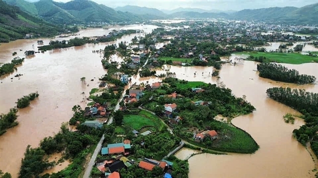
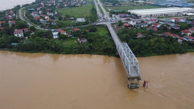
| Nà Vuồng Village in Yên Phong Commune, Bắc Mê District, Hà Giang Province is submerged, and National Route 34 between Bảo Lâm and Cao Bằng is cut off. |
Due to the rising floodwaters of the Red River, at least 3,500 households in Yên Bái City in Yên Bái Province were forced to evacuate on Monday afternoon.
Some roads in Hồng Hà Ward and Tuy Lộc Commune were submerged up to 4 metres deep.
 |
| Hồng Hà, Thái Học and Yên Ninh Wards in Yên Bái City were heavily flooded on Monday morning. |
Initial reports from the Yên Bái Provincial Steering Committee for Disaster Prevention and Search and Rescue showed that by noon on Monday, landslides had killed three people in Yên Bái Province and injured four others in Liễu Đô and Động Quan Communes in Lục Yên District.
Flooding also caused the collapse of or damage to more than 5,687 houses in the districts of Mù Cang Chải, Yên Bình, Trạm Tấu, Văn Yên, Trấn Yên, Lục Yên and Nghĩa Lộ Town, as well as Yên Bái City.
A total of 1,914.71 hectares of crops were damaged or affected.
In terms of transportation, many main roads leading to the districts across the province were cut off due to flooding, landslides, and fallen trees. National Highway 32 experienced 64 landslide points.
Nguyễn Ngọc Trúc, Chairman of the Yên Bái City People’s Committee, said that nearly 1,000 people, including soldiers, police officers and militiamen, have been mobilised, along with over 10 vehicles, boats and other equipment, ready to respond to any emergencies.
During the night of Sunday, several areas in Thái Nguyên Province were heavily flooded, forcing authorities to evacuate hundreds of households overnight.
 |
| Thái Nguyên High School for Gifted Students in Túc Duyên Ward, Thái Nguyên City, is heavily flooded. VNA/VNS Photo Hoàng Nguyên |
High water levels on the Cầu River at the Gia Bẩy hydrological station and floodwater discharging from Núi Cốc Reservoir on the Công River at a rate of 150 cubic metres per second have caused severe flooding in the Thái Nguyên City neighbourhoods of Đồng Bẩm, Quang Vinh and Túc Duyên.
Many main roads are submerged, disrupting daily life. Authorities have worked around the clock, placing warning signs to block all traffic and pedestrian access to deeply flooded areas and key bridges such as Gia Bẩy and Bến Tượng.
At around 10pm on Sunday night, the People’s Committee of Hoàng Văn Thụ ward mobilised forces to evacuate around 50 households totalling 200 people from the A3 building of Tiến Bộ Apartment Complex.
 |
| Residents of Đồng Bẩm Commune, Thái Nguyên City, have had to travel by boat. VNA/VNS Photo Thu Hằng |
To ensure residents' safety, the apartment’s management board cut off electricity in the entire building, while city and ward authorities assisted in the evacuation.
In Phú Thọ, rising river levels threatened to breach the left embankment of Ngòi Vần in Hiền Lương Commune, Hạ Hòa District.
On Sunday night, the Hạ Hòa District People’s Committee ordered the evacuation of 205 households with 770 people to higher ground.
According to the National Centre for Hydrometeorological Forecasting, on Monday morning water levels were rising on the Thao River, the Lô River, the Lục Nam and Thương Rivers and the Thái Bình River.
In Hà Nội, water levels on the lower Red River are expected to rise quickly due to the release of floodwater from the Hòa Bình hydropower plant's second bottom gate and Tuyên Quang hydropower plant's three bottom gates, but will likely remain below the first level alert.
There is a high risk of flooding in low-lying areas along rivers as well as risks of flash floods and landslides on steep slopes in Lạng Sơn, Cao Bằng, Lào Cai, Yên Bái, Phú Thọ, Bắc Giang, Bắc Kạn, Thái Nguyên, Hòa Bình, Ninh Bình and Thanh Hóa provinces. The disaster risk level due to floods is at level 3. — VNS
 Economy