 Environment

HCM City prioritises logistics infrastructure to raise direct import-export throughput above 80%
1.
|
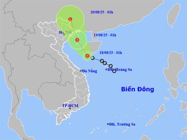
| The forecast track of the tropical depression in the coming days. — Photo nchmf.gov.vn |
HÀ NỘI — A tropical depression is forecast to move into the northern part of the Gulf of Tonkin this evening, bringing heavy rain, strong winds and rough seas to several coastal and inland areas.
According to the National Centre for Hydro-Meteorological Forecasting, the system was located south of Hainan Island (China) early on Monday with maximum sustained winds of 39–49km/h (level 6 on the Beaufort scale), gusting up to 61km/h (level 8).
It is moving northwest at about 15km/h.
By around 1am on August 19, the depression is expected to maintain its intensity at level 6, gusting to level 8, and remain active in the northern Gulf of Tonkin.
The eastern waters from Quảng Trị to Huế and the Gulf of Tonkin, including Bạch Long Vĩ and Cô Tô islands, are likely to be affected.
The system is forecast to weaken into a low-pressure zone by 1am on August 20 over southern Guangxi Province, China.
Under its influence, the eastern waters from Quảng Trị to Huế and the Gulf of Tonkin will see thunderstorms, strong winds of level 6, gusting to level 8, and waves up to 3m high, causing rough seas.
Authorities warned that vessels operating in the hazardous area face risks of squalls, strong winds and large waves.
From last night through early this morning, coastal and delta areas in the north, as well as provinces and cities from Thanh Hóa to Quảng Trị, experienced rain and thunderstorms, with some places seeing heavy downpours.
Forecasts indicate that from now until the night of August 19, the northeastern region and Thanh Hóa will face moderate to heavy rain, with widespread totals of 50–130mm and some locations exceeding 250 mm.
In the central province of Nghệ An, rainfall on Monday is expected to reach 30–60mm, with some areas receiving more than 120mm. Hà Tĩnh and Quảng Trị may see 20–50mm, with isolated spots exceeding 80mm.
Elsewhere, the northwestern region, localities from Huế to Lâm Đồng and the southern region are forecast to have scattered showers and thunderstorms of 15–30mm, with some areas exceeding 80mm. Rainfall will be concentrated in the afternoon and evening. — VNS
Environment
 Environment
 Environment
 Environment
 Environment
 Environment
 Environment
 Environment
 Environment
 Environment
 Environment
 Environment
 Environment
 Environment
 Environment