 Society

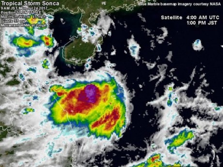
Tropical Storm Sonca, the fourth to hit Việt Nam this year, is forecast to make landfall in central and northcentral Việt Nam on Tuesday night and early Wednesday morning, according to the National Hydro-meteorological Forecast Centre.
 |
| The latest image of Storm Sonca (or Storm No 4). — Source: The National Hydro-meteorological Forecast Centre |
HÀ NỘI — Tropical Storm Sonca, the fourth to hit Việt Nam this year, is forecast to make landfall in central and northcentral Việt Nam on Tuesday night and early Wednesday morning, according to the National Hydro-meteorological Forecast Centre.
According to the centre, the storm has hardly moved in the past 24 hours. At 4am on Monday, the typhoon location was about 150km southeast of Hainan (China).
The strongest winds near the typhoon centre reach the speed of 60km-75km per hour.
In the next 24 to 48 hours, the storm is forecast to make landfall from Thanh Hóa to Quảng Bình provinces before weakening into a tropical depression.
From tomorrow, coastal areas from Thanh Hóa to Quảng Binh will have high waves of up to 2-3m and rough sea. These provinces will also face torrential rainfall of 100-250mm.
From Tuesday evening and night, in the Red River delta, Hòa Bình, Sơn La and the north of Central Highlands, there will be moderate to heavy rain (rainfall from 50 to 150mm).
By 4am on Wednesday, the Tonkin Gulf is precdicted to experience strong wind of 40-60km per hour.
Sonca Storm will also bring rains and thunderstorms in the middle and south of East Sea (including the Spratly Islands), and the sea areas from Ninh Thuận to Cà Mau province.
From Cà Mau to Kien Giang province, the Gulf of Thailand, there will be rain showers and scattered thunderstorms. During thunderstorms, tornadoes and gusts can occur. — VNS