Society


33rd Diplomatic Conference: Vietnamese diplomacy shifts from paving the way to creating development resources
1.
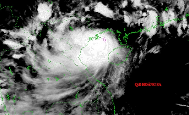 |
| A radar image of the incoming typhoon Wipha. — Photo from the National Centre for Hydro-Meteorological Forecasting |
HÀ NỘI — Typhoon Wipha, the third storm of the season to enter the East Sea (South China Sea) this year, has unexpectedly slowed its movement and is intensifying, raising concerns about stronger winds, heavier rains, and a longer period of dangerous weather across northern Việt Nam.
As of 10pm on Monday, the National Centre for Hydro-Meteorological Forecasting reported that the typhoon was located approximately 80km southeast of Quảng Ninh, 180km east of Hải Phòng, 190km from Hưng Yên, and 220km east-northeast of Ninh Bình. The storm’s maximum sustained winds near its centre reached level 10 (89–102km/h), with gusts up to level 13 (134–149km/h)
Forecasters predict that by Tuesday morning, the typhoon will be positioned over the waters off the coast of Quảng Ninh to Ninh Bình and could further strengthen to level 10–11 (up to 117km/h), with gusts of up to level 14 (150–166km/h).
According to meteorologist Mai Văn Khiêm, Director of the National Centre for Hydro-Meteorological Forecasting, Wipha has shown minimal movement since the late afternoon today, based on satellite tracking from 5pm to 7pm.
"When a typhoon stalls or slows down, it tends to grow stronger and exerts a longer-lasting influence, making it more dangerous than fast-moving storms," Khiêm warned at a briefing on Monday evening.
While the typhoon’s path has not yet shown abnormal deviations, the stalling could signal a shift in direction. Forecast models still indicate the storm will move towards coastal areas from Hải Phòng to northern Thanh Hóa.
Forecasts show that by Tuesday midday, the typhoon will make landfall in areas from Hải Phòng to northern Thanh Hóa.
Khiêm noted that the period of most dangerous winds for the Red River Delta and Thanh Hóa would be between 10am and 3pm on Tuesday.
From tonight through Tuesday morning, heavy rainfall is expected across the Northeast, Red River Delta, Thanh Hóa, and Nghệ An regions. In Quảng Ninh, the rain is forecast to continue until late Tuesday. Meanwhile, rain in Thanh Hóa and Nghệ An will persist until the morning of Wednesday, though it may weaken thereafter.
The Meteorological Centre warned of a high risk of flash floods and landslides, particularly in mountainous areas.
The meteorological agency has warned that in areas with many high-rise buildings in urban areas like Hà Nội, wind tunnel effects can significantly increase wind speeds as gusts are funnelled through these zones, which would potentially make the winds much stronger in reality than those recorded at monitoring stations. Residents are advised to stay indoors during periods of strong wind to ensure their safety.
Total rainfall in Hà Nội is forecast to range between 100mm and 200mm, with some areas possibly exceeding 300mm. Heavy downpours in a short period, combined with localised thunderstorms, pose a risk of flooding in low-lying areas. — VNS
Society
 Society
 Society
 Society
 Society
 Society
 Society
 Society
 Society
 Society
 Society
 Society
 Society
 Society
 Society