 Society

Hà Nội's path to green growth
1.
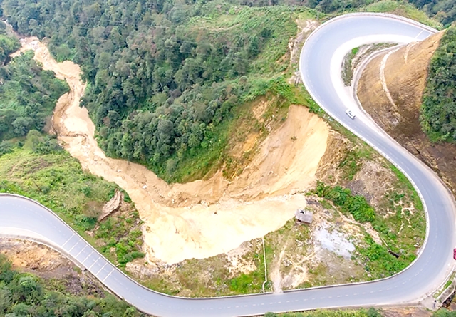 |
| A landslide affected area near the Ô Quy Hồ Pass in the northern Lai Châu Province. — Photo vietnamplus.vn |
Việt Nam to complete maps of landslide risk zones by 2025
HÀ NỘI — Maps indicating landslide-prone areas in 37 mountainous and midland areas will be completed by 2025 under an early-warning project managed by the Ministry of Environment and Natural Resources, Hoàng Đức Cường, deputy head of the ministry’s Meteorological and Hydrological Administration, has said.
The maps would be on a scale of 1:50,000 in 37 provinces and 1:10,000 and larger in 150 high-risk areas.
The project also targets completing by 2030 an early warning system for landslides and floods that can be shared among ministries and localities, he said.
Early warning is not enough for minimising the impacts and risks caused by natural disasters, and early action is needed including regular checks of risk-prone areas, he said.
Local authorities need to move out people living in those areas, he told the Vietnam News Agency.
According to the Meteorological and Hydrological Administration, Việt Nam is one of the countries severely affected by natural disasters and climate change.
Natural disasters routinely occur in all parts of the country, and are becoming more frequent and severe, he said.
It is estimated that in the 10 years to 2022 over 220 people died or went missing every year due to natural disasters, which also caused losses of VNĐ23 trillion, according to the administration.
Flash floods and landslides, which occur frequently in mountainous provinces, wreak the most havoc to life and property.
Between 2000 to 2022 there were 446 flash floods and landslides in which 1,129 people were killed or went missing.
The number and frequency of riverbank and coastal landslides have also been on the rise.
There are currently 2,358 vulnerable spots covering over 3,133 km, including 206 prone to severe landslides over 427km.
Cường said one of the causes of this problem is human destruction of natural landscapes for building roads or mining, which has changed the structure and reduced water drainage.
Heavy rains that last many days and torrential downpours occur more and more frequently, which also triggers flash floods and landslides in many places, especially along roads, he said.
It is forecast that there is a more than 95 per cent chance of the El Nino weather pattern continuing in the early part of this year.
This decreases to 60-85 per cent in March-May.
In recent years Việt Nam has gradually increased investment in technology to improve the effectiveness of natural disaster forecasting and warning.
Thanks to international support, the Meteorological and Hydrological Administration receives and operates the Southeast Asia flash flood warning support system.
Cường said hydrometeorological agencies use modern technology for forecasting and assessing the safety level of dams, especially critical ones, to promptly respond to natural disasters.
He said early warning against flash floods and landslides not only requires investment in technology and communication but also the engagement of the entire administrative system from the central to local levels. — VNS
Society
 Society
 Society
 Society
 Society
 Society
 Society
 Society
 Society
 Society
 Society
 Society
 Society
 Society
 Society