 Life & Style

Scientists have confirmed their first findings of traces of ancient wells from the Chăm Pa Civilisation in the central province of Thanh Hóa.
 |
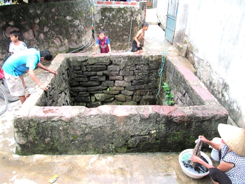
| Discovery: The wall of the well was built with many layers of carved stones. -- Photo courtesy of Trình Năng Chung |
THANH HÓA – Scientists have confirmed their first findings of traces of ancient wells from the Chăm Pa Civilisation in the central province of Thanh Hóa.
Trình Năng Chung, Ph D, from the Institute of Archaeology, acknowledged that his delegation has discovered many wells built in the style of the Chăm Pa civilisation in Nghi Sơn Island, Tĩnh Gia District of the province.
Most of these wells remain intact and are identified due to their square mouths.
The largest well measures 2.9m on each side and has a depth of over 5m. The well is located in Giếng Hamlet, Nam Sơn Village. Its wall was built with thick stones, which were carefully carved. The stones have not been affixed to one another using any materials. The bottom of the well was made smaller than its mouth with stone layers laid like staircases in a square form.
The stone layers are loaded on two thick pieces of wood, which made up the well’s bottom. The water in the well always remains at a depth of 1m. Also, local residents said the water in the well has never dried up, even during serious droughts.
At present, to preserve the well, locals covered gaps between stones with cement and built two staircases outside the well.
Local residents also revealed that there had been some ancient wells near today’s Nghi Sơn Deep Water Port. But the wells were destroyed during the construction of the industrial zone at the port.
A few months ago, residents at Đồn Hamlet, Bắc Sơn Village in the same district, destroyed an ancient well while building a house. There is still a part of the well’s mouth which can be seen.
Prof Chung said beside similar characteristics of forms and building techniques, the wells found here share the same geological features that are found near the ancient coastline.
“This shows the early people’s skills in choosing the underground fresh water source,” Chung said, “Though the wells lie near the sea, their water remain fresh.”
The water sources for the wells have never dried and locals still use them in their daily lives, he noted.
Recently built dams, roads and buildings have encroached on the coastline, in comparison with the past.
Prof Chung confirmed that the wells display defined features from the Chăm Pa civilisation.
The wells might have been built at the same time the Tây Sơn regime built the Tam Điệp and Biện Sơn Defendence System. In 1789, Nguyễn Huệ (1753-1792), who was also known as King Quang Trung, used Biện Sơn as a naval base to send fighting ships to co-ordinate with army troops on land who were marching to Thăng Long Citadel in the north to fight against the troops from the Qing dynasty from China.
In King Quang Trung’s army, there were Chăm Pa ethnic people. They might have helped build the wells in their traditional style, Chung said.
According to historic materials, Nghi Sơn Island was also known as Biện Sơn. The island was compared to a giant arm reaching to the sea, embracing a bay with a proper depth for ships seeking refuge during storms.
The island now is home to the four villages of Thanh Sơn, Bắc Sơn, Trung Sơn and Nam Sơn. The villages are located in the north of the island and are linked with one another by a small path nearly 2km long. The road runs parallel with the coastline in a north-south direction.
The area still hosts various relics from temples, communal houses and traditional festivals dedicated to King Quang Trung.
The term “Champa” refers to a collection of independent “Cham” polities that extended across the coast of what is today’s central and southern Việt Nam from approximately the 2nd century (192) through the 19th century (1832).
The kingdom was known variously as Chăm Pa in Vietnamese (Chiêm Thành in Sino-Vietnamese vocabulary). – VNS
 |
| Old but functional: A well displaying the Chăm Pa civilisation style on Nghi Sơn Island, which is still used by local residents. -- Photo courtesy of Trình Năng Chung |


