 Economy



Sơn La holds second coffee festival, targeting stronger businesses in future
1.
|
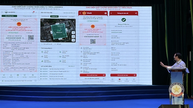
| Đinh Hồng Phong from the Land Administration Department presents a draft digital land use rights certificate during the conference. — VNS Photo Mai Hương |
By Mai Hương
HÀ NỘI — Việt Nam expects to complete a nationwide digital database for all land parcels by the end of 2026 and finish a comprehensive national system of digital land records by 2027, laying the foundation for electronic land use rights certificates and fully online land services.
According to Đinh Hồng Phong, a land database expert at the Ministry of Agriculture and Environment's Land Administration Department, the current method of identifying land parcels relies on administrative boundaries such as provinces, districts, communes and map sheet numbers.
That approach has become increasingly difficult to manage following administrative reforms, including the merger of communes and wards, which require land records to be updated.
"When administrative boundaries are adjusted, we have to spend a great deal of time updating the entire land management system," Phong said at a conference on location data on August 10.
To address the problem, the ministry has developed a unique identifier for each land parcel based on its geographic coordinates rather than its administrative location.
"Every land parcel will have its own identification code, much like every citizen has a VNeID," he said.
Because the code is tied to the parcel's location instead of administrative boundaries, it will remain unchanged even if provinces or communes are merged or renamed.
The identifier also allows authorities and users to locate land parcels directly on digital maps.
Since late 2025, every land parcel added to the national land database has been required to carry a unique identification code. So far, nearly 69.7 million parcels have been digitised and assigned the identifiers, Phong said.
The identifier will serve as the foundation for electronic cadastral records and electronic land use rights certificates, replacing today's paper certificates commonly known as "red books".
"We are moving from managing land through paper records to managing it through data," Phong said.
Under the new system, each land parcel will carry a unique 12-character identifier, allowing users and authorities to instantly access its digital record, including ownership, legal status, planning information and transaction history.
The digital certificates are also expected to curb document forgery and prevent the same certificate from being used repeatedly in fraudulent transactions, as all information will be verified against the central database.
Phong said the reform would also make fully online land services possible.
At present, many procedures still require people to submit paper certificates in person, preventing transactions from being completed entirely online.
Once land records and certificates are digitised, users will be able to carry out procedures such as ownership transfers, mortgage registration and tax payments electronically.
The land database is being linked with the national population, tax and housing databases to support integrated public services.
Authorities are also working with the Ministry of Public Security to integrate electronic land certificates into the VNeID application, allowing land users to securely access their property information on a single platform.
Phong said the national land database is scheduled for completion by the end of 2027, after which people are expected to access land information digitally without having to visit land administration offices.
Speaking at the conference, Major General Nguyễn Ngọc Cương, director of the Ministry of Public Security’s National Data Centre, said location data should be regarded as strategic national infrastructure rather than simply a technical tool.

|
| Major General Nguyễn Ngọc Cương, director of the Ministry of Public Security’s National Data Centre, speaks at the conference. — Photo vietnamplus.vn |
"People are identified, assets are identified, and locations must also be identified," Cương said.
He added that a standardised location identification system would allow government agencies to share data more effectively while supporting urban planning, construction management, logistics, e-commerce, emergency response and artificial intelligence applications.
Cương said the focus should not only be on collecting data but also on ensuring that it can be shared and used effectively.
"The requirement is not only to collect data but also to build foundational datasets, common standards and governance mechanisms so data can be connected, shared and used," he said.
He added that improving legal frameworks and ensuring high-quality data would be essential to building a modern national data infrastructure.
"The institutional framework is already in place," Cương said.
"The challenge now is not creating more policies, but making them work."
The conference marked the launch of a dialogue series on Việt Nam's strategic data infrastructure hosted by the National Data Association (NDA) in collaboration with the Vietnam Data Expert Network (VDEN).
The following discussions are expected to centre on sectors such as construction, healthcare, logistics, energy, environment, tourism and finance.
The series aims to support the development of an integrated national data ecosystem, facilitating the implementation of the Data Law and fostering the growth of Việt Nam's data industry. — VNS
Economy
 Economy
 Economy
 Economy
 Economy
 Economy
 Economy
 Economy
 Economy
 Economy
 Economy
 Economy
 Economy
 Economy
 Economy