 Society

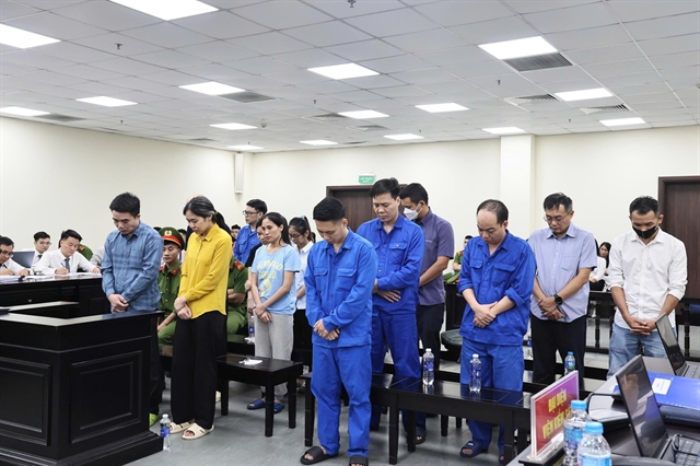
Former pharmaceutical chairman faces 18 years in prison over counterfeit health supplement case
1.
Hải Anh & Thu Vân
HÀ NỘI — As torrential rain lashed the northern province of Thái Nguyên late on October 7, Nguyễn Thị Mai Anh, an AI specialist based in Hồ Chí Minh City, noticed Facebook overflowing with urgent pleas for help — families trapped on rooftops, homes swallowed by floodwater, power lines down.
She messaged her friend Từ Tất Huân in Hà Nội, urging that they take action together.
“When people are terrified, they turn to every communication channel they can find - Facebook, comment sections, even groups unrelated to the floods - simply because they’re panicking,” Huân said.
The two friends, hundreds of kilometres apart, decided to act. Soon after, Đặng Long, another technology engineer, joined their effort.
Working through the night, they spent five hours developing an online rescue map to locate and visualise calls for help from flood-hit areas in real time. By 4 am, the first version of the map was ready to use.
"The key was to make it easy for everyone to see which areas urgently required help or supplies,” Huân explained.
Building through the night
Mai Anh described how it all began in a rush that night, when the online community was overwhelmed by cries for help.
“At first, we searched manually. There were so many posts on big pages and community groups where people were updating the situation in their areas," she said.
"We then built a data pipeline that collects posts every ten minutes, processes them through AI to verify if they relate to rescue requests or floods, extracts the addresses, and plots them on the map.”
Instead of creating a mobile app, which many people, especially the elderly, would find difficult to install, they decided to collect information directly from social media.
“Most people posting on social networks are middle-aged or older. They’re not used to downloading new software or sharing their location through apps, but everyone knows how to post or comment on Facebook. That’s why we chose to gather data from Facebook rather than build a separate app,” Huân said.
They also discovered that internet connections in flooded areas were extremely weak.
“It often took several attempts just to upload one post, so downloading even a small app would have been nearly impossible. That’s why we built a website instead, accessible to anyone without installation,” he said.
By dawn, their first version was running. By 8 am, it already had 3,000 users. By the end of 9 October, that number had reached 27,000.
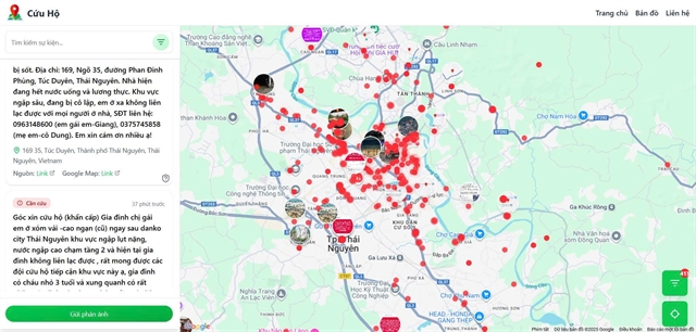 |
| A screenshot of thongtincuuho.org showing the real-time heatmap of rescue requests. |
Mapping hope
The platform analyses public posts and comments, displaying them on a heatmap that shows where flood victims most urgently need help.
Red zones indicate heavily affected areas, while isolated 'cold' zones mark where only a few people are stranded and might otherwise be overlooked.
“I saw rescue teams commenting that they were using the map to plan routes. It became a helpful support channel, offering extra data when official information couldn’t keep up. In Việt Nam, social media often spreads faster than news outlets, so these posts are invaluable during disasters,” said Mai Anh.
For her, the experience reaffirmed the power of collaboration between technology and human compassion.
“If government or authorised agencies could release similar tools, it would make it much easier for citizens to connect with the right rescue teams and share reliable information,” she said.
Huân emphasised that the goal wasn’t to produce a public list of addresses for anyone to rush to. Sometimes, people could no longer be reached, or they had already been evacuated.
“The map simply visualises which areas have been most affected in the past 24 hours. From there, professionals can make their own judgments. Our next step is to expand support to all provinces hit by floods. We’ve optimised it so that adding a new province takes just five minutes.”
 |
| Từ Tất Huân and Nguyễn Thị Mai Anh stayed up through the night to create a live online map that tracked rescue calls in real time. — Photo courtesy of Từ Tất Huân and Nguyễn Thị Mai Anh |
An idea born in gridlock
Long before the floods, the idea for mapping crises began in a traffic jam.
Severe flooding had once paralysed major roads in Hà Nội for hours. Sitting helplessly in his car, Huân, a software engineer with nearly a decade of experience, began thinking about how technology could ease such moments of paralysis.
“When I was stuck in traffic for five hours on Trần Duy Hưng Street in Hà Nội, I thought: why not create a tool to visualise traffic in real time, so people know where to go and what to avoid?” he said.
That night, he opened his laptop in the car and began coding the first version of vntraffic.app, an interactive map showing real-time road conditions.
His frustration with delayed radio updates from his wife, never quite matching his location, inspired the need for instant, crowd-sourced data.
What began as a traffic map would later become a lifesaving flood rescue tool.
But running the website came with challenges.
“Using map data on a private website isn’t free. It costs about three to seven dollars per 1,000 users. On the first day, my bill hit 70 dollars, which shocked me,” Huân said.
Support soon arrived.
“Generous sponsors like Vietmap contacted us and offered free map services to support the project. It was a relief.”
But the emotional strain remains the hardest part.
“The more users there are, the more you realise they represent real people in danger. Sometimes I can’t bring myself to look at the numbers or read the comments, because there are so many heartbreaking cases we can’t reach,” Huân admitted.
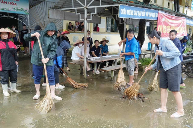
From a night of chaos and despair emerged a symbol of unity between code and compassion. What began as a spontaneous idea between two friends became a lifeline for thousands of flood victims, proving that in moments of crisis, technology can carry both data and hope. Beyond the immediate impact, their story highlights the growing power of Việt Nam’s young tech community to mobilise quickly, bridge information gaps, and create solutions. In the face of climate change and increasingly unpredictable disasters, this kind of citizen-driven innovation could become an essential part of the country’s resilience. — VNS
Society
 Society
 Society
 Society
.jpg) Society
Society
 Society
 Society
 Society
 Society
 Society
 Society
 Society
 Society
 Society
 Society