 Society


Việt Nam advances deep processing with first aluminium ingot production
1.
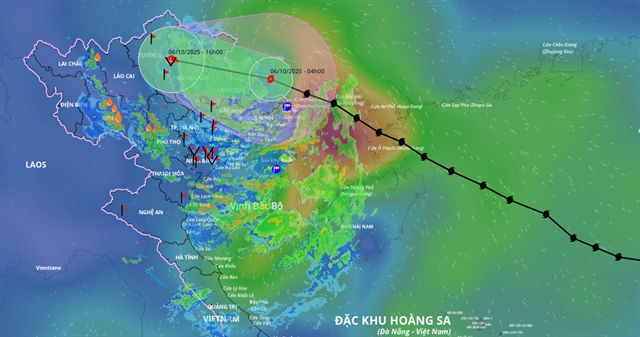 |
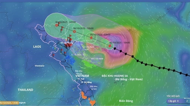
| The projected path of Typhoon Matmo. |
HÀ NỘI — Early this morning, Typhoon Matmo – the 11th storm to enter Việt Nam’s East Sea this year – has moved inland over Guangxi Province, China, on Monday morning and weakened to level 8 (62–74 km/h) with gusts up to level 10 (89–102 km/h), according to the National Centre for Hydro-Meteorological Forecasting.
The storm is expected to continue moving further inland and weaken into a tropical depression by this afternoon, before dissipating into a low-pressure area over the northern mountainous region of Việt Nam.
Due to the storm’s circulation, strong winds will persist today across the northern border provinces of Quảng Ninh and Lạng Sơn, with speeds of level 6–7 and gusts up to level 9. Elsewhere in northern Việt Nam, strong winds are not expected to be significant.
While wind impacts to Việt Nam dwindled as the storm moves northward, Typhoon Matmo continues to bring heavy rainfall to northern provinces and Thanh Hóa from now until the night of October 7.
The heaviest rains are forecast in the northern mountainous and midland areas, with totals ranging from 100–200mm and some locations exceeding 300 mm. In the Red River Delta and Thanh Hóa, rainfall is expected at 50–150mm, with isolated areas seeing over 200 mm.
Authorities warn of a very high risk of flash floods, landslides in mountainous regions, and flooding in low-lying and urban areas — particularly in Lạng Sơn, Cao Bằng, Tuyên Quang and Lào Cai.
Forecasters note that rainfall caused by the storm’s circulation will occur in intervals. Residents are advised not to let down their guard even if it is not raining at certain times during the day.
Hà Nội is not expected to suffer widespread flooding as seen on September 30 in the wake of Typhoon Bualoi (Storm No.10) but inundation will happen in low-lying areas.
Earlier, Hà Nội authorities have decided to suspend classes for 2.3 million preschool and general education students to ensure safety, after the belated decision to shut schools on September 30.
In coastal and northern provinces, including Hải Phòng, Hưng Yên, Quảng Ninh, and Ninh Bình, local governments have banned vessels from going out to sea and temporarily suspended new departure permits for fishing and transport boats.
Elsewhere, from Nghệ An to Lâm Đồng and across the southern region, rainfall is expected to be minimal today. From Quảng Trị to Đà Nẵng and the eastern parts of Quảng Ngãi to Lâm Đồng, the weather will remain sunny and relatively hot, with daytime temperatures ranging from 32–34 degrees Celsius.
By late afternoon and evening, scattered thunderstorms are likely over the Central Highlands and southern provinces, with some areas experiencing heavy downpours accompanied by lightning. — VNS
Society
 Society
 Society
 Society
 Society
 Society
 Society
 Society
 Society
 Society
 Society
 Society
 Society
 Society
 Society
.jpg)