 Society


Việt Nam's top logistics show opens in HCM City, showcases AI, green supply chains
1.
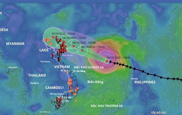 |
| The location and forecast trajectory of Typhoon Matmo as of 4pm on Saturday. — VNA/VNS Photo |
HÀ NỘI — Typhoon Matmo is moving north-northwest with a maximum sustained wind speed of 133km/h with level-15 gusts (167-183km/h).
As of 4pm on Saturday, the storm is approximately 290km northeast of Hoàng Sa Special Administrative Zone (Spratly Islands). It is the 11th storm to enter the East Sea this year.
According to the National Centre for Hydro-Meteorological Forecasting (NCHMF), Matmo is likely to make landfall in the area between Quảng Ninh Province and Guangxi (China) around Monday afternoon.
“Typhoon Matmo has a wide circulation, so even before it makes landfall or has a direct impact, it can still induce thunderstorms which could significantly affect residents and properties, particularly in the Gulf of Tonkin and across the northern region,” said the NCHMF’shead of weather forecasting department Nguyễn Văn Hưởng.
Heavy rainfall is expected in the northern mountains and midlands from Sunday night until Tuesday, with rainfall totals ranging from 150-250mm, and some areas exceeding 400mm.
The northern delta region to Thanh Hóa Province are forecast to have moderate to heavy rain.
Hà Nội is unlikely to experience strong winds from the typhoon but can expect downpours from early Monday morning until Tuesday night.
Explaining the typhoon’s intensification upon entering the East Sea (internationally known as the South China Sea), Hưởng noted that the storm encountered relatively favourable conditions during its movement.
The current sea surface temperature in the East Sea is around 28-29 Celsius degrees, which is more conducive to storm intensification compared to the average threshold of 26-27 degrees Celsius.
Additionally, the low wind shear at sea allowed moisture to accumulate, contributing to the storm’s structural development.
Matmo is expected to strengthen over the next 24 hours. However, as it moves past the northern part of China’s Leizhou Peninsula and enters the Gulf of Tonkin, increased land friction and higher wind shear in the region is forecast to weaken the storm. — VNS
Society
 Society
 Society
 Society
 Society
 Society
.jpeg) Society
Society
 Society
 Society
 Society
 Society
 Society
 Society
 Society
 Society