 Society
The mudflats in the middle of and along the river are not far from the pedestrian streets around Hoàn Kiếm Lake. While the current pedestrian space has been overloaded, the mudflats could be another choice for entertainment activities.
|
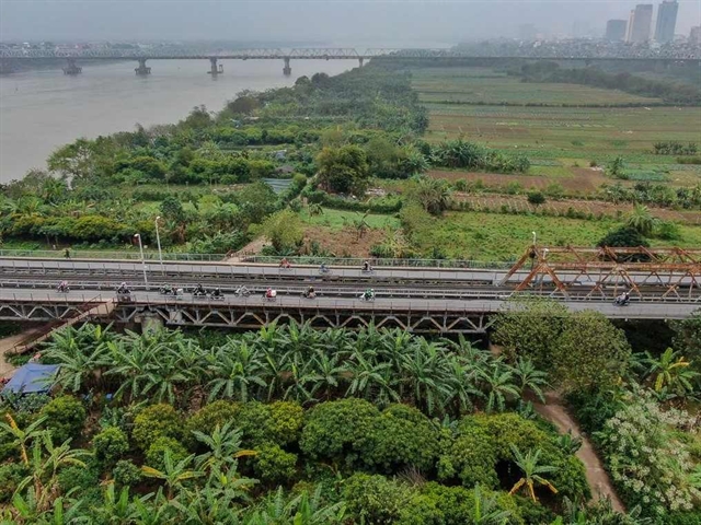
| Mudflats in the middle of Red River are mostly used to grow vegetables. — VNA/VNS Photo |
HÀ NỘI — Mudflats on the Hồng (Red) River in Hà Nội have great potential to become green parks for tourism or community space.
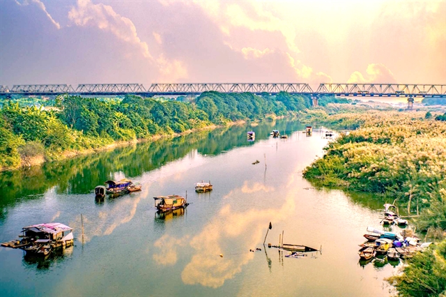
Located in the Red River cultural space, in harmony with the landscape on both banks and the historic Long Biên Bridge, the mudflats are under the management of many wards including Tứ Liên, Yên Phụ (Tây Hồ District), Phúc Xá (Ba Đình District), Phúc Tân, Chương Dương (Hoàn Kiếm District) and Ngọc Thụy (Long Biên District).
The mudflats in the middle of and along the river are not far from the pedestrian streets around Hoàn Kiếm Lake. While the current pedestrian space has been overloaded, the mudflats could be another choice for entertainment activities.
The mudflat in the middle of the Red River is an alluvial land formation built up over many years with an area of about 23 hectares, covered mostly with trees and vegetable fields.
The area has been mainly used to grow vegetables with lots of abandoned space.
Urban development in Việt Nam and around the world is often associated with rivers. Hà Nội is closely linked with the water surface system, specifically the Red River.
Over time with geographical and human changes, the Red River has become deeply embedded in the life of the city.
Not only one of the five urban heritage elements, besides old street, old town, historical monuments, urbanised villages, lake and pond system that bring values to a large city like Hà Nội, the river holds a prominent place in the memory in many generations of Hanoians.
The city has joined the UNESCO Creative Cities Network while the Red River Urban Subdivision Planning has been approved.
According to experts, these are favourable conditions to develop the Red River into an important landscape axis, especially the area in the middle of the river, in order to create a landscape architectural space, a creative and cultural area.
Architect Trần Ngọc Chinh, chairman of the Việt Nam Urban Planning and Development Association, said this orientation will be the foundation to make the Red River a natural and unique highlight of Hà Nội’s urban area in the future.
He said the mudflat area’s planning must pay special attention to connecting the core elements of nature, culture and social community, because the area is not only a natural space for relaxation and health exercise, but also a place for cultural activities and social exchanges.
|
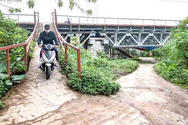
| Two stairways from Long Biên Bridge offer access to the mudflats. — VNA/VNS Photo |
Good planning and design not only help enhance the quality of urban living, but also make the city more sustainable, he said, adding that it is necessary to pay attention to the impact of an urban area on the environment, especially the load-bearing capacity of the mudflats, when this place becomes a cultural location and entertainment centre.
The mudflat area, once turned into a park, will be a tourist attraction in the Old Quarter, and control encroachment in the middle and on the banks of the Red River, he said.
International experience
|
| Mudflats along the Red River. — VNS Photo Stu Edd |
Nguyễn Đỗ Dũng, general director of enCity International Consulting Company, the planning unit of Thủ Đức Creative Urban Area in HCM City, said building a park in the middle of the Red River is a great opportunity for Hà Nội to create green space right in the heart of the city.
Sharing international experience, he said the world has many good models. China has many such models, typically the riverbank at Puyangjiang River Corridor in Zhejiang province where they have built pedestrian bridges to the mid-river flats, opening a green space attracting many tourists.
He cited Long Biên Bridge as an example of possibly being turned into a pedestrian bridge which will act as a connection between the bank and the mudflats in the middle of the Red River.
In Japan and Taiwan (China), river mudflats are places of tourism activities, football fields, golf courses. When the water rises, all activities stop. Investors must be responsible for maintenance after the flood recedes, but in return, they have extremely favourable locations for businesses, he said.
In Singapore, they plant trees, make modern nets, release birds, and create an experience space for tourists, he said.
Architect Phan Đăng Sơn, chairman of the Vietnam Association of Architects, said in addition to the bridge system, the city should focus on building underground traffic routes under the river to connect urban areas on both banks.
He said the mudflat area must be developed with high-tech agricultural ecological planning to preserve unique regional connections.
Architect Nguyễn Bá Nguyên, deputy director of the Hà Nội Department of Planning and Architecture, said the city’s authorities will study a detailed plan to turn the mudflats in the middle of the Red River into a multi-functional park. The authorities will need to be granted special policies to remove obstacles in detailed planning.
Tạ Nam Chiến, chairman of Ba Đình District People’s Committee, proposed building squares in the park. The park space needs to be connected with nearby famous spots like Long Biên Bridge, Đồng Xuân Market and Hàng Đậu Water Tower.
Nguyễn Mạnh Hà, chairman of Long Biên District People’s Committee, expected the project will change the surrounding area's appearance and potential with such a major open community space.
The mudflats have both an urban cultural function and the function of ensuring flood drainage. Agencies need to be careful to respect nature. Planning must minimise concrete and prioritise environmentally friendly materials. In any plan, Long Biên Bridge must always be identified as an important and vital symbol, he said.
Nguyễn Đình Khuyến, chairman of Tây Hồ District People’s Committee, said in the context of limited local budget, the authorities should call for investment from enterprises and community in the park. — VNS