 Environment

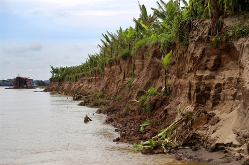
The threat of landslides, particularly during the rainy and stormy seasons has concerned residents who live along the west bank of the Hồng (Red) River in Hà Nội.
 |
| Landslides occurred along the Hồng (Red) River in northern Phú Thọ. Riverside residential areas in Hà Nội are also facing at risk from landslides. — VNA/VNS Photo Trung Kiên |
HÀ NỘI — The threat of landslides, particularly during the rainy and stormy seasons has concerned residents who live along the west bank of the Hồng (Red) River in Hà Nội.
Early this month, a riverside house in Bạch Đằng Ward, Hoàn Kiếm District collapsed because of a landslide. About ten nearby houses are also vulnerable to collapse and cracks appeared on roads there.
Nguyễn Văn Bình, owner of the collapsed house, said that his family had lived there for a decade.
They were still traumatised by the collapse and felt lucky none of them were at home when the house collapsed.
Now, he has to pay VNĐ3 million (US$134) a month for a rental house.
Nguyễn Bích Phượng, Bình’s neighbour, said that she was worried as now her house was closer to the river.
Lê Bích Hằng, chairwoman of Bạch Đằng Ward People’s Committee said that local authorities could do nothing but urge families in dangerous areas to move to safer areas.
Local authorities could not arrange resettlement for landslide-hit households because they had no land available for resettlement, she said.
The ward saw landslides after heavy rains in 1996, 1997, 2003 and 2012, affecting an apartment building and police station.
In 2012, Hà Nội municipal People’s Committee started building stone embankments but they have not been completed yet due to funding shortages.
Last month, following storm Dianmu, landslides also struck other sections of the Hồng River’s west bank, affecting hundreds of families.
A 200 metre landslide hit Vân Cốc Dyke in Thọ An Commune, suburban Đan Phượng District. Walls cracked in at least three houses.
Along a 1-km part of Red River’s west bank from Sơn Tây Town’s Đường Lâm Commune to Ba Vì District’s Cam Thượng Commune, about 20 spots suffered serious landslides.
Vice director of Hà Nội’s Agriculture and Rural Development Department, Hà Đức Trung, said that the adjusted water flow to serve waterway transport to Hà Nội Port affected west bank of Red River.
The river’s west bank sloped and was yet to be embanked, so it was vulnerable to landslides, Trung said.
Trung said that the agriculture department asked municipal committee to launch a project on the Red River’s west bank embankment in three wards of Chương Dương, Thanh Lương and Bạch Đằng.
The project is expected to curb landslides in riverside residential areas. — VNS


