Features

Việt Nam-Laos trade targets US$10 billion
1.
Both the Government and locals working with a USAID project are mapping out potential sources of disaster so that communities can prepare for potential calamities better in the future. Hà Nguyễn reports.
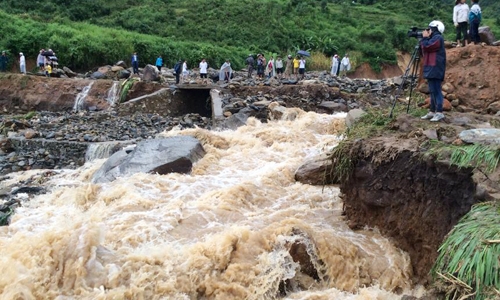 |
| Calamity: A landslide caused by flash flooding in the northern province of Tuyên Quang. Photo baotuyenquang.com.vn |
by Hà Nguyễn
Việt Nam is among the five countries most affected by high rates of natural calamity in the world. It has experienced great loss of human life and property damage, according to the Asian fund for the prevention and fight against natural calamity.
To address the problem, the Ministry of Natural Resources and Environment has directed related agencies to build a system of maps warning of natural calamity and to issue these maps to areas of provinces and cities that are commonly affected by floods, whirlwinds, landslides and dangerous cold snaps.
Based on these maps with a scale of 1/50,000, natural calamity preparedness offices of these districts have implemented works at relevant communes.
Along with this official map system, another map system has been implemented by local people, according to the website of the Centre for Preventing and Reducing Natural Calamity.
“Locals draw on local maps dangerous areas that could be affected by flash floods or ways to escape a severe storm,” said the centre’s director Nguyễn Hữu Phúc.
Prominent among the affected provinces is the northern province of Nam Định, based on maps drawn by the community to deal with natural calamities.
Nguyễn Công Chức, head of a project funded by the USAID, said building maps at the community level was very important to define long-term plans to prevent and fight against natural calamities in the locality.
"The map localises concrete areas and evaluates locations that could be affected by floods and storms or provide a safe shelter for people. The most interesting thing about the maps are they are created by locals so they are very concrete and understandable because they have had experience of the spot," said Chức.
Phạm Thị Sang in Nam Định’s Trực Định Commune said she and her neighbours were trained to know the harm caused by floods so they were excited to join in drawing a map because they know very well the roads to safe places to escape storms and floods. " We place importance in this because it directly affects our lives."
She said she was thankful for being trained as many locals have changed their habits by serving rice and money as ways to take care of the elderly and disabled during flood season.
Sang’s neighbour Lê Văn Tươi, 68, is a good consultant to agencies in charge of drawing a map in the most correct way.
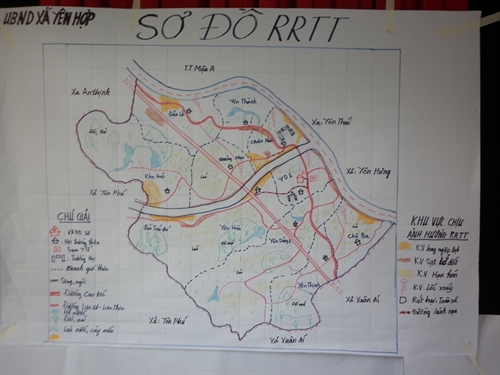 |
| Danger zone: A map drawn by locals in Yên Hợp Commune, Văn Yên District, of Yên Bái Province. Photo dmc.gov.vn |
Currently, USAID has supported Nam Định’s 24 communes to build the maps while setting up community-based groups to deal with natural calamities. The project has also supplied rescue equipment for times of calamity and guides local people to strengthen their houses for safety and to think ahead of how to deal with natural calamities that could occur.
Đỗ Ngọc Huỳnh, chairman of Giao Hải Commune in Hải Hậu District, said his commune strictly carried out training on how to prevent and fight against calamity.
Local authorities in charge have been preparing "four works on the spot" training, such as being able to ready forces, rescue materials, equipment and logistics on the spot quickly.
As a result, the coastal commune of Giao Hải faced very few losses caused by Mirinae, the first storm of 2016, compared with other communes because of the careful preparations they had made beforehand.
Nguyễn Quốc Thành of the Geology Institute who is in charge of creating the maps warning of potential natural calamities, said the maps helped inhabitants and local authorities know about and prevent losses caused by natural calamities.
According to this map, the northwestern province of Lào Cai has 534 areas threatened by landslides. Much more important is that there has already been a small landslide on the side of a mountain top in Nậm Bắt Hamlet of Tân Tiến, but the map shows that the cracked mountain is expected to bring a much greater disaster.
The institute has built maps of especially dangerous areas in the provinces of Yên Bái, Lào Cai, Lai Châu, Lào Cai and Điện Biên.
It is expected that the detailed maps will be finished by 2020, he said.
The northwestern province of Sơn La is often faced with severe flash floods and landslides that have badly affectedits economic development and caused great losses to locals’ property and lives.
To deal with the problem, the province has applied GIS (a combination of IT and map technology) to build a map system that warns of flash floods and landslides over the entire province, and authorities can use these maps to build a long-term strategy for natural calamity preparedness, said Thành.
Meanwhile, departments of natural calamity prevention in the central and southern regions have delivered maps and trained locals on how to deal with floods due to sea level rises in the provinces of Ninh Thuận, Khánh Hòa, Bình Thuận, Phú Yên, Đồng Tháp and Tiền Giang.
The Minister of Natural Resources and Environment Trần Hồng Hà says, "The maps have helped to define dangerous areas and areas that are being threatened with landslides that could affect inhabitants, transport and local economic development. The data in the maps are very important to serve works on the prevention, and reduction of losses caused by landslides during floods and storms in Việt Nam’s mountainous areas." VNS
Features
 Features
 Features
 Features
 Features
 Features
 Features
Now at the age of 85, veteran teacher Nguyễn Trà has devoted himself to teaching poor and disabled students for almost 25 years.
 Features
A group of high-school students within Hà Nội have got together to conduct Lọ Mọ, a project that aims to raise children's awareness of environmental protection and recycling.
 Features
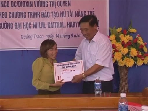
Returning home for summer holiday after two years studying in India, 27-year-old Vương Thị Quyên from Thanh Lương Hamlet, Quảng Xuân Commune, in the central province of Quảng Bình, is as determined as ever to leave her mark on the world.
 Features
While other groups and organisations support poor children by donating money, food or books, Make A Simple Wish group chooses education to help.
 Features
When night falls, some of the most crowded places in HCM City are street food markets that attract hundreds of visitors from around the world. Minh Hương checks out some of the better-known spots.
 Features
The first-ever Human Library project has just opened in Hà Nội’s Labour and Society College.
During the two days it ran, the “living library” attracted more than 500 “readers” and received encouraging feedback.
 Features
Despite her handicap, the 21- year-old Lê Hương Giang has been an outstanding student and travelled to different remote regions of the country to help disabled children and their families.
719124604PM.jpg) Features
Features
Flute kites are a centuries-old game that attracts people of all ages and professions. Song An Commune is preparing for its annual flute kite festival and keeping an ancient tradition alive.
 Features
Ding Dong is the new gong in Kon Klor Village of Kom Province. Kaly Tran has almost single handedly revived the Tay Nguyen(Central Highlands) music of the Ba Na
people, and is now spending his time leading a musical troupe of his own. Moc Mien reports.