 Society

Podul storm was moving quickly and entered the South China Sea (called East Sea in Việt Nam) early Wednesday.

|
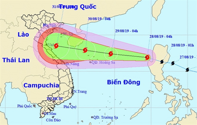
| Podul storm could hit Viet Nam by next week causing heavy rain in the north. Photo courtesy of the National Centre for Hydro-meteorological Forecasting |
HÀ NỘI — Podul storm is moving quickly and entered the South China Sea (called East Sea by Việt Nam) early Wednesday.
The National Centre for Hydro-meteorological Forecasting predicts the storm would continue to strengthen and possibly enter the Tonkin Gulf in the next 2-3 days.
The centre reported the storm has passed Luzon Island off the Philippines, and has level eight wind speeds of up to 74km an hour. It is the 4th storm in the East Sea this year.
In the next 24 hours, the storm is predicted to move quickly in the west-northwest direction at a speed of 30km per hour and is likely to become stronger.
By Thursday morning, the storm’s eye is expected to be about 240km east of the Hoàng Sa (Paracel Islands) with the wind speed at level eight or nine (75 to 88km per hour), according to the centre.
The storm will keep moving in this direction at a reduced speed of 15-20km per hour but still have the ability to become stronger.
On Saturday, the storm’s eye is forecasted on the southern sea of Tonkin Gulf with the wind speed at level 9-10 (89-102 km per hour).
The National Centre for Hydro-meteorological Forecasting predicted the Podul storm can reach Việt Nam’s waters and land, affecting the north and the north-central coast areas during the National Day holiday (September 2).
The National Steering Committee for Disaster Prevention and Control has urgently requested localities from Quảng Ninh Province to Phú Yên Province to closely monitor weather changes to take proactive steps to keep people and assets safe.
The provincial committees should coordinate with related departments and local authorities to control off-shore fishing and keep in contact with vessels operating in the storm-affected sea areas.
Due to the impact of the storm, on Wednesday evening, the northern region will be hit with showers, and heavy rains and winds in mountainous areas. — VNS


