 Society


Hà Nội expands smart traffic system with 36 LED displays
1.
|
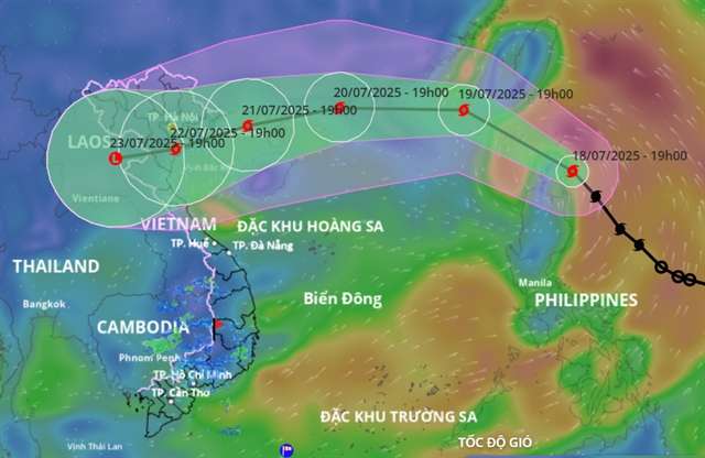
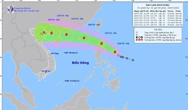
| Forecasted path of Typhoon Wipha over the next few days. — Photo vndms.dmc.gov.vn |
HÀ NỘI — Typhoon Wipha is expected to intensify as it moves into the East Sea (internationally known as the South China Sea), with forecasts showing it could make landfall in northern Việt Nam as early as July 22, bringing heavy rain and strong winds across a wide area.
The Ministry of Agriculture and Environment convened an emergency meeting on Friday to prepare for the storm, which is likely to become the third tropical cyclone to enter Vietnamese waters this year.
"From the start of the year, we’ve seen unusual weather patterns. Wipha is expected to bring heavy rainfall once it reaches land," said Deputy Minister Nguyễn Hoàng Hiệp.
According to Mai Văn Khiêm, Director of the National Center for Hydro-Meteorological Forecasting, Wipha has been moving northwest at about 20 km/h, with developing convective clouds indicating a favorable environment for the storm to grow stronger.
"It will likely enter the East Sea by the morning of July 19 and be officially designated as Typhoon No.3. There is a high probability – over 90 per cent – that it will continue to intensify," Khiêm said.
Forecasts show the storm could bring gusts up to Beaufort Force 15 (167-183 km/h) as it passes near Leizhou Peninsula (China). By the time it impacts Việt Nam’s northern coast on July 22, wind speeds could reach Beaufort Force 11 (103–117 km/h).
However, Khiêm noted that current weather models show significant variation in the storm’s potential path, with landfall estimates differing by up to 100 km. Rainfall and wind impacts will depend heavily on the storm's actual trajectory.
As early as July 20, outer rainbands may bring scattered thunderstorms. From July 21 to 24, Wipha is forecast to cause widespread heavy rain across Northern Việt Nam and parts of North Central Coast, especially from Quảng Ninh to Nghệ An.
Rainfall totals are expected to reach 200–350 mm, with some locations possibly approaching 500–600mm. These projections remain preliminary and are expected to be updated as the storm nears.
If Wipha tracks further north along the Chinese coast, its effects on Việt Nam could be reduced. Updated forecasts are expected in the emergency storm bulletin on July 20.
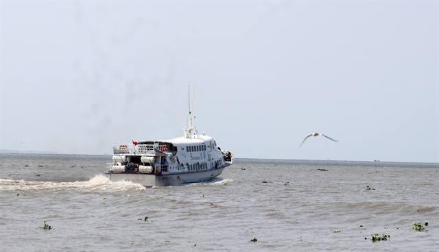
Nguyễn Trường Sơn, Deputy Director of the Vietnam Disaster and Dike Management Authority, reported that as of 11.00 am on July 18, more than 35,000 vessels and 147,000 crew members had been notified and counted.
"There are no vessels currently operating in the northeastern part of the northern East Sea, which is expected to be most affected by the storm," Sơn said.
Authorities are also closely monitoring major hydropower and irrigation reservoirs. At Hòa Bình Reservoir, three spillway gates are open to bring the water level down from 102.94 m to the seasonal flood safety level of 101 m. A similar drawdown is underway at Tuyên Quang Reservoir.
Officials are urging people to remain vigilant, stay informed through official updates and prepare for potential disruptions as the storm moves closer to shore. — VNS
Society
Society
 Society
 Society
 Society
 Society
 Society
 Society
 Society
 Society
 Society
 Society
 Society
 Society
 Society