 Society

 |
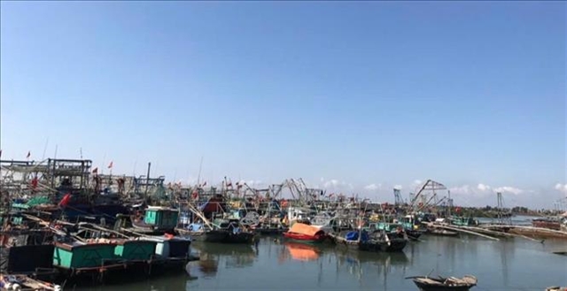
| Over 2,200 boats and vessels in Quảng Yên Town have been advised to seek safe shelter ahead of the storm's landfall. — VNA/VNS Photo |
HÀ NỘI — Vân Đồn International Airport in Quảng Ninh Province will halt all aircraft operations from 4am to 4pm on Saturday.
This temporary suspension comes as a precautionary measure against the looming threat of Super Typhoon Yagi, which is expected to bring intense winds and severe weather, posing a significant risk to airport safety.
Two scheduled Vietnam Airlines flights, set to land at 8:05am and depart at 8:50am on Saturday, will be cancelled as a result.
The airport is working closely with Vietnam Airlines to notify affected passengers and relevant service providers.
In preparation for the storm, Vân Đồn International Airport is undertaking several protective measures, including securing equipment, dredging drainage systems and activating storm response plans as outlined by provincial authorities.
Quảng Ninh Province has also imposed a sea ban starting at 11am on Friday.
The Department of Transport, the Quảng Ninh Maritime Port Authority, the Inland Waterway Port Authority and coastal local authorities have suspended all maritime activity, prohibiting vessels from setting sail.
According to the provincial hydrometeorological station, as of 4am on Friday, the eye of Super Typhoon Yagi was located over the northern waters of the East Sea at approximately 19.2 degrees north, 112.7 degrees east, or around 200 kilometres east-southeast of Hainan Island, China, and 620 kilometres southeast of Quảng Ninh.
With maximum sustained winds around the eye at level 16 (184-201km per hour) and gusts exceeding level 17, the typhoon was moving west at around 20km per hour.
By midday on Friday, strong outer winds reaching level 6-7 are expected to develop in the eastern part of the Gulf of Tonkin, including over Bạch Long Vỹ Island.
By the evening, these winds will intensify to level 8-9, increasing further to level 10-11, with areas near the typhoon’s centre experiencing winds at level 12-14 and gusts exceeding level 17. Rough seas are expected to follow.
The typhoon is forecast to make landfall in Quảng Ninh from midday through Friday afternoon, bringing strong winds to the Cô Tô-Đảo Trần sea region and the island communes of Vân Đồn District.
Winds in the northern region are expected to increase gradually to level 6-7, before reaching level 10-11 near the storm’s centre, with gusts at level 14-15.
Heavy rainfall is predicted from Friday night until the morning of September 9 (Monday), with expected amounts ranging from 200 to 300mm across the province, and some areas potentially seeing over 400mm.
This could lead to flooding in rivers and streams, traffic disruptions and inundation in low-lying areas and urban centres. Flash floods and landslides may occur in high-risk zones, particularly in construction areas and coal waste dumps.
The storm's wide-reaching effects may trigger thunderstorms, tornadoes and strong gusts both before and during landfall. — VNS


