 Society


Market gains for three days in a row on buying demand
1.
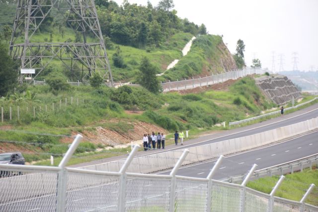 |
| Inspection team examines flooding point on Dầu Giây - Phan Thiết expressway. — VNA/VNS Photo Nguyễn Thanh |
HÀ NỘI — The Dầu Giây – Phan Thiết Expressway in the south-central province of Bình Thuận was flooded due to heavy rain, the narrowing of the Phan River's flow and inadequate design consideration for drainage capability.
This information was reported by the Ministry of Transport (MoT) this week when addressing the reasons behind the 100-metre section of the Dầu Giây – Phan Thiết Expressway in Hàm Tân District being submerged by 0.7 metres.
Following the incident on July 29, the ministry established a task force comprising specialised agencies, construction companies, consultants, and hydrological experts to conduct on-site inspections and review design documents.
This section of the road is situated near the Phan River and is approximately 8.6 kilometres upstream from the Phan River dam.
In general, dams often lead to changes in the downstream flow patterns after being put into operation.
During the construction process, the involved parties adhered to the design documents and ensured quality requirements. The consulting firm surveyed the peak flood level of the Phan River in 1992 (43.14 metres) to construct a culvert, aimed at facilitating water drainage in the area.
At the time of the flooding, the amount of rainfall had not reached the calculated frequency, but the water level had risen to 45.23 metres, surpassing the historical flood peak, which was an unusual occurrence.
From the position of the culvert to downstream, the Phan River had been encroached upon by vegetation, and sediment and sand had accumulated, narrowing the water flow. This resulted in the water level at the culvert area rising, leading to overflow onto the road.
However, one reason given by the MoT is that the consulting unit did not fully account for the narrowing of the river's flow, leading to localised water congestion.
Regarding the solutions, experts have proposed immediate actions to address obstacles in the riverbed to the downstream from the culvert position of the Phan River bridge to enhance water drainage capability for the area.
Currently, this plan is being implemented by the construction unit, with costs paid by the consulting unit.
For the long-term solution, the MoT has requested the project's investor, the Thăng Long Project Management Board, to hire specialised consulting firms to conduct surveys, calculations, and build a model for the entire area. This will help determine the water level corresponding to the project's design.
If necessary, the ministry will consider raising the road in the flooded area if the calculated height exceeds the current level.
The Ministry of Transport has also mandated a comprehensive review of design documents for ongoing expressway projects, especially those located in geologically fragile areas or with complex hydrology, to promptly make adjustments.
The Ministry will strictly handle units that fail to adhere to the contracted quality standards.
The Phan Thiết – Dầu Giây Expressway, connecting Đồng Nai and Bình Thuận provinces, spans 99 kilometres, with six lanes and a top speed of 120km per hour.
It has significantly reduced travel time for vehicles between HCM City and Phan Thiết to just over two hours, compared to the previous 4-5 hours. — VNS
Society
 Society
 Society
 Society
 Society
 Society
 Society
 Society
 Society
 Society
 Society
 Society
 Society
 Society
 Society