 Politics & Law

Ministry seeks to raise domestic ethanol supply to meet up to 70% of demand
1.
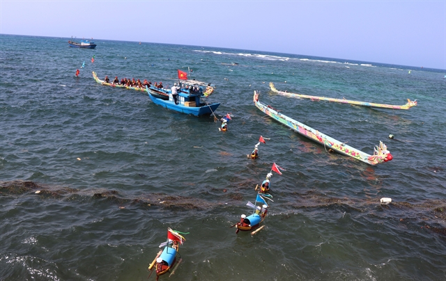 |
| ‘Lễ khao lề thế lính Hoàng Sa’ aims to commemorate soldiers of Hoàng Sa Flotilla who sacrificed their lives over the centuries guarding the Hoàng Sa and Trường Sa archipelagoes. — VNA/VNS Photo Phạm Cường |
HÀ NỘI — Hoàng Sa (Paracels) and Trường Sa (Spratlys), like inseparable pieces of Vietnamese blood and flesh, form part of the country’s territory, which is an immutable truth cherished by the Vietnamese people for generations. Fifty years have passed since January 19, 1974, when Hoàng Sa was illegally occupied by China, this archipelago remains a persistent concern of the Vietnamese people.
Việt Nam's sea area covers about one million sq.km, three times larger than the mainland area and making up nearly 30 per cent of the area of the East Sea (known internationally as the South China Sea). It is home to thousands of islands of all sizes that scatter rather evenly along the coastline and in the outpost archipelagoes of Hoàng Sa and Trường Sa.
Historical and legal evidence testifying to Việt Nam's sovereignty over these two archipelagoes have been recognised by many countries, the international community, and many scientists who have affirmed that the State of Việt Nam was the first in history to possess and exercise sovereignty over the islands.
Việt Nam's possession and exercise of sovereignty over Hoàng Sa and Trường Sa are clear, uninterrupted, peaceful, and in accordance with the existing principle of acquisition of territory – the principle of actual possession – of public international law.
Maps dating back to the 17th century feature Hoàng Sa and Trường Sa as a single strip which was initially called “Bãi Cát Vàng” (yellow sand beach) by Vietnamese people, as seen in “Toản tập Thiên Nam tứ chí lộ đồ thư” (Route Map from the Capital to the Four Directions) – a map compiled by geographer Đỗ Bá (Công Đạo) and completed in 1686.
In the first half of the 17th century, the Nguyễn Lords established the “Hoàng Sa flotilla”, which gathered people from An Vĩnh Commune of Bình Sơn District, Quảng Nghĩa (present-day Quảng Ngãi Province) to collect objects from stranded ships and catch rare seafood in Hoàng Sa. The lords also set up the “Bắc Hải flotilla”, whose members were residents of Tứ Chính hamlet or Cảnh Dương Commune of Bình Thuận, to perform similar duties in Trường Sa.
Throughout three centuries – from the 17th to the late 19th century, despite different dynasties, the monarchical state of Việt Nam established, practised management, and exercised the country’s sovereignty over Hoàng Sa and Trường Sa without encountering any dispute or objection.
This fact was proved in many old documents, books, and legal documents of the State, along with the maps showing Việt Nam's exercise of its sovereignty over the two archipelagoes, kept in Việt Nam and many countries, including “Toản tập Thiên Nam tứ chí lộ đồ thư” by Đỗ Bá, “Phủ biên tạp lục“ (Miscellany on the Government of the Marches, 1776) by noted 18th-century scholar/encyclopedist Lê Quý Đôn, “Lịch triều hiến chương loại chí” (Regulations of Successive Dynasties by Subject-Matter, 1821) by 19th-century historian Phan Huy Chú, “Hoàng Việt địa dư chí” (Geographical Treatise of Imperial Việt Nam, 1833), “Đại Nam thực lục tiền biên” (Veritable Records of the Great South, Prequel Records, 1844-1848), and “Đại Nam thực lục chính biên” (Veritable Records of the Great South, Principal Records, 1844-1848).
In particular, the World Atlas by Philippe Vandermaelen, published in Belgium in 1827, clearly drew and depicted Hoàng Sa as part of the territory of the Kingdom of An Nam, an old name of Việt Nam.
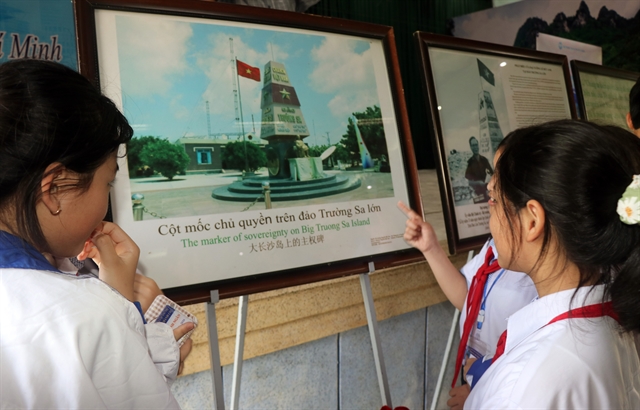 |
| Students visit an exhibition on Hoàng Sa and Trường Sa held in Quảng Tri Province. — VNA/VNS Photo |
Besides, the imperial archives of the Nguyễn Dynasty (1802-1945) are also important evidence proving the monarchical state of Việt Nam's establishment and implementation of many activities to exercise sovereignty over the two archipelagoes such as sending the Bắc Hải and Hoàng Sa flotillas there to exploit maritime resources, collect goods from sunken ships, measure and draw maps, erect steles, build shrines, plant trees, and support foreign vessels in distress. The precious records of the Nguyễn Dynasty were recognised as world documentary heritage by UNESCO.
In 1975, together with the complete liberation of the South and the national reunification, the Việt Nam People’s Navy also liberated the islands kept by the Saigon troops such as Trường Sa, Sơn Ca, Nam Yết, Song Tử Tây, Sinh Tồn, and An Bang, which are part of the Trường Sa archipelago. The then Provisional Revolutionary Government of the Republic of South Việt Nam also issued a statement affirming Việt Nam's sovereignty over Hoàng Sa and Trường Sa.
On July 2, 1976, at its first session, the 6th-tenure National Assembly (NA) (1976-1981) – the parliament of the reunified Việt Nam that was elected on April 25, 1976 – decided to rename the country the Socialist Republic of Việt Nam. The State of the Socialist Republic of Việt Nam has continued to manage and protect the country’s sovereignty over Hoàng Sa and Trường Sa via a number of activities that ensure the sufficiency of and adherence to procedures during the legal struggle while at the same time consolidating and maintaining the presence of Vietnamese soldiers and people on the geographical entities currently managed by the State of the Socialist Republic of Việt Nam.
Particular, in 1982, Việt Nam established the districts of Hoàng Sa and Trường Sa, with Hoàng Sa District now being part of the central city Đà Nẵng and Trường Sa District being part of the south-central Khánh Hoà Province.
Given these facts and records, Việt Nam possesses sufficient historical evidence with legal value to testify to and protect its sovereignty over these two archipelagoes throughout history.
It is noteworthy that the Resolution of the United Nations General Assembly, dated October 24, 1970, stated: “The territory of a State shall not be the object of military occupation resulting from the use of force in contravention of the provisions of the Charter. The territory of a State shall not be the object of acquisition by another State resulting from the threat or use of force. No territorial acquisition resulting from the threat or use of force shall be recognised as legal.”
Therefore, China’s use of force to occupy Hoàng Sa, an integral part of Việt Nam's territory, on January 19, 1974 ran counter to international law and this cannot generate a legal right towards this archipelago for China.
Hoàng Sa is forever a territorial part of Việt Nam! — VNA/VNS
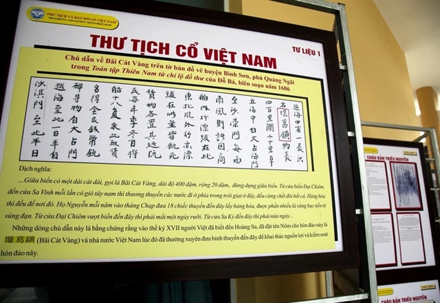 |
| Notes on Hoàng Sa (yellow sand beach) in the “Toản tập Thiên Nam tứ chí lộ đồ thư” by Đỗ Bá. — VNA/VNS File Photo |
Politics & Law
 Politics & Law
 Politics & Law
 Politics & Law
 Politics & Law
 Politics & Law
 Politics & Law
 Politics & Law
 Politics & Law
 Politics & Law
 Politics & Law
 Politics & Law
 Politics & Law
 Politics & Law
 Politics & Law