 Environment

BM Windows launches one of Southeast Asia's largest LEED Gold-certified factories
1.
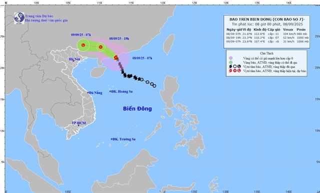 |
| The direction of Typhoon Tapah. Photo nchmf.gov.vn |
HÀ NỘI — Typhoon Tapah may have fizzled into a low-pressure system after making landfall in southern China on Monday, but its remnants are still expected to soak northern Việt Nam, with heavy rain and flash flood warnings in place from Tuesday afternoon.
According to the National Centre for Hydro-Meteorological Forecasting, the northern mountainous and midland regions could see rainfall of 40–90mm through Wednesday, with isolated areas receiving over 200mm. Some locations may see two-day totals exceeding 300mm.
"Total rainfall on Tuesday and Wednesday across the northern mountainous and midland areas is forecast at 70–150mm, with localised amounts of more than 300mm," said Deputy Head of the centre's Weather Forecasting Office Vũ Anh Tuấn.
Heavy showers are forecast to continue into Wednesday, with average rainfall of 30–60mm and some areas topping 100mm.
While Tapah weakens over China’s Guangxi Province, the storm’s outer circulation is still lashing the north-western East Sea with winds of 60–117km/h and waves up to 6 metres. Rough seas and dangerous conditions are expected to persist, with strong gusts, whirlwinds and thunderstorms posing risks for vessels, especially around the Gulf of Tonkin and northern coastal areas.
Although Việt Nam will not take a direct hit, authorities have warned that the storm’s outer bands could still trigger hazardous weather across the north, including whirlwinds and strong gusts.
The Central Highlands and southern provinces are also on alert. Showers and thunderstorms on Monday evening are expected to bring localised downpours of 15–30mm, with some areas exceeding 80mm. Thunderstorms may include lightning, hail, whirlwinds and strong gusts.
Warnings have been issued for sudden rainfall of more than 60mm in under three hours, increasing the risk of flooding in low-lying and urban areas, flash floods in small rivers and streams, and landslides in steep terrain. Real-time risk maps are available at https://luquetsatlo.nchmf.gov.vn.
In Đồng Nai Province, the Đồng Nai River’s water levels remained above level two flood warning thresholds between 10am and 9pm on Monday. Although levels are expected to fall slightly over the next 12–24 hours, the risk of flooding and riverbank erosion remains high.
“These forecasts are based on expected water discharges from upstream reservoirs. Updates will be issued if discharge volumes change,” said Deputy Head of the Hydrological Forecasting Office Nguyễn Tiến Kiên.
The storm, which struck Guangdong Province early Monday with peak winds of up to 117km/h, is forecast to continue weakening as it moves west-northwest across southern China at speeds of 20–25km/h. — VNS
Environment
 Environment
 Environment
 Environment
 Environment
 Environment
 Environment
.jpg) Environment
Environment
 Environment
 Environment
 Environment
 Environment
 Environment
 Environment
 Environment