 Society

The natural disaster destroyed or damaged 1,232 houses.

|
HÀ NỘI Storm Podul, the fourth hitting the East Sea this year, had left three people dead and four others injured in the central region as of Sunday.
According to the National Steering Committee for Natural Disaster Prevention and Control, the natural disaster destroyed or damaged 1,232 houses, submerged 405 others and harmed 6,769ha of rice and 403ha of vegetables. A total 6,370 domesticated animals were killed or swept away, while damage was inflicted on 2,941ha of aquatic farming.
To tackle these consequences, the office has asked localities to track rain, flood, and tropical depressions near the East Sea.Resources are needed to help residents repair their houses and fix damage, while dyke systems and natural-disaster-prevention facilities need to be examined, it added.
The committees for natural disaster prevention and control and for search and rescue activities of provinces and cities have been tasked with inspecting areas at high risk of flash flood and landslide to evacuate residents. Relevant forces should also be ready to tackle any problems in areas prone to flooding.
According to the National Centre for Hydrometeorology Forecasting, Storm Podul landed in the central region early last Friday.
Due to the impact of the storm, provinces from Nghệ An to Quảng Trị suffered strong winds, while localities from Nghệ An to Thừa Thiên-Huế saw heavy rains from 100-250mm.
Tropical pressures
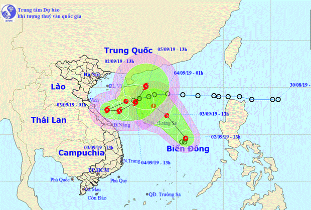
Two tropical pressures have recently formed in the East Sea and are forecast to cause strong winds and high waves for the whole East Sea area.
Central localities from Thanh Hoá to Quảng Ngãi are expected to face heavy rains of 300-500mm, while rains of 200-300mm are forecast for provinces in the Central Highlands.
Of the two tropical pressures, the nearer one was moving southwest at a speed of 15km per hour and is forecast to become stronger to develop into a storm tomorrow, according to the latest report from the National Hydro-meteorological Forecast Centre.
The storm is expected to be above the sea areas of central provinces from Hà Tĩnh to Quảng Nam at about 4am today with wind speeds of 60-75km per hour.
It will then move east and is expected to be 150km from the northeast of the mainland of Quảng Trị to Quảng Nam provinces at 4pm the same day.
The storm will keep moving northeast at a speed of 10km and will be located above the sea area of China's Hainan Islands at 4pm tomorrow.
The other low pressure system is moving northwest at a speed of 10-15km per hour and is forecast to be located 180km north of the Hoàng Sa (Paracel) Islands at 4am tomorrow.
It is expected to join the pressure above the Hainan Islands in the next 36 hours, the centre said.
The National Steering Committee for Natural Disaster Prevention and Control yesterday sent an urgent message telling localities to prepare for the possibility that the tropical pressures could become storms.
It asked the steering committees for natural disaster prevention and control of localities to keep close watch on the systems and monitor vessels at sea as well as maintain regular communications with their owners.
They were told to take the initiative to safeguard tourists on islands.
It also instructed authorities of localities to prepare to relocate residents in areas at high risks of landslides and flash floods, ready rescue equipment and forces, upgrade dyke systems and have measures to protect electricity lines and communications networks. VNS


