 Society


Việt Nam, Czech Republic step up local investment, trade cooperation
1.
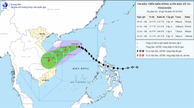 |
| Forecast path of the storm in the next few days. Photo thoitietvietnam.gov.vn |
ĐÀ NẴNG — Typhoon Fengshen, the twelfth tropical storm to enter Vietnamese waters this year, is moving westward toward the Hoàng Sa (Paracel) Archipelago, with forecasters warning of powerful winds and potentially devastating rainfall across central Việt Nam in the days ahead.
At 4am on Tuesday, the storm was located about 200km northeast of Hoàng Sa. Wind speeds near the centre reached levels 9-10 on the Beaufort scale (75–102 km/h), gusting to level 12 (118-133 km/h).
The system is travelling west at roughly 20 km/h, and though its strength has held steady, meteorologists say its path has continued to shift.
Fengshen is expected to reach the northwestern waters of Hoàng Sa early Wednesday, still packing winds of level 9-10 and gusts up to level 12, before tracking toward Việt Nam’s central coast.
By Thursday morning, it will likely be off the shoreline between Huế and Quảng Ngãi with winds reduced to level 6 (39-49 km/h), gusting to level 8 (62-74 km/h), and may weaken into a tropical depression before making landfall.
The storm is forecast to move inland over southern Laos by Friday, fading into a low-pressure area.
The northern part of the East Sea (internationally known as the South China Sea), including Hoàng Sa, is already seeing rough seas, with waves reaching 3-5m and up to 7m near the storm’s centre.
Authorities have warned that all vessels operating in the waters of central localities face severe risks from thunderstorms, whirlwinds, strong winds and high waves.
On Monday, Đà Nẵng city officials held an emergency online meeting with local wards to coordinate the city’s response to Fengshen.
The city’s Civil Defence Steering Committee described the storm as a fast-moving and powerful system capable of causing flash floods, landslides and widespread coastal inundation.
Forecasters warned that from October 23 to 26, the city could face hefty rainfall, with total accumulations of 100–200mm and localised downpours exceeding 300mm.
As of Monday morning, Đà Nẵng’s Border Guard Command reported 4,148 fishing vessels with more than 21,000 crew members registered in the city, including 264 still operating at sea.
All have been instructed to steer clear of hazardous areas, while rescue forces and equipment remain on standby.
Authorities are preparing evacuation plans for more than 210,000 residents living in flood-prone and landslide-risk zones. About 300 small and medium-sized boats from volunteer groups and the armed forces will be deployed to assist with evacuation and emergency relief operations.
These boats will be stationed across key wards and communes, ready to deliver essential supplies or help residents evacuate if roads become impassable. Officials are also considering distributing life jackets to households in low-lying areas.
Local governments have been instructed to activate the 'four-on-the-spot' emergency plan, ensuring command, manpower, materials and logistics are available locally, and to suspend classes when heavy rains occur. — VNS
Society
 Society
 Society
 Society
 Society
 Society
 Society
 Society
 Society
 Society
 Society
 Society
 Society
 Society
 Society