 Life & Style

HCM City unveils commendation records of war veterans
1.
|
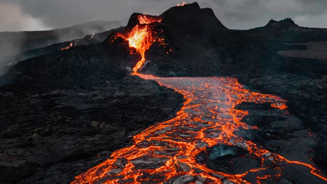
| After first erupting on Tuesday, Mt. Ruang again erupted on Saturday at around 1 a.m. local time, according to the Energy and Mineral Resources Ministry (ESDM), spewing an ash column to a height of around 1,200 meters. Photo Unplast |
JAKARTA – Amid heightened activity at several volcanoes across the country, authorities have urged the public to stay vigilant about potential eruptions and to refer only to information from credible sources.
The Center for Volcanology and Geological Hazard Mitigation (CVGHM) maintained on Saturday the level of Awas (warning) for Mount Ruang in North Sulawesi. Also known as a red alert, the center first imposed the highest level of the four-tier national alert system on the volcano after a series of eruptions on Wednesday.
Aside from Mt. Ruang, five other volcanoes still remain at the third-highest Siaga (watch; orange alert) level: Mt. Awu in North Sulawesi, Mt. Ile Lewotolok in East Nusa Tenggara (NTT), Mt. Marapi in West Sumatra, Mt. Merapi in Central Java and Mt. Semeru in East Java.
The CVGHM maintained the level of Waspada (advisory; yellow alert) for Mt. Gamalama in North Maluku, despite reports of increasing seismic activity at the stratovolcano.
“People living close to the mountains now in a critical state are to follow recommendations from officials,” CVGHM head Hendra Gunawan told The Jakarta Post on Saturday.
For volcanoes with an Awas (red alert) designation, no visitors are allowed within a distance of 6 kilometers from the crater, while a Siaga (orange alert) designation means people are not allowed within a 5 km radius from the crater.
More eruptions
After first erupting on Tuesday, Mt. Ruang again erupted on Saturday at around 1 a.m. local time, according to the Energy and Mineral Resources Ministry (ESDM), spewing an ash column to a height of around 1,200 meters.
Standing 725 m above sea level on Ruang Island in Siau Tagulandang Biaro (Sitaro) Islands regency, around 110 km from the provincial capital Manado, Mt. Ruang’s largest eruption this past week occurred on Wednesday, when it emitted a 3,000 m column of ash hot ash.
As of Saturday afternoon, volcanic ash and rock from Mt. Ruang had covered 10 villages and two subdistricts on neighboring Tagulandang Island, said a statement from the National Disaster Mitigation Agency (BNPB).
The BNPB previously ordered the evacuation of more than 11,000 residents at potential risk following the volcanic activity on Wednesday.
Thousands of local residents have taken shelter across the regency, mostly on Tagulandang Island, and at least 6,045 residents of the Bahoi and Balehumara subdistricts are headed to shelter in North Tagulandang on the neighboring island.
“We’re still updating the total number of evacuees,” BNPB spokesperson Abdul Muhari said in a statement on Saturday.
The disaster agency also recorded that the volcanic eruptions had damaged at least 135 houses, two churches and an elementary school.
Volcanic ash from Mt. Ruang has spread as far as Manado, forcing authorities to prolong the closure of Sam Ratulangi International Airport until at least 12 p.m. on Sunday.
The airport’s closure meant that officials have had to reroute humanitarian aid deliveries by land through neighboring Gorontalo province and from Bitung Port in North Sulawesi, and the BNPB has readied a helicopter to transport aid to affected residents.
Meanwhile, the Indonesian Navy and the National Search and Rescue Agency (Basarnas) have deployed several ships to help transport the aid and evacuate people.
From Java to Maluku
Officials also observed that Mt. Semeru in East Java was continuing to emit hot ash on Saturday to a maximum height of 1,500 meters.
On Thursday, high rainfall around the highest mountain on Java triggered landslides along its slopes and a cold lava flow as a local river burst its banks. The resulting flooding affected at least nine districts in Lumajang regency, East Java.
The BNPB reported on Saturday that at least two people were killed when they were swept away by the floodwaters and another person was killed in the landslides, while the cold lava flow damaged several homes and destroyed at least eight bridges.
“The incident cut off the national [highway] connecting Lumajang and Malang,” said the BNPB’s Abdul, adding that officials were still repairing the road as of Saturday.
The increasing seismic activity around Mt. Gamalama, which has been erupting since 1538 and which the CVGHM has placed on yellow alert since 2015, has raised concerns of an impending eruption among local residents.
But the CVGHM has dismissed the rumor, saying that the volcano might experience a phreatic eruption, emitting a blast of steam that may only affect areas around the crater, regional media outlets reported.
A phreatic eruption occurs when hot volcanic materials such as magma and lava heat ground or surface water, according to the United States Geological Survey (USGS), boiling or flashing the water to generate an explosion of steam, water, ash and other materials.
Although several volcanoes across the country were experiencing heightened activity, the CVGHM’s Hendra said the eruptions were unrelated to each other.
“Each mountain has a different system,” he said on Saturday. “The erupting volcanoes are [located] relatively far from each other.” - The Jakarta Post
Life & Style
 Life & Style
 Life & Style
 Life & Style
 Life & Style
 Life & Style
 Life & Style
 Life & Style
 Life & Style
 Life & Style
 Life & Style
 Life & Style
 Life & Style
 Life & Style
 Life & Style